GRAVÜR DÜNYASI
Digital Engraving Library
| Artist | Thunot Duvotenay (1796-1875) |
| Date | 1840 |
| Technique | Steel Engraving |
| Category | Maps |
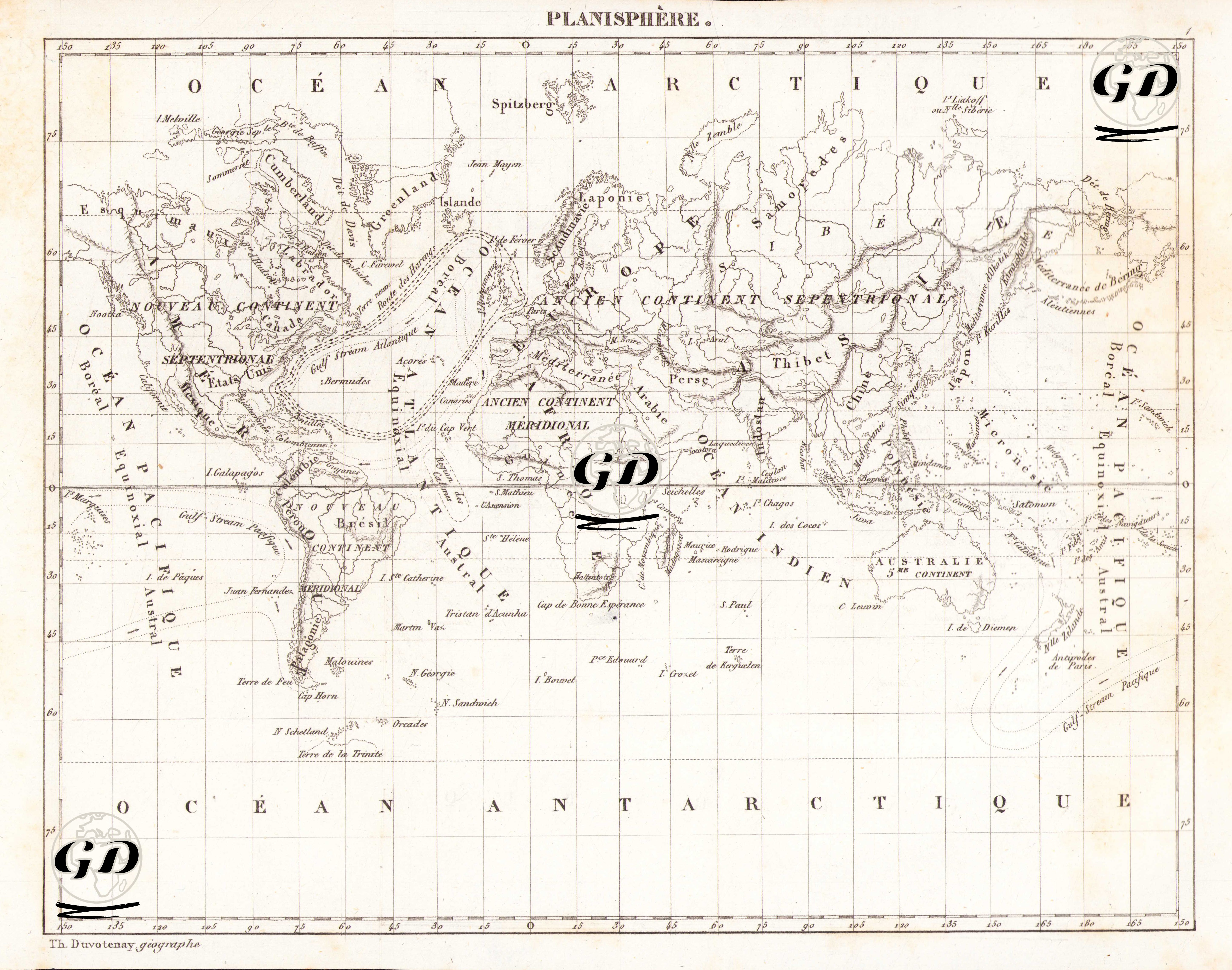
This world map dated 1840 was prepared by French geographer Thunot Duvotenay and titled "Planisphere" (world projection). Reflecting both the worldview and scientific geographical classifications of the time, this planisphere map was prepared using the Paris Meridian as a reference, and the continents and oceans were named in French. The map's language was French, the scientific language of the time, and therefore should be considered a product of the new knowledge systems that emerged following geographical discoveries, particularly in Europe. The projection type is cylindrical (centered on the equator), and the world is depicted on a plane extending north-south toward the poles and expanding east-west. Coordinates are displayed in the upper margin as "Longitude du Méridien de Paris" (longitude from the Paris Meridian). Europe, Asia and Africa were defined as the “Ancien Continent”, the Americas as the “Nouveau Continent”, and Australia as the “Australie ou 5e Continent” (Australia or the 5th Continent). Countries such as "États-Unis" and "Canada" in the Americas and "Brésil," "Pérou," and "Colombie" in South America are clearly shown. The oceans are named according to classical French terminology, such as "Océan Arctique," "Océan Indien," "Océan Pacifique," "Océan Atlantique," and "Océan Antarctique." Furthermore, considerable attention was paid to the depiction of islands and archipelagos on the map, such as Spitzberg (Svalbard Archipelago), the Galapagos Islands, and the Sandwich Islands. The Gulf Stream, designated as the "Atlantic Gulf Stream" on the map, is a warm ocean current originating in the Gulf of Mexico and flowing into the North Atlantic. It is particularly known for moderating the climate of northwestern Europe. For contemporary cartographers, this current was important not only for maritime trade and shipping but also for explaining Europe's climatic advantages. It is often shown as an arrowhead on 19th-century maps and is marked as one of the primary natural forces shaping sea routes. The "Gulf Stream Pacific," shown on the right side of the map, is a warm current in the Pacific Ocean and corresponds to the "Kuroshio Current" (or Japan Current) in modern terms. This warm ocean current, originating east of Japan and moving northeast across the Pacific Ocean, influences the climate along the eastern coast, much like the Gulf Stream in the Atlantic. The "Route des Harengs" on the map is the herring route. This refers to the migration routes of the herring schools, which are particularly dense in the North Sea and the northeast Atlantic, around Norway and Iceland. The "Route des Harengs" has been an important economic route since the 17th and 18th centuries, holding strategic importance for fishing nations (especially the Netherlands, England, and Denmark). The term "Région des Calmes" means "zone of calm" or "windless zone." This term describes the windless zone around the equator, known to sailors as "doldrums." Especially in the era of sailing ships, this region was known for its deadly stagnation, where progress stopped for months at a time.