GRAVÜR DÜNYASI
Digital Engraving Library
| Artist | Augustus Heinrich Petermann (1822-1878) |
| Engraver | John James Dower (1825-1901) |
| Date | 1850 |
| Technique | Copper Engraving-Original Hand Colored |
| Category | Maps |
| Source | A Descriptive Atlas of Astronomy, and of Physical and Political Geography by Thomas Milner - London, Published By Orr And Comp. Amen Corner Paternoster Row |
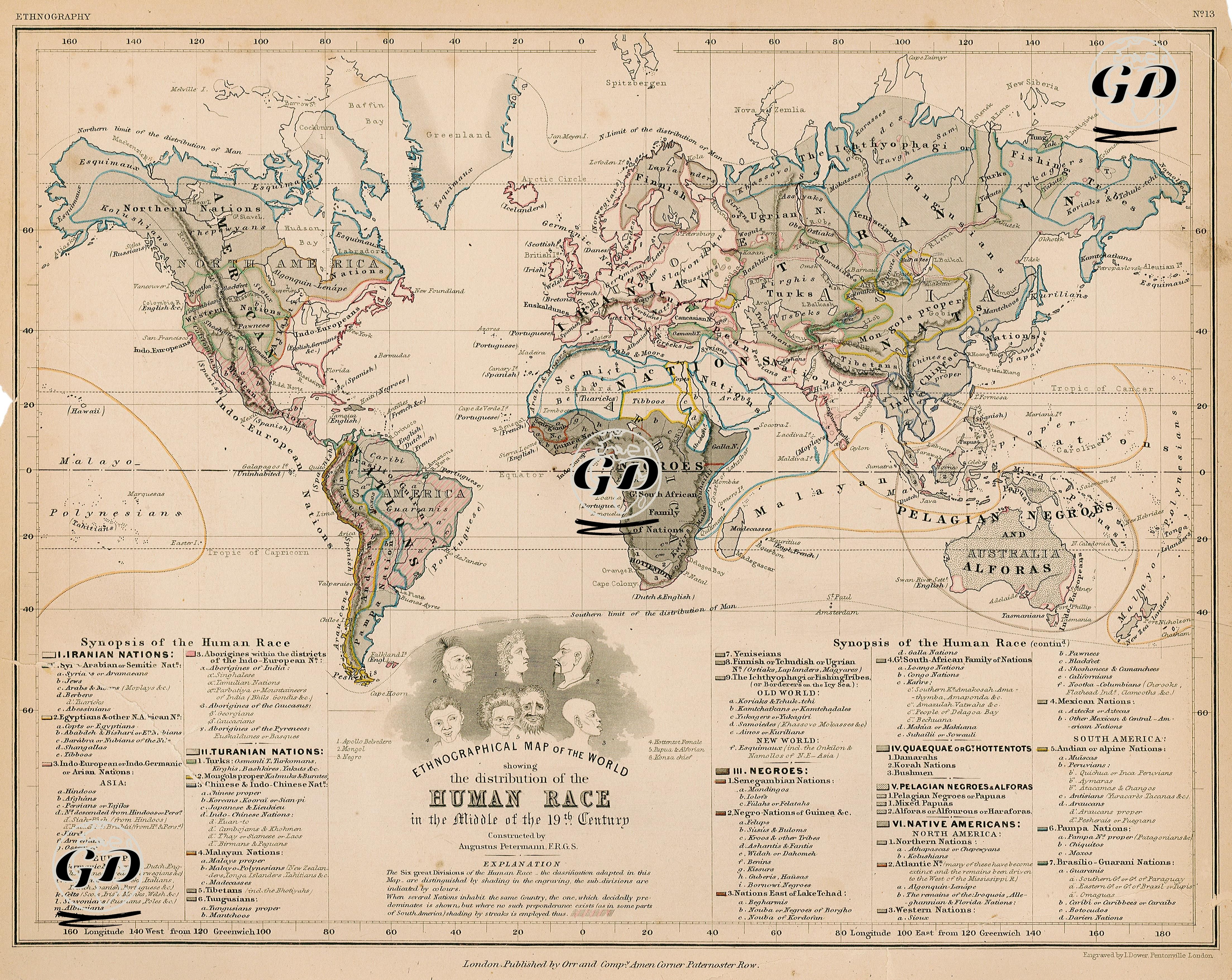
The map, titled “Ethnographic Map of the World” and dated 1850, is an ethnographic study that aims to describe the distribution of human races on earth. Prepared by Augustus Petermann, a German cartographer and member of the “Royal Geographical Society”, this work was developed by the rapidly developing disciplines of geography, anthropology and philology in Europe in the 19th century, which produced various models for classifying human societies. This map is an example of early ethnographic cartography, which was at the intersection of these disciplines and aimed to separate human species according to their physical characteristics, language groups and cultural practices. The map grouped humanity under six main “races” and divided each group into detailed subcategories. Although this classification is considered scientifically invalid today, it is important in terms of reflecting the European-centered anthropological understanding of the period. The Main Classes are as follows. Iranian Nations; It includes peoples belonging to the Indo-European language family and some Semitic and North African peoples. Ethnic communities such as Armenians, Arabs, Jews and Tuaregs were evaluated in this group. Turanian Nations include the Ural-Altai, Sino-Tibetan and Malayo-Polynesian peoples. Turks, Mongols, Finno-Ugric peoples, Malays, Japanese, Chinese and Eskimos are in this group. The map represents the Turkish peoples in both the Ottoman Empire and Central Asia. Tribes such as Negroes, Sub-Saharan African peoples, Mandingos, Fûlas, Ashantis, Kafirs are included in this class. In addition, the Swahili peoples of the East African coast are also specified. Hottentots and Bushmen (Kuekue); represent the Khoisan peoples in Southern Africa. These groups were evaluated as "primitive" and "separate" in Western anthropology of the period. Pelagic Negroes and Alfora; include the natives of Melanesia, Papua New Guinea and Australia. Peoples called "ocean blacks" such as the Papuans and Alforous peoples are included in this class. Native Americans; The indigenous peoples of North, Central and South America are discussed in a wide range such as Algonquins, Aztecs, Inca Quechuas, Patagonians, Guaranis. The map expresses racial distribution with hatching patterns and color codes. The dominant group sharing the same geography is represented; if there is equality, linear shading is used. The portrait key at the bottom represents the understanding of the "racial typology" of the period. These figures are typical anthropological characters such as Apollo Belvedere (European), Mongol, Negro, Hottentot Woman, Papuan, Indian Chief. This iconography, with the European figure in the central position, also visualizes the hierarchical understanding of race of the period. This map should be evaluated critically, with the acceptance that the concept of race in today's science is a social construction rather than a biological basis. Petermann's ethnographic map is important not only in terms of showing the geographical distribution of human communities, but also how the scientific knowledge production of the 19th century and the colonial mentality were intertwined. Today, such maps offer the opportunity for multi-layered analysis at the intersection of historical anthropology, cartography and cultural criticism.