GRAVÜR DÜNYASI
Digital Engraving Library
| Artist | Ernst Georg Ravenstein (1834-1913) |
| Engraver | Ernst George Ravenstein (1834-1913) |
| Date | 1878 |
| Technique | Woodblock Engraving (Newspaper-Text on Reverse) |
| Category | Maps |
| Source | The İllustrated London News (February 16 1878-Page 149) |
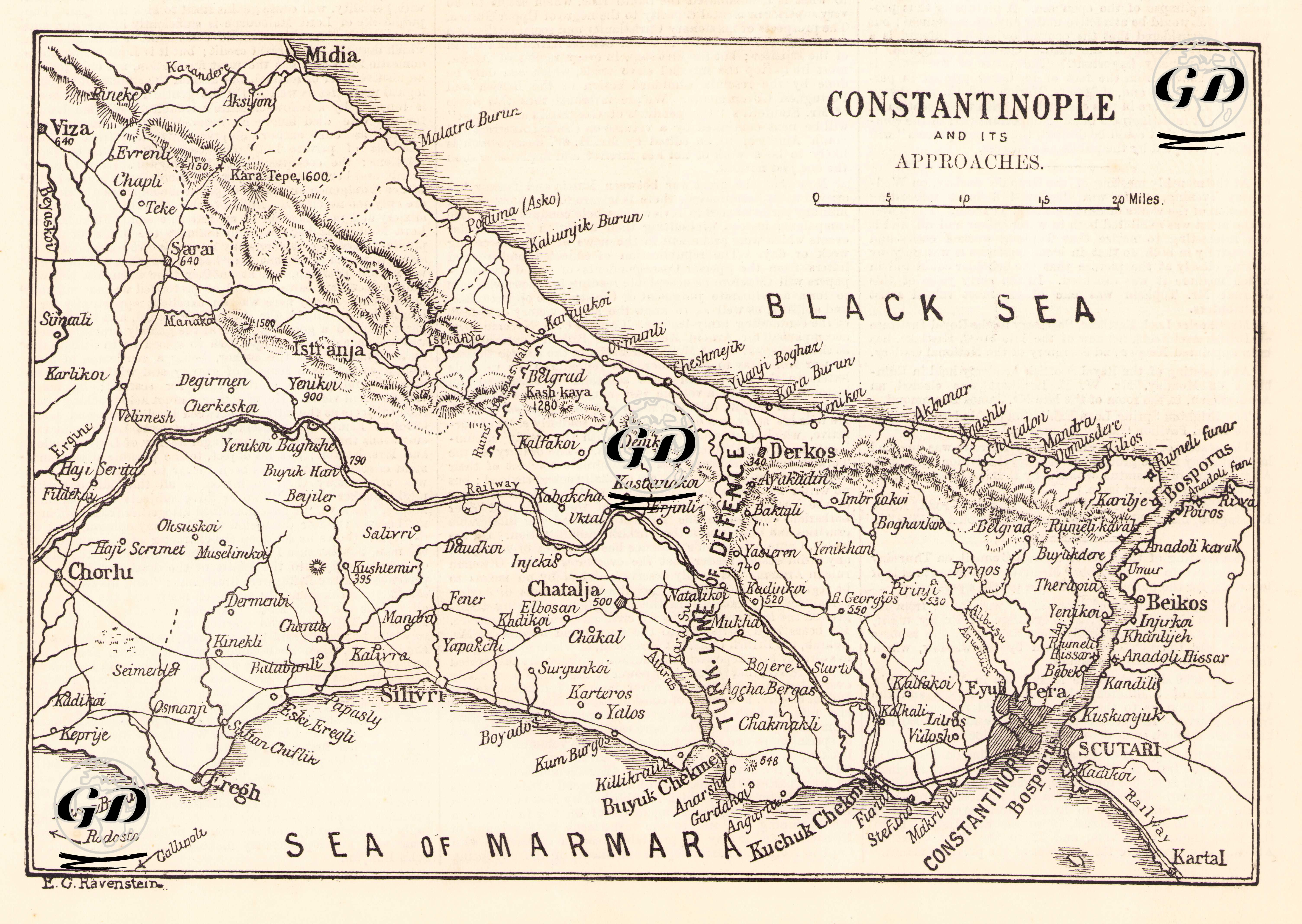
The map titled “Constantinople and Its Approaches” and the accompanying article from the Illustrated London News, dated February 16, 1878, provide a detailed analysis of the strategic position of the Ottoman capital, Istanbul, between the Black Sea and the Sea of Marmara—especially in the context of the imminent Russian threat. The map was created to illustrate how the city could be defended against a potential attack. The article emphasizes the military importance of specific areas such as the Çatalca Line, Lake Derkos, Büyükçekmece, Küçükçekmece, Silivri, Kartal, and Scutari (Üsküdar). It discusses not only the topographical advantages but also vital resources such as water supplies, railway lines, mountain ranges, and existing military deployments. The article considers the possibility of a Russian advance toward Istanbul through the Balkans and evaluates the city's natural and constructed defenses. In particular, the lakes of Küçükçekmece and Büyükçekmece are described as natural moats, forming the first defensive line against a land-based assault approaching from the west. The map’s annotation “Turk line of defence” denotes this system of natural and artificial fortifications extending from Silivri through Büyükçekmece, Küçükçekmece, Derkos, Göktürk, and the Istranja Mountains. The phrase “This is nature’s rampart for Constantinople” highlights how this region forms a natural barrier—considered the most significant obstacle preventing the fall of the city from the western front. Çatalca, with its mountainous terrain, is noted as particularly suitable for defense. The Belgrad Forest and the surrounding highlands are said to provide natural artillery positions within firing range, further contributing to the city’s protection. The article also evaluates the Bosphorus, including the Rumeli and Anadolu Fortresses, as key to organizing a multi-front defense—both from sea and land. Lake Derkos and its surrounding area are underlined as vital for the city’s drinking water supply, making its control crucial in any sustained conflict scenario. According to the Illustrated London News, the defense of Constantinople does not rely solely on military fortifications, but also on its geographical position, natural obstacles, and control over sea routes. The city's location (spanning both Europe and Asia) renders it not only essential to the Ottoman Empire but also strategically vital to all major global powers. This is best summarized by the article’s own words: “Constantinople stands on two quarters of the globe, and between two seas, and seems destined by nature to be the capital of the ancient continent.” In conclusion, the map and the accompanying article together serve as a significant source for understanding the strategic and military situation of Istanbul during the 1877–1878 Russo-Turkish War.