GRAVÜR DÜNYASI
Digital Engraving Library
| Artist | James Playfair (1738-1819) |
| Engraver | Samuel John Neele (1758-1824) |
| Date | 1814 |
| Technique | Copper engraving |
| Category | Maps |
| Source | A New General Atlas, Ancient and Modern by James Playfair-London, Published May 12 1814 by T.Underwood Fleet Street |
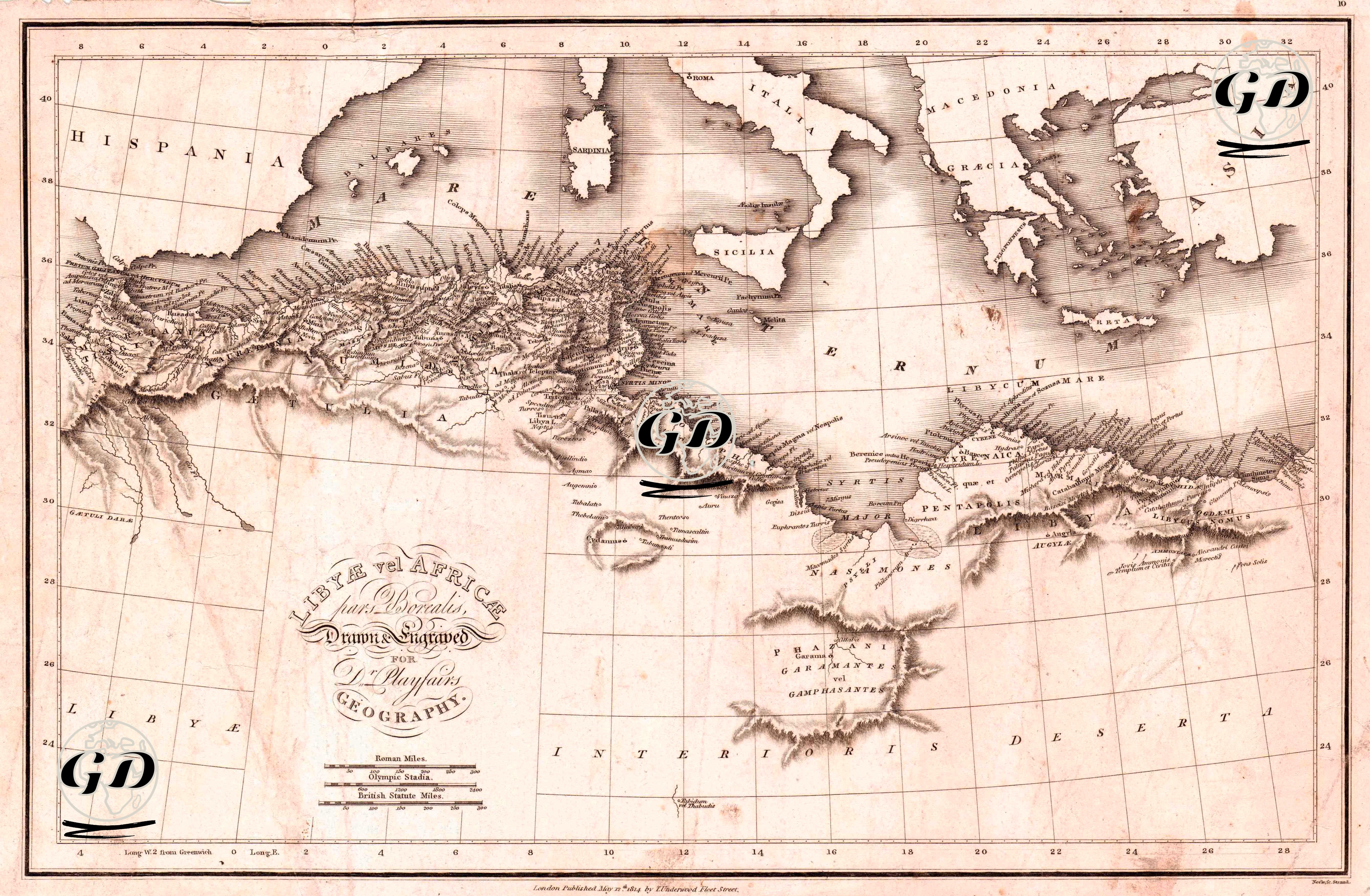
This map, titled “Libya and the Northern Region of Africa,” was prepared for Dr. James Playfair’s “Geography” atlas and printed in the early 19th century by Samuel John Neele using copperplate engraving. The map covers the North African coastal strip (present-day Morocco, Algeria, Tunisia, Libya, and the western part of Egypt) and the southern Mediterranean basin. To the north lie Spain, Italy, Greece, and the Aegean Islands. The measurement system is given using Roman and British mile values. The map is structured using a grid coordinate system, and the relief of mountainous areas is rendered using hachure (hatching-shading) technique. This map was produced during a period of increased European interest in North Africa after the Napoleonic era. The 1810s were a period of both a revival of ancient geographical studies and an acceleration of colonial exploration. The use of both "Libya" and "Africa Pars Borealis" in the map's title demonstrates a continuation of the naming tradition of ancient Roman geography. The North African coastline, particularly the Atlas Mountains, is depicted in detail, along with ancient settlements such as Cyrenaica (eastern Libya), Pentapolis, and Carthage. Large islands bordering the Mediterranean (Sicilia, Sardinia, Crete) and coastal cities (e.g., Leptis Magna, Alexandria, Utica) highlight the lines of maritime trade and cultural interaction of the time. The map only partially defines the area beyond the desert belt; the phrase "Libyæ Interioris Desertæ" (Inner Libyan Desert) visually marks the boundary of European knowledge. The map also represents a significant geography in the history of Christianity. Cities like Carthage, Alexandria, and Cyrene stood out as theological centers and episcopal regions in the early Christian period. Therefore, the fact that the map is structured around the axis of "ancient geography" is significant not only in terms of historical mapping but also in terms of mapping religious memory. At the same time, these regions reflect the early period of the cultural transformation shaped by the Islamic world from the 7th century onwards.