GRAVÜR DÜNYASI
Digital Engraving Library
| Artist | Ernst Georg Ravenstein (1834-1913) |
| Date | 1877 |
| Technique | Woodblock Engraving (Newspaper-Text on Reverse) |
| Category | Maps |
| Source | The Illustrated London News (May 26 1877- Page 501) |
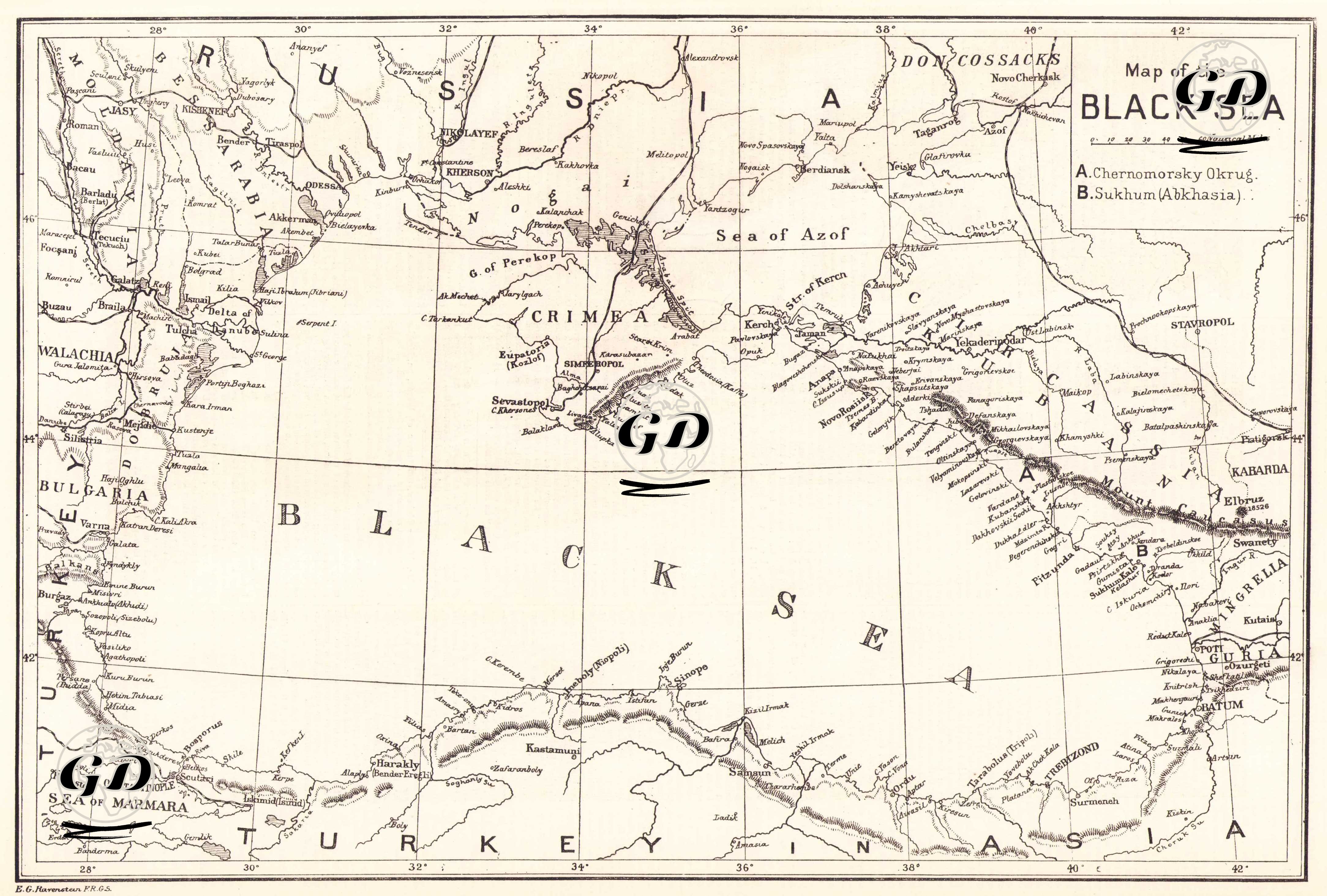
This map, published in The Illustrated London News on May 26, 1877, brings together within a single cartographic framework the broadest strategic area defining the European and Caucasian fronts of the 1877-78 Russo-Turkish War. The map presents the entire geography surrounding the Black Sea (Crimea, the Sea of Azov, the Danube Delta, the Bulgarian coast, the Marmara Passage leading to the Bosphorus, the northern line of Anatolia, and the Caucasian coast) as an analytical tool for assessing the military and political dimensions of the war. The Black Sea was the central theater of the power struggle between the Ottoman Empire and Tsarist Russia in the 19th century, and the logistics lines provided to the Caucasus and the Balkans by the Russian navy from ports such as Odessa, Cherson, Nicolaeif, and Sevastopol played a decisive role in the expanding front of the war. While the Crimean Peninsula, the Kerch Strait, and the Sea of Azov region stand out as critical points supporting Russia’s full dominance of the Black Sea, the Caucasus coasts marked as “A” (Chernomorsky Okrug) and “B” (Sukhum/Abkhazia) on the map bear the traces of the Russian Empire’s century-long Caucasian expansion. This coastal line was one of the most important areas where Ottoman and Circassian forces resisted during the 1877 War. Because the mountain ranges run parallel to the sea, it presented an extremely challenging geography for both attack and defense. The Ottoman Empire's Black Sea coast (Istanbul, Sinop, Samsun, Trabzon, and Batumi) was vital throughout the war, ensuring the security of the capital, transporting troops and ammunition to the Caucasus front, and maintaining coastal defenses. The prominent display of the Danube Delta on the map emphasizes the strategic nature of the Russian river crossings that initiated the operations on the Balkan front. The Russian army advanced into the interior of Bulgaria from Dobruja and the Danube crossings. This map demonstrates that the '93 War was not fought on a single front but simultaneously across a vast geography surrounding the Black Sea. The areas extending from Crimea to Sukhumi, and from the Danube Delta to Istanbul, were all critical nodes in war planning.