GRAVÜR DÜNYASI
Digital Engraving Library
| Artist | Sidney Hall (1788-1831) |
| Engraver | Sidney Hall (1788-1831) |
| Date | 1821 |
| Technique | Copper Engraving-Original Hand Colored |
| Category | Maps |
| Source | A New General Atlas - London, Published by Longman, Hurst, Rees, Orme & Brown, Paternoster Row, Dec. 27th, 1821 |
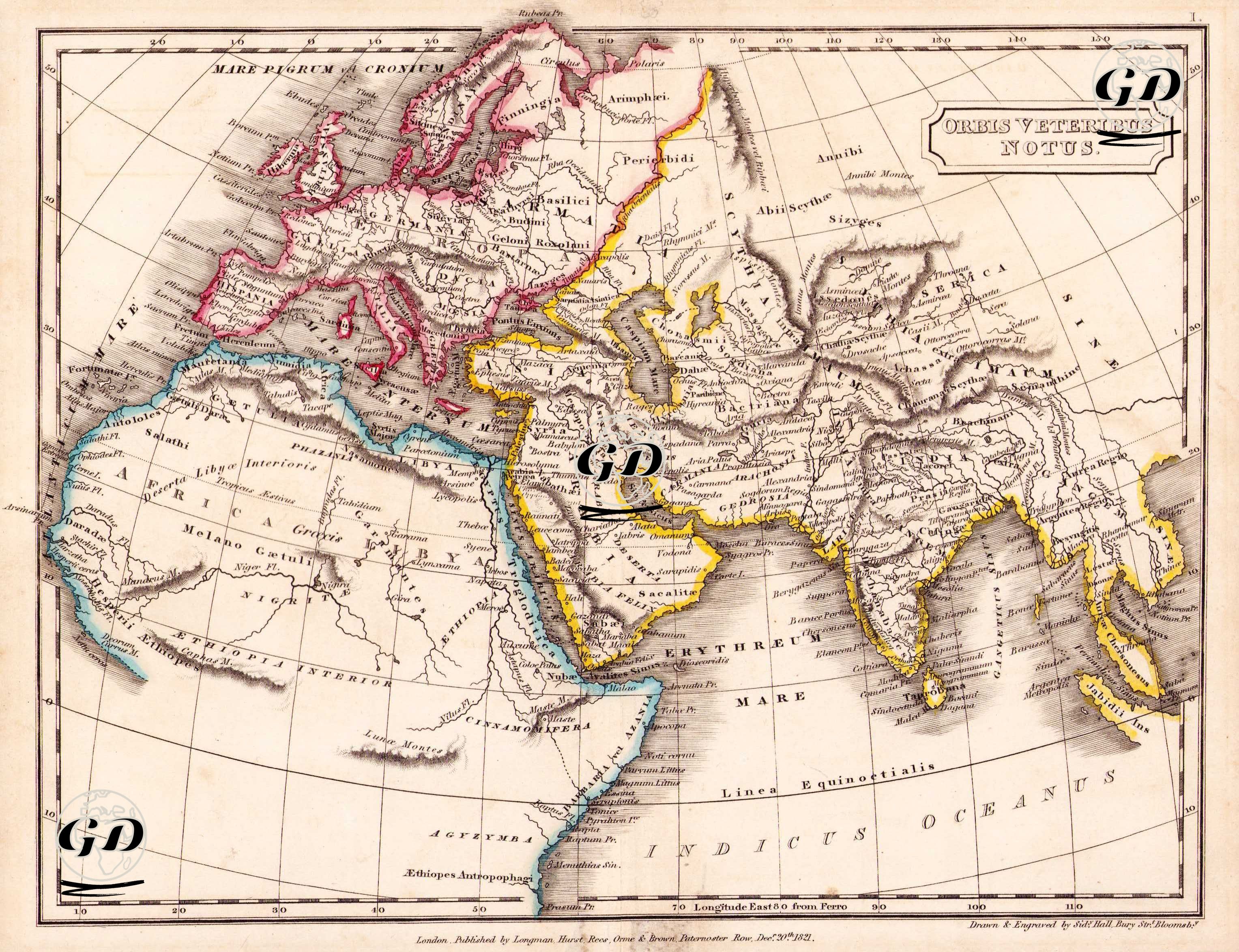
This map is one of the classical period maps depicting the ancient world, titled "ORBIS VETERIBUS NOTUS," published by Longman, Hurst, Rees, Orme & Brown in London on December 25, 1821. The Latin phrase in the map title is "Orbis Veteribus Notus," meaning "The World Known by the Ancients." This term refers to the geographical areas known and understood in the thought of classical antiquity (especially the Greco-Roman period). Therefore, the map reflects the geographical understanding of the world held by the Greeks, Romans, and early medieval scholars, particularly from the 5th century BC to the 2nd century AD. Indeed, the map shows only the known part of the Old World (Africa, Europe, and southern Asia), excluding the Americas, eastern Far East Asia, sub-Saharan Africa, and Australia. This clearly demonstrates where the boundaries of geographical knowledge ended in antiquity. The map was inspired by the Roman geographer Pomponius Mela, the Greek historian Herodotus, the geographer Strabon, and especially Ptolemy's work "Geographia". Classical names are used on the map: for example, "Scythia" (the steppes of Central Asia), "India intra Gangem" (India west of the Ganges River), "Arabia Felix" (Fertile Arabia), and "Aethiopia" (the southern regions of Africa). Similarly, in Europe, instead of modern countries, Roman-era regional names such as "Gallia," "Hispania," "Germania," "Italia," and "Britannia" are used. Europe is outlined in red, North Africa and coastal Atlantic Africa in blue, and Asia and East Africa in yellow, providing a visual delineation of major civilizational basins. Seas such as "Mare Internum" (Mediterranean), "Mare Rubrum" (Red Sea), and "Mare Erythraeum" (the ancient name for the Indian Ocean) are also given Latin names. The equator is designated as the "Linea Aequinoctialis," leaving information about Africa further south at the bottom of the map unclear. Similarly, place names such as "Melano Gaetuli," "Nigritae," and "Aethiopes Autophragoi" are based on ethnographic information from ancient texts.