GRAVÜR DÜNYASI
Digital Engraving Library
| Artist | Heinrich Theodor Menke (1819-1892) |
| Date | 1866 |
| Technique | Copper Engraving-Original Hand Colored |
| Category | Maps |
| Source | Orbis antiqui descriptio [cartographic material] : an atlas illustrating ancient history and geography by eighteen maps by Heinrich Theodor Menke - Published by Justus Perthes, Gotha |
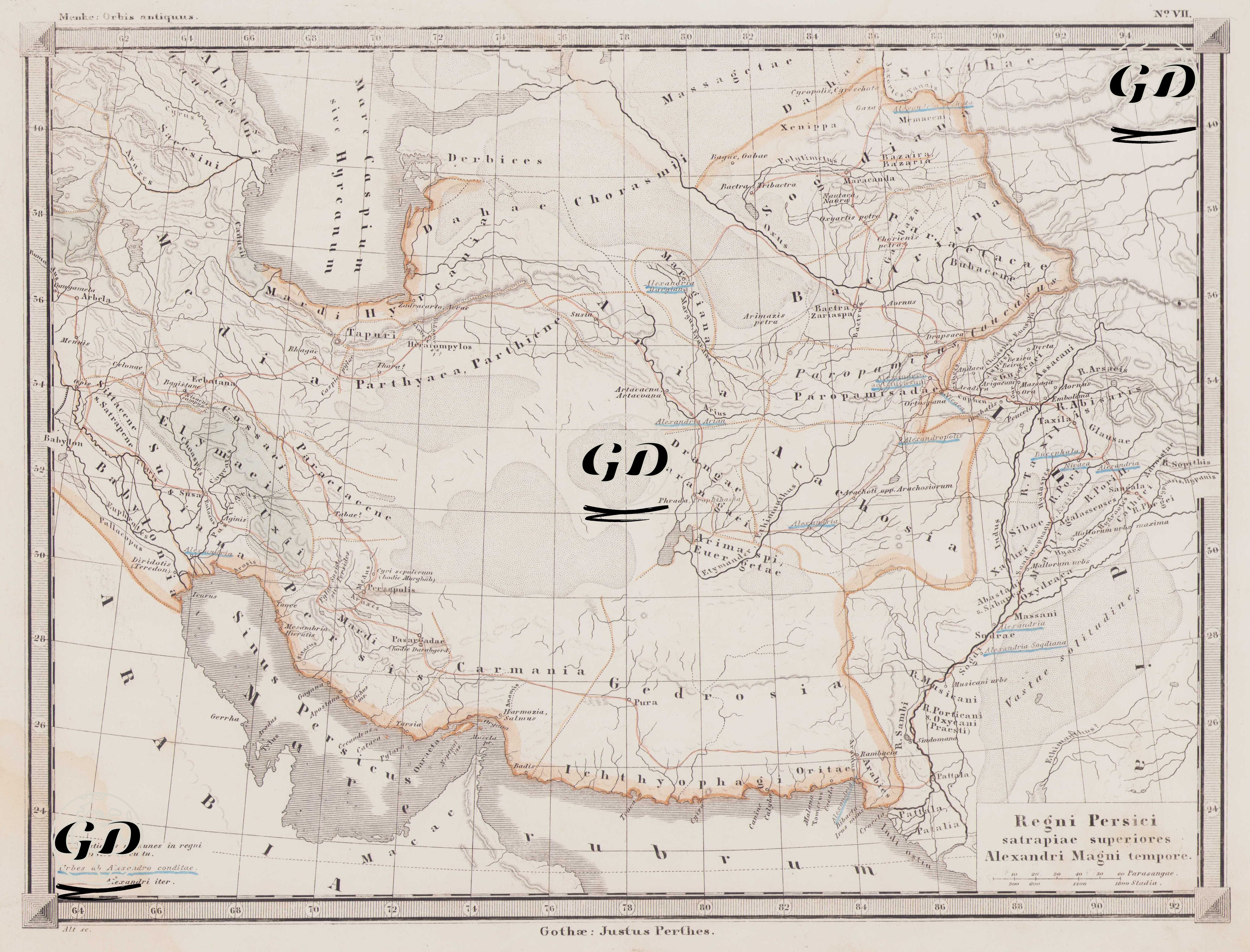
This map, titled "Regni Persici satrapiae superiores Alexandri Magni tempore" (The Upper Satrapies of the Persian Kingdom during the Reign of Alexander the Great), depicts the Persian Empire's territories extending into eastern and central Asia, particularly its administrative division at the satrapy (province) level. A "upper satrapy" refers to a larger administrative region where several satrapies were grouped together. The map is part of the ancient atlas series (Orbis Antiquus (Ancient World)) prepared by the 19th-century German publisher Justus Perthes and depicts the eastern borders, provinces, and ancient roads of the Persian Empire in detail, drawing on ancient geography. The area covered by the map corresponds to modern-day Iran, Turkmenistan, Afghanistan, western Pakistan, Tajikistan, Uzbekistan, and Azerbaijan. It begins with Babylon in the west and extends to the Indus River (Sindhu) valley in the east. In the north, ancient regions such as Hyrcania (around Gurgan), Sogdiana and Bactria, and in the south, regions such as Carmania (Kirman), Gedrosia (Makran) and Drangiana attract attention. Ancient satrapy names such as Parthia, Aria, Margiana, Arachosia, Sattagydia, Gandhara, Media, Persis (Fars), and Susiana (the region where Sus is located) represent regions of administrative and military importance during Alexander's Eastern Campaign. The legend in the lower left corner of the map reads: 1. Nationes immunes in regni Persici circuitu; designated as exempt peoples located outside the borders of the Persian Kingdom. 2. Urbes ab Alexandro conditae; cities founded by Alexander. These cities are marked on the map with special symbols (e.g., Alexandria Arachosiae, Alexandria in Aria, Alexandria Margiana). 3. Alexandri iter; Alexander's campaign route is shown with a thin red line, starting from Babylon and extending eastward to the Indian border. During Alexander the Great's Persian Campaign, between 334 and 323 BC, many new cities were founded as a result of the campaigns conducted in the eastern regions of the Persian Empire, and these regions came under Hellenistic rule and cultural influence. The map is particularly important for depicting Alexander's campaign route, which crossed the Hindu Kush Mountains and advanced into Bactria and Sogdiana. It also helps understand the geographical challenges Alexander's army faced, such as the Gedrosia desert crossing and the return route. This map is based on classical sources—especially the accounts of ancient historians and geographers such as Arrianos, Strabo, and Curtius Rufus. The satrapy names and cities incorporate both Achaemenid and Hellenistic geographical terminology.