GRAVÜR DÜNYASI
Digital Engraving Library
| Artist | Heinrich Theodor Menke (1819-1892) |
| Engraver | Carl Stier |
| Date | 1866 |
| Technique | Copper Engraving-Original Hand Colored |
| Category | Maps |
| Source | Orbis antiqui descriptio [cartographic material] : an atlas illustrating ancient history and geography by eighteen maps by Heinrich Theodor Menke - Published by Justus Perthes, Gotha |
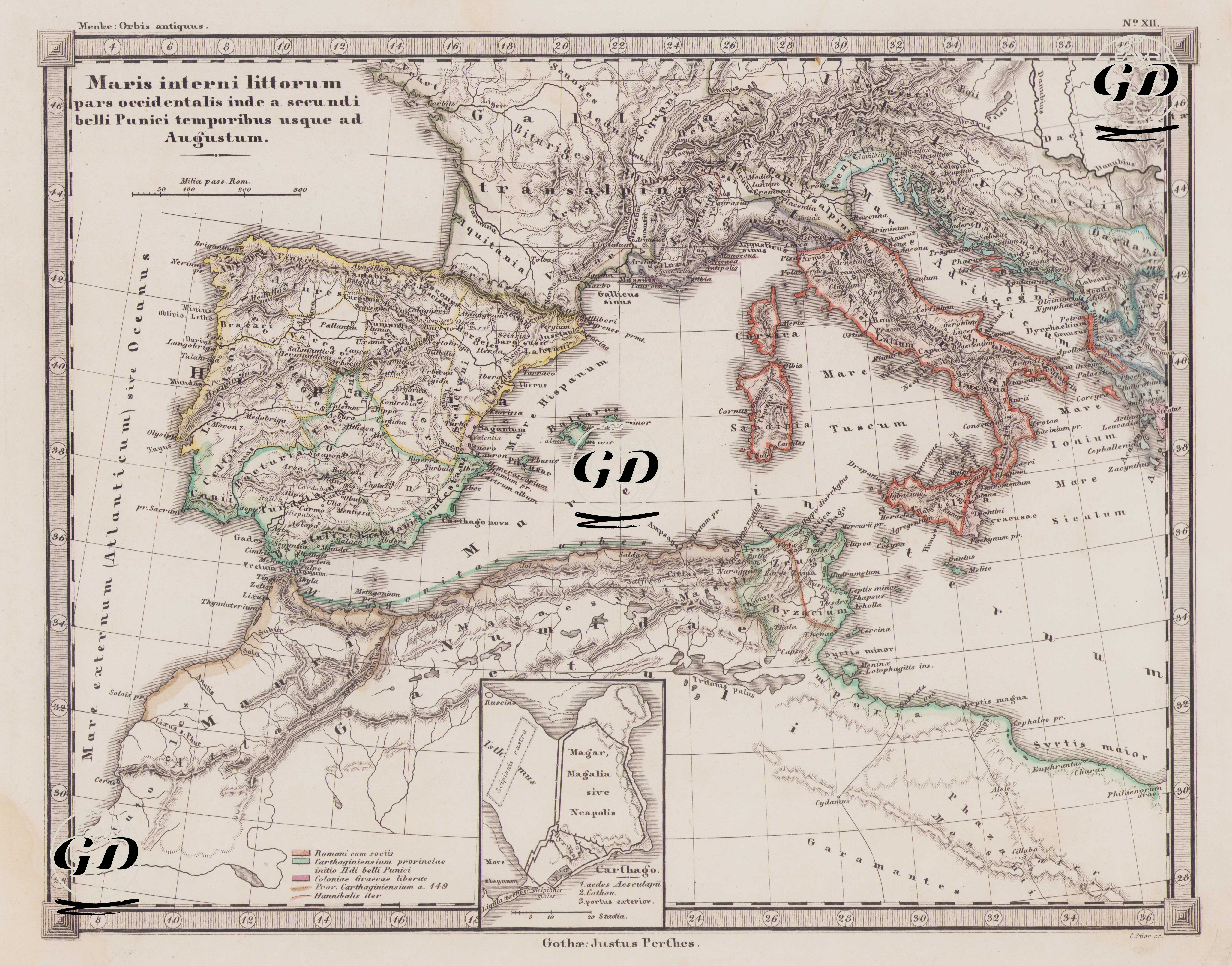
This map is map number XII of the Orbis Antiquus (Ancient World) atlas series in Justus Perthes's classical ancient geography series and is titled "Maris interni littorum pars occidentalis inde a secundi belli Punici temporibus usque ad Augustum." Translated into Turkish, it means "the western shores of the Inland Sea (Mediterranean) from the time of the Second Punic War to the reign of Augustus." The map depicts the political and military situation of the western Mediterranean between 218 BC and 14 BC, that is, from the Second Punic War to the reign of the Roman Emperor Augustus. This period marked the period when Rome established definitive dominance over the western Mediterranean with its victory over Carthage. The map covers a vast geography, starting from the Atlantic coast in the west and extending to Hispania (present-day Spain and Portugal), Gallia (the Gallic lands, the southern parts of present-day France), the Alps in the north, Italy and Sicily in the east, North Africa (the lands of Numidia and Carthage) in the south, and Libya and Cyrene in the east. The ancient borders, marked with colored lines in the legend, have their meanings in Latin. 1. Romani cum sociis (Romans and their allies): These regions, shown in red on the map, encompass the lands directly controlled by the Roman Republic, as well as other Latin colonies and client states in political and military alliance with it. This highlights the vast sphere of influence that Rome controlled, though not directly occupied. 2. Carthaginiensium provinciae initio IIᵈⁱ belli Punici (Carthaginian provinces at the beginning of the Second Punic War): These regions, shown in green, represent Carthage's overseas colonies and sphere of influence around the Mediterranean. Specifically, eastern Hispania, western Sicily, the North African coast, and the area around Sardinia and Corsica were under Carthage's control. 3. Coloniae Graecae liberae (Independent Greek colonies): These cities were former self-governing Greek colonies, generally established in western Anatolia, southern Italy, and Sicily. They often played important roles in the struggle for influence between Rome and Carthage. 4. Prov. Carthaginiensium a. 149 (Province of Carthage, 149 BC): This area represents Carthage's status and the last remaining central government before the Third Punic War in 149 BC. That same year, Carthage was besieged by Rome and completely destroyed. 5. Hannibalis iter (Hannibal's campaign route): This route, clearly outlined on the map, depicts the Carthaginian commander Hannibal Barca's famous march from Spain across the Alps into central Italy. This campaign is considered one of the greatest military threats in Roman history. This map shows in detail Rome's strategic expansion in the Western Mediterranean and Carthage's subsequent decline. It also reveals the geographical basis of the Rome-Carthage struggle, including Hannibal's attack on Roman territory across the Alps, Rome's alliance system, Carthage's colonies, and the location of the Greek city-states. The bottom of the map also features a detailed plan of the city of Carthage, which is of historical significance for examining the urban fabric of this ancient city, which was destroyed by Rome's devastating attack in 146 BC. Cartographically, this map is extremely detailed for its time. Its depiction of Roman roads, mountain ranges, river systems, and ancient cities with their original Latin names makes it a valuable visual resource for classical historiography and military geography. The map also provides a detailed spatial representation of Rome's expansion strategies during this period and the political and military measures that led to Carthage's demise.