GRAVÜR DÜNYASI
Digital Engraving Library
| Artist | Edward Weller (1819-1884) |
| Engraver | Edward Weller (1819-1884) |
| Date | 1874 |
| Technique | Steel Engraving-Original Hand Colored |
| Category | Maps |
| Source | The Public Schools Atlas of Modern Geography in 31 Maps. Exhibiting Clearly the More Important Physical Features of the Countries Delineated and Noting All the Chief Places of Historical, Commercial, or Social Interest; Rev. George Butler - London: Longmans & Co. |
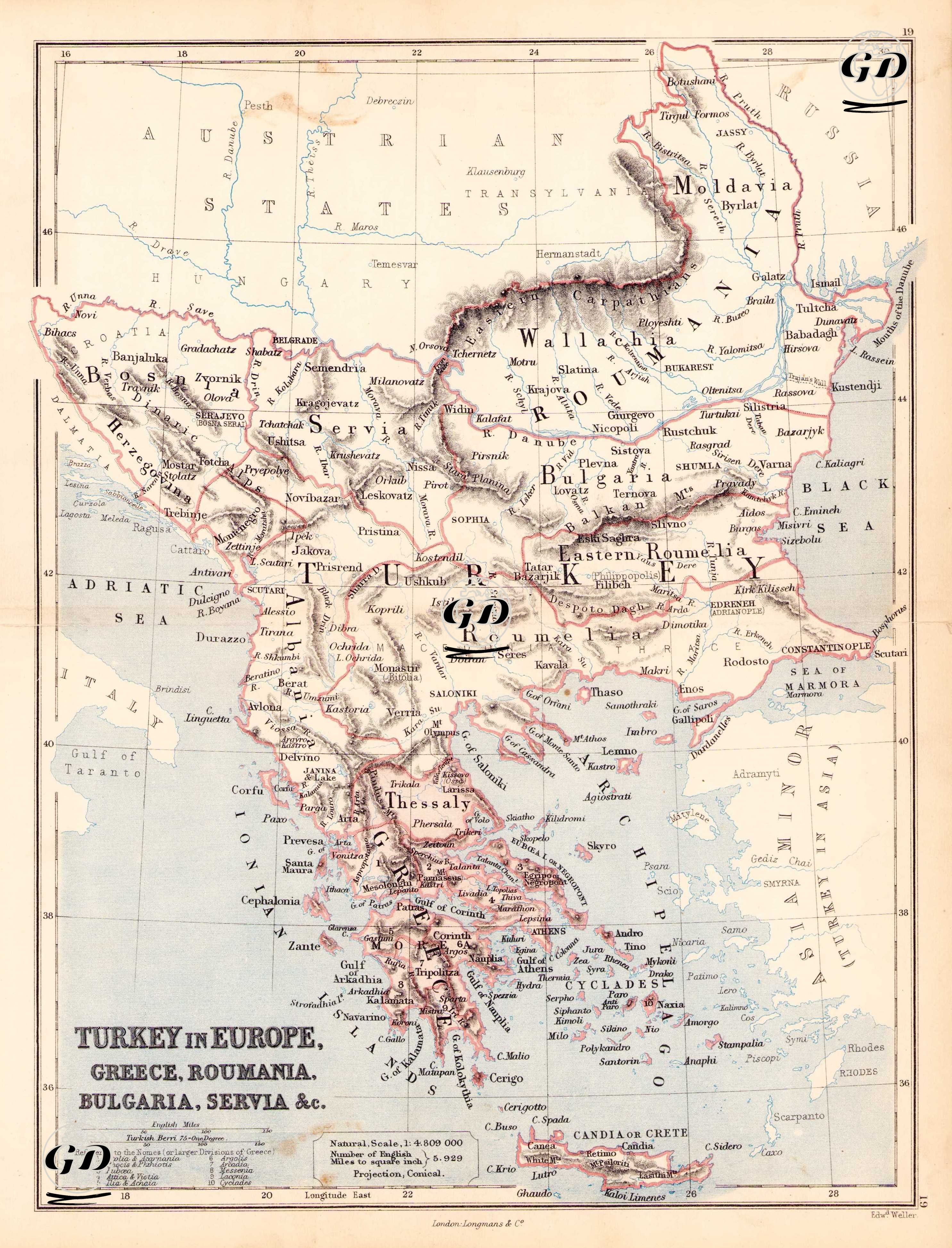
This map dated 1874 reflects in detail the Ottoman Empire's sphere of influence in the Balkans and the new nation-state structures gradually emerging there. The rise of nationalist movements in the Balkans and the disintegration of Ottoman rule as the last quarter of the 19th century approached can be clearly observed on this map. The southern borders of the Austrian Empire are designated as the "Austrian States," while in the northeast, adjacent to the Russian Empire, designated "Russia," are detailed entities such as Moldavia and Wallachia, which were unified in 1859 to form the Principality of Romania. Terms such as "Eastern Rumelia" and "Bulgaria" were used to distinguish the ethnic and administrative differences of these regions, which had not yet gained formal autonomy before the Treaty of Berlin. Regions such as Serbia (Servia), Montenegro (Bosnia), Albania (Albania), Macedonia (Macedonia), and Thessaly (Thessaly) are geographically defined but their political independence is not yet established. Greece, on the other hand, appears as a nation-state that gradually expanded its territory after gaining independence in 1830, and its southern borders are detailed with sections such as the Peloponnese, Attica and the Cyclades. Crete (Crete or Candia), despite still being under Ottoman rule at the time, is highlighted separately on the map, bearing signs of future rebellions and political crises. The Eastern Aegean islands, port cities and trade centers such as Rodosto (Tekirdağ), Dedeağaç, Thessaloniki (Salonik) and Kavala are marked; the map also includes geographical features (mountains, rivers, coasts) and transportation routes. This map, prepared with a conical projection, is scaled with the phrase “1:4,800,000” and equipped with units of measurement based on the English mile. The measurement systems used and projection information are detailed in the lower left corner of the map; Terminology specific to the Western world of the period (“Archipelago”, “Sea of Marmora”, “Gulf of Taranto”) was used in sea naming. Genel olarak bu harita, Osmanlı’nın 1870’lerdeki Avrupa topraklarını belgelemekle kalmayıp, aynı zamanda Osmanlı-Balkan sınırlarındaki etnik, siyasi ve coğrafi karmaşayı yansıtmaktadır.