GRAVÜR DÜNYASI
Digital Engraving Library
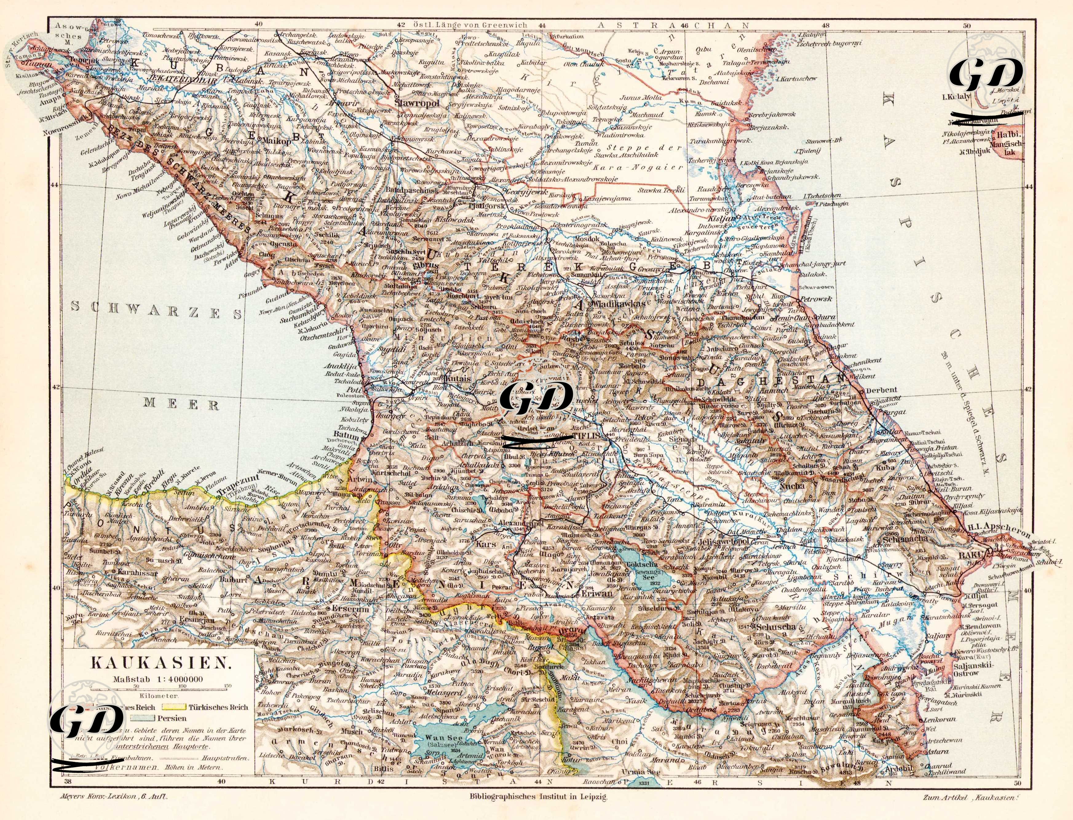
| Date | 1895 |
| Technique | Chromolithograph |
| Category | Maps |
| Source | Meyers Konversations-Lexikon, 6. Auflage - Bibliographisches Institut in Leipzig |
This map, titled "Kaukasien-Caucasian," was published around 1895 in the 6th edition of Meyers Konversations-Lexikon by the Bibliographisches Institut in Germany. The map covers the Caucasus region extending from the Black Sea to the Caspian Sea and includes the lands of present-day Georgia, Armenia, Azerbaijan, northeastern Turkey, and southern Russia. The legend in the lower corner of the map indicates both scale information (1:4,000,000) and the political meaning of the colors used on the map: Lands belonging to the Russian Empire are outlined in pink, Ottoman lands in yellow, and the Iranian borders in light blue. These color divisions clearly illustrate the spheres of influence of the three great empires in the Caucasus. The map centers on the lands of Georgia, Armenia, and Azerbaijan; to the west lie the Black Sea (Schwarzes Meer), to the east the Caspian Sea (Kaspisches Meer), to the north the Kuban and Astrakhan, and to the south Lake Van and Urmia. It is delimited by reference points such as Lake. Cities and geographical elements in the region are depicted with German names: For example, centers such as Tbilisi, Yerevan, Baku, Kars, Ardahan, Gjumri (Alexandropol), and Nachitschewan (Nakhchivan) are shown in detail. The map depicts both natural elements (mountain ranges, river systems, lakes, and valleys) and political administrative divisions (provinces, sanjaks, and provincial borders), and includes railway lines, military outposts, and roads. The Caucasus Mountains are depicted as a spine separating Chechnya and Dagestan in the North Caucasus, and Georgia and Armenia in the South Caucasus, while important rivers such as the Aras and Kura Rivers define the region's topography. Furthermore, after the Russians seized regions such as Kars, Ardahan, and Batumi from the Ottoman Empire with the 1878 Treaty of Berlin, these areas were shown on the map within the borders of the Russian Empire. The details of this strategic region, located at the intersection of three major empires (Ottoman, Russian, and Iranian), reflect the geopolitical tensions and border policies of the period. Therefore, this map reveals both the political map of the 19th-century Caucasus and geographical imaginations encoded by European perspectives. Meyers Konversations-Lexikon, in which this map was published, is one of the most respected and widely used encyclopedias in Germany, published from 1839 to 1984.