GRAVÜR DÜNYASI
Digital Engraving Library
| Date | 1878 |
| Technique | Lithography-Colored |
| Category | Maps |
| Source | The Collegiate Atlas - William Collins Sons & Co. Limited, Glasgow & London |
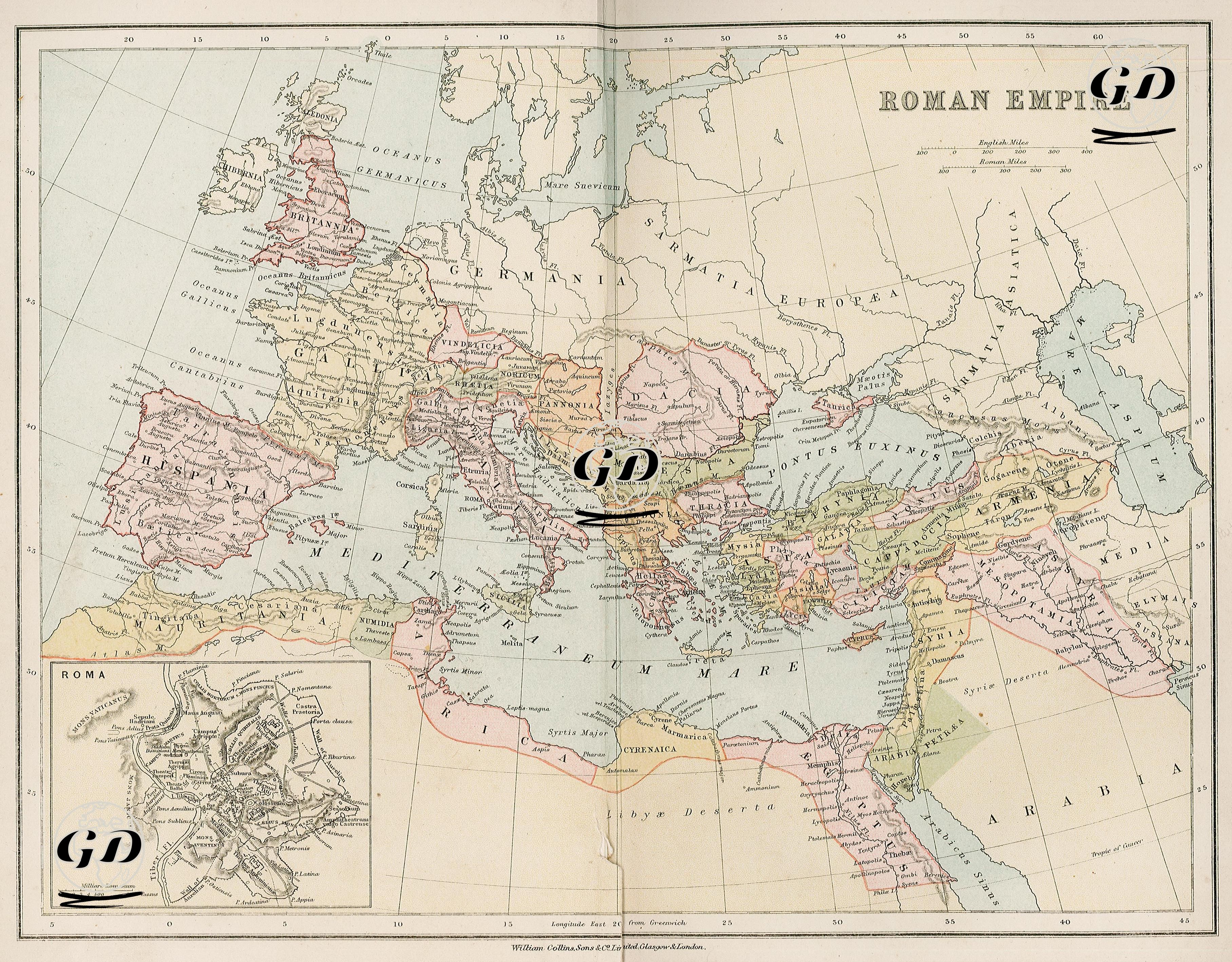
This map depicts the period when the Roman Empire reached its greatest extent and was prepared in classical antiquity. It depicts an empire stretching from the southern British Isles to the west, Hispania (Spain), along the Rhine River to the north, the Germanic borderland to the east, Mesopotamia and Armenia to the east, and along the coastline of North Africa to Egypt in the south. All regions on the map are designated by Roman-era Latin names; for example, present-day France is designated as "Gallia," Spain as "Hispania," and Turkey as "Asia," "Cilicia," "Galatia," "Cappadocia," "Armenia Minor," and "Pontus." One of the striking elements of the map is that the Rhine and Danube rivers are accepted as natural borders in the north, and the peoples beyond this border are defined as non-Roman "barbarian" tribes: regions such as "Germania", "Sarmatia", and "Scythia" are areas outside the direct rule of Rome. The term "Sarmatia," located in the northeast of the map, was used in the ancient world to describe the vast steppe region stretching from the northern Black Sea to the Baltic Sea and east to the Caspian Sea. This name derives from the Sarmatians, a nomadic people of Iranian origin who gave the region its name. In Roman sources, the Sarmatians are mentioned alongside nomadic tribes such as the Alans, Roxolans, and Scythians; they were particularly renowned for their mounted warrior qualities. On ancient maps, Sarmatia Europaea (European Sarmatia) encompassed present-day Poland, Ukraine, and Belarus, while Sarmatia Asiatica (Asian Sarmatia) corresponded to the steppes between the Don and Volga Rivers—in other words, the interior of present-day southern Russia and northern Kazakhstan. This region was seen as a semi-legendary realm beyond the eastern and northeastern borders of the Roman world, and was gradually shaped by new powers such as the Huns and Slavs. The detailed naming of this region on the map reveals not only the geographical knowledge of the time but also the imaginative limitations of the non-Roman world. Additionally, Egypt is shown as “Aegyptus” in the south and is detailed down to the Nile Delta. Similarly, Palestine is represented by ancient names such as "Judaea," "Samaria," and "Galilee." In the lower left corner of the map is a topographic plan of the Roman city. This plan shows the major temples, forums, theaters, and imperial buildings of the period.