GRAVÜR DÜNYASI
Digital Engraving Library
| Date | 1878 |
| Technique | Lithography-Colored |
| Category | Maps |
| Source | The Collegiate Atlas - William Collins Sons & Co. Limited, Glasgow & London |
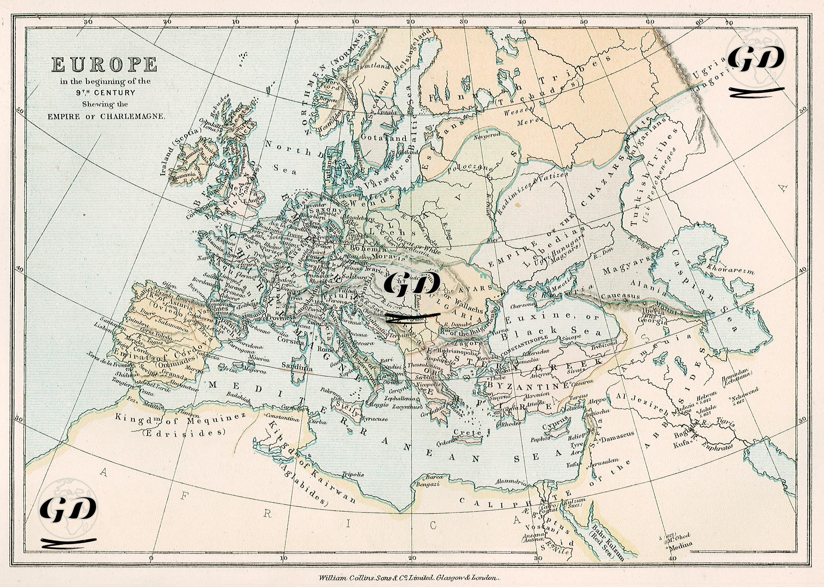
This map shows in detail the political structure of Europe in the early 9th century, and particularly the borders of the Carolingian Empire during the reign of Charlemagne. At the center of the map is the Carolingian Empire, founded in 800 by Charlemagne, the great ruler of the Franks, and considered the forerunner of the "Holy Roman Empire." This empire encompassed much of present-day France, Germany, the Netherlands, Belgium, Switzerland, northern Italy, and western Central Europe. While Aachen stands out as the capital, this vast region is demarcated from other political entities on the map by thick borders. Among the ethnic and political elements clearly marked on the map to the east of the Carolingian Empire are peoples such as the Bohemians, Slavic tribes, Huns, Khazars, Magyars, Bulgars, and Magyars. The names of these groups are written over large, unconventional areas; This strikingly reflects the political and cultural differences between the West and the East in Europe. In the southeast of the map, the Byzantine (Eastern Roman) Empire still maintains a strong presence; Constantinople occupies a central position in the east of the map, and Byzantine influence extends to the Balkans, the Aegean Islands, western Anatolia, Syria, and southern Italy. In the west of the map, the Emirate of Cordoba, successor to the Umayyad Empire of Andalusia, is marked on the Iberian Peninsula. The "Kingdom of Mexico (Idrissides)" is shown on the North African coast, indicating the influence of local Islamic dynasties after the Umayyads. The map also shows the Arabian Peninsula, the eastern borders of the Abbasid Caliphate, Turkic tribes, and communities such as the Khazars, demonstrating the influence of Islamic geography on early medieval Europe at the border level. The term "Turkish Tribes" on the map refers to the ethnic and geographic presence of Turkic tribes in Central Asia after the Gokturks in the early 9th century. This usage on the map is quite abstract and broad; It does not refer to a specific Turkish state, but rather to the areas where Turkish tribes generally settled. The map, its color coding, and its border drawings clearly illustrate the balance of power in the period when early 9th-century Europe, while fragmented, began to coalesce around major centers of power. Charlemagne's imperial borders reflect not only a sovereign territory but also the geographical projection of a cultural claim representing the protective power of Christianity in the West and the reconstitution of Roman heritage. In this context, the map cartographically brings together both the emergence of a Frankish medieval Europe and its power relations with Byzantium to the east and the Islamic world to the south.