GRAVÜR DÜNYASI
Digital Engraving Library
| Artist | Ernst George Ravenstein (1834-1913) |
| Engraver | Ernst George Ravenstein (1834-1913) |
| Date | 1878 |
| Technique | Woodblock Engraving (Newspaper-Text on Reverse) |
| Category | Maps |
| Source | The İllustrated London News (February 09 1878-Page 134) |
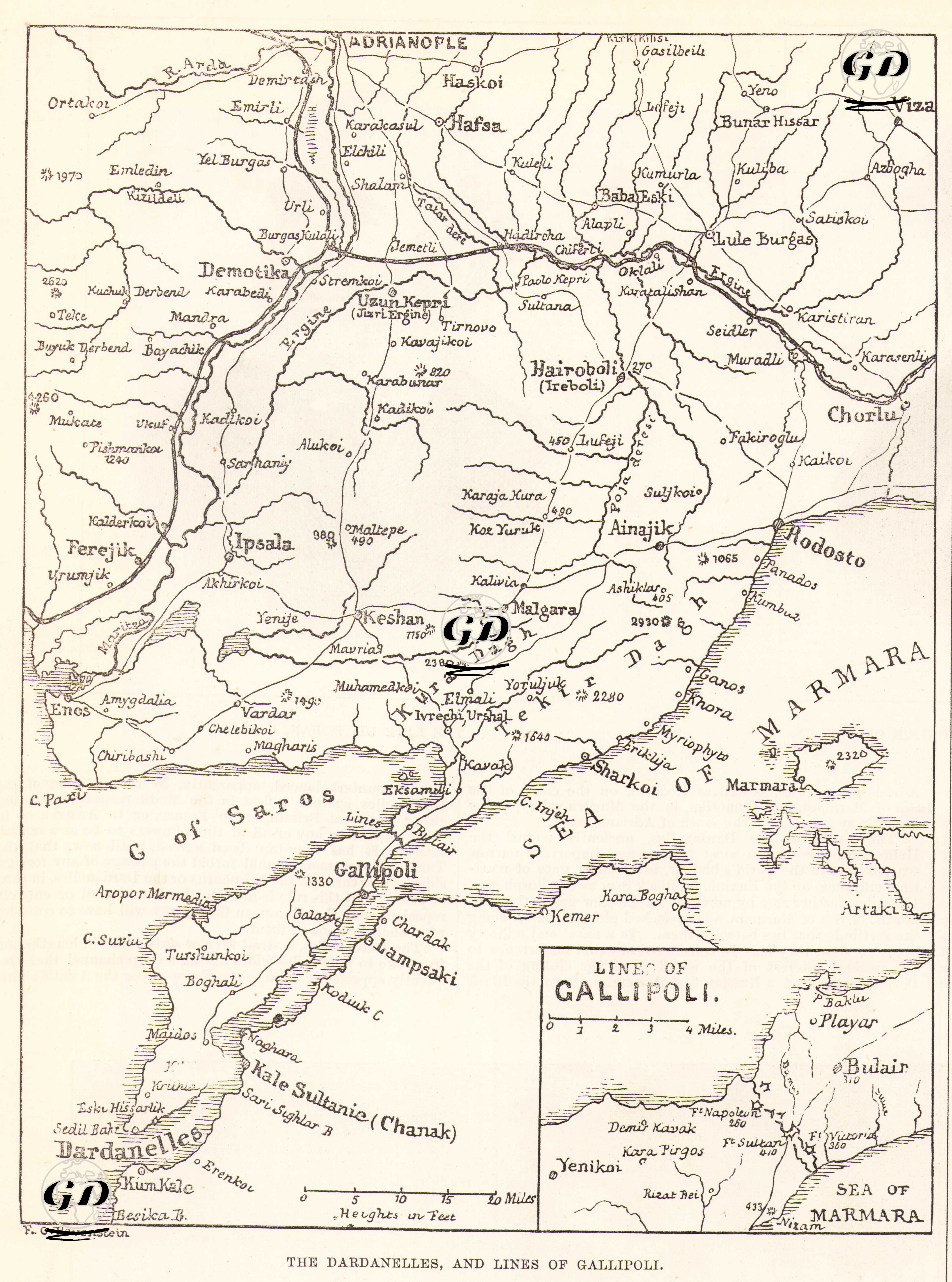
The map and the article about it, titled "The Dardanelles, and Lines of Gallipoli - Map of the Dardanelles and the Gallipoli Railway", published in The Illustrated London News on February 9, 1878, comprehensively introduce the Dardanelles and the Gallipoli Peninsula, strategically important regions of the Ottoman Empire in Europe. The map was drawn by Ernst George Ravenstein (1834-1913), one of the important cartographers of the period. The map shows in detail the Thracian cities of Demotika, Keşan, İpsala, Rodosto (Tekirdağ), Malgara and Enos, starting with the settlements in Edirne (Adrianople) and its vicinity. It also presents a settlement network detailing the strait crossing points such as the Gallipoli Peninsula, Dardanelles (Dardanelles), Seddülbahir, Kilitbahir and Çanakkale (Kala Sultanie/Chanak). The map centres on the heights, roads, hills, fortresses on the Bosphorus and important military positions in the Gallipoli region. In addition, the small box map at the bottom of the map (“Lines of Gallipoli”) provides a more focused military plan; this plan shows the defensive positions, forts and artillery emplacements on the Gallipoli line. The newspaper article emphasizes the historical importance of the Dardanelles Strait, its position as the main passage connecting the Black Sea to the Mediterranean, and the strategic interests of England and European states in this region, and states that the straits were the last important defense lines of the Ottoman Empire on the European continent, and played a role in preventing a Russian fleet from entering the Mediterranean. At the same time, attention is drawn to the vitality of controlling the Gallipoli Peninsula in the event of war, with its geographical structure, narrow passages and hills suitable for defense. In addition, the fact that the railway connections extend from Edirne to Tekirdağ (Rodosto) and the Gallipoli line is seen as important in terms of the Ottomans’ shipping capabilities. The article generally emphasizes the Ottoman Empire’s loss of power in the Balkans and the increasing geopolitical value of the straits in the eyes of Western powers with the Russian advance.