GRAVÜR DÜNYASI
Digital Engraving Library
| Date | 1878 |
| Technique | Lithography-Colored |
| Category | Maps |
| Source | The Collegiate Atlas - William Collins Sons & Co. Limited, Glasgow & London |
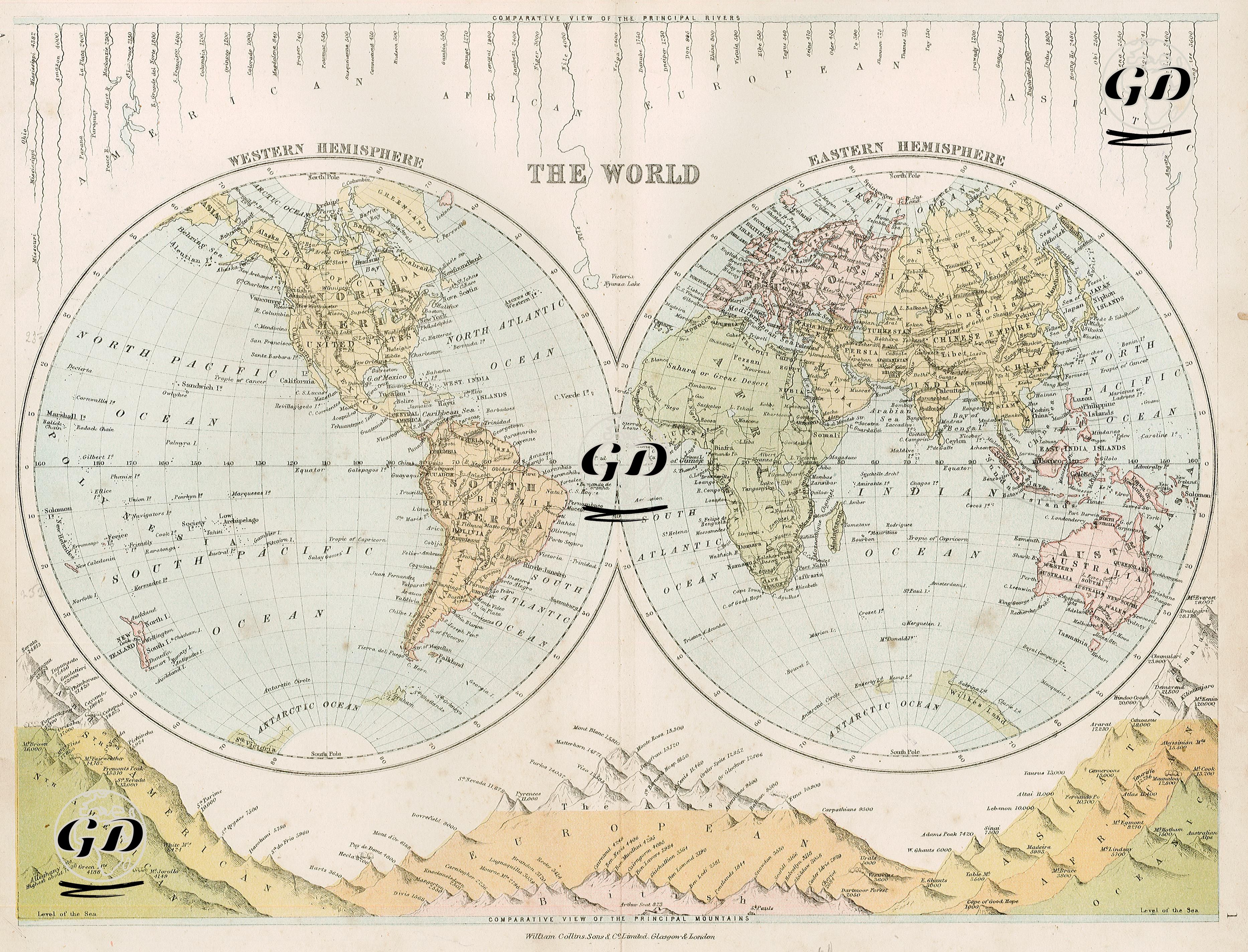
This image is a world map from the second half of the 19th century, prepared using a dual spherical projection showing the Western and Eastern Hemispheres in two separate circles. The bottom of the map, quite strikingly, features a comparative cross-section (profile view) of the world's major mountain ranges. The top edge features the comparative lengths of the world's major rivers. This multilayered structure transforms the map from a mere political map into a geophysical and visual encyclopedic atlas. The publisher is identified in the bottom margin as "William Collins Sons & Co., Limited, Glasgow & London," a prominent British publishing house known for its geography, biblical, and atlas printing during the 19th century. The center of the map features globe maps. The left globe includes the American continents (Northern and Southern), the Atlantic and Pacific oceans, and the Antarctic region, while the right globe includes the Eastern Hemisphere, which includes Europe, Asia, Africa, Australia, and the islands. The maps detail colonial empires, settlement areas, some exploration routes, and island groups according to the geographical and political knowledge of the period. The Ottoman Empire was referred to as "Turkey" and "Turkey in Asia" on the continents of Asia and Europe. While India is shown as "British India," Africa is largely still "undiscovered" or consists of regions named after tribes. At the bottom of the map, the world's mountains are arranged horizontally according to their heights; the Andes, the Himalayas, the Alps, Ararat, Etna, and Vesuvius. Mountain peaks are drawn comparatively. It is seen both that mountain ranges are divided according to geographical regions and that heights are measured using the metric system. This graphical representation is a didactic form used in 19th-century cartography to visualize natural history. At the top of the map, rivers such as the Amazon, Nile, Mississippi, Volga, Danube, and Ganges are shown, starting with the longest; Each of them is extended as a line and the continent it is on is specified, the slope of the rivers and their source-mouth structures are presented in an abstract manner in this section. Such maps are early modern information tools used for the visual and comparative teaching of geography.