GRAVÜR DÜNYASI
Digital Engraving Library
| Date | 1876 |
| Technique | Woodblock Engraving (Newspaper-Text on Reverse) |
| Category | Maps |
| Source | The Graphic (July 01 1876-Page 5) |
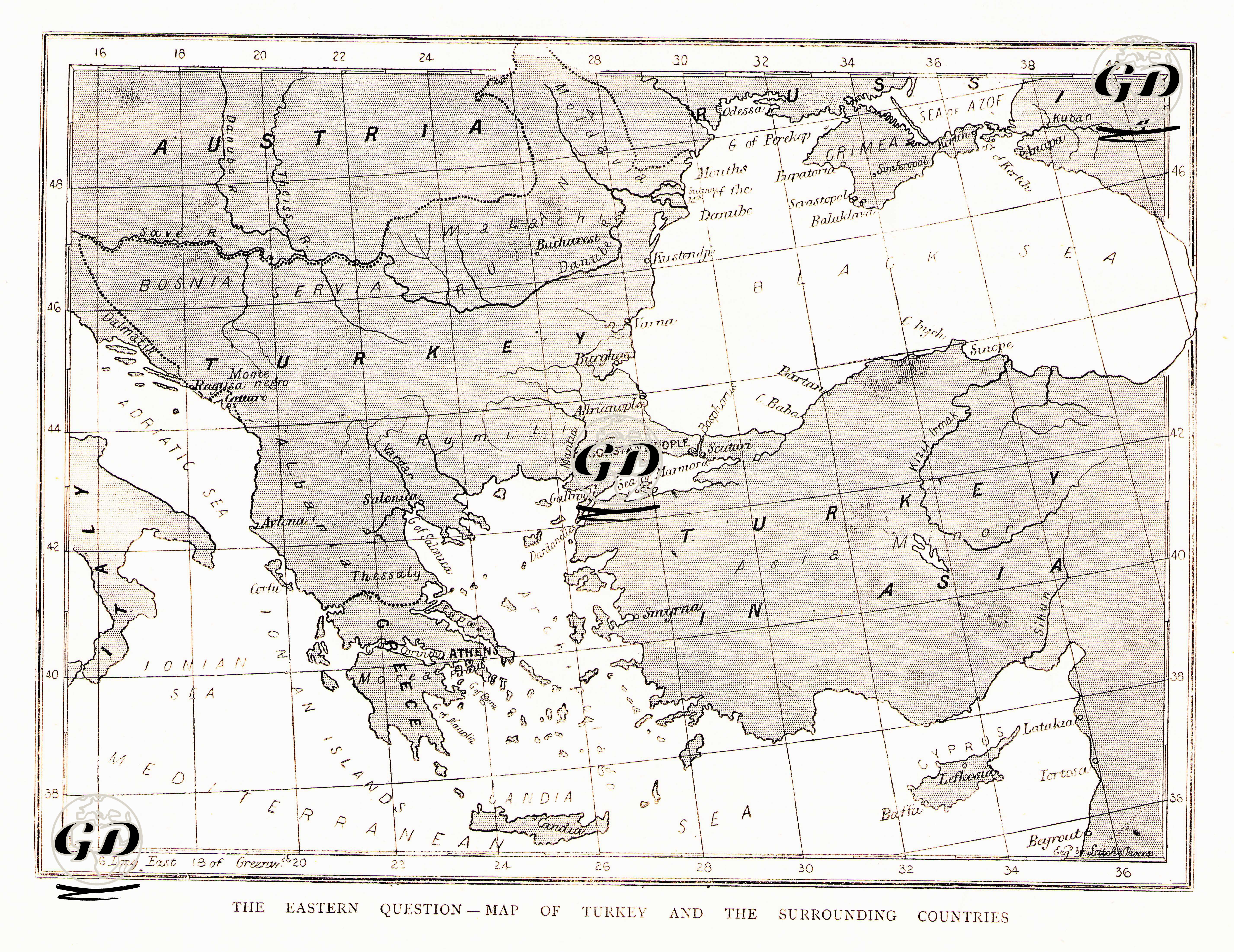
The article and map titled “The Eastern Question – Map of Turkey and Her Dependencies” published in The Graphic newspaper on July 1, 1876, provides a comprehensive geopolitical analysis of the political-territorial integrity of the Ottoman Empire in the Balkans, Anatolia and the Middle East. The map is a political representation of the lands that the Ottoman Empire possessed as of 1876 and the countries around it. Along with the Balkans, Anatolia, Mesopotamia and the Middle East, states that had direct political, military or border contact with the Ottoman Empire, such as Greece, Russia, Austria and Iran, are also shown. While the administrative structure of the Ottoman Empire on a continental scale is emphasized on the map with the titles “Turkey in Europe” and “Turkey in Asia”, distant but symbolically connected lands such as Cyprus, Egypt and Tripoli are also shown as part of the Ottoman geography. The article also comments on the political instabilities, nationalist rebellions and the intervention of the great powers (Russia, Austria-Hungary, England and France) experienced in these lands. It particularly emphasizes the uprisings in Bosnia-Herzegovina, the Bulgarian rebellion and Serbia-Montenegro preparing for war against the Ottomans, and describes how the Ottomans' weakening central authority, insufficient financial resources and scattered army were struggling to keep the empire on its feet. The article states that the Ottomans were weakened militarily and had difficulty fighting the uprisings both in the Balkans and in the East. It states that the Turkish army was "poorly trained, disorganized and underpaid" and in a financially collapsed state, and therefore military reforms were unsuccessful. However, it also points out how this situation presented a strategic opportunity for the great powers of Europe: Russia's influence over the Balkan Slavs, Austria's demands over Bosnia and England's interests in the Mediterranean and the Suez Canal. When the map and the text are evaluated together, it is seen that the Ottomans' increasingly disintegrating political structure was presented to the European public opinion as a "regulatory and guiding intervention." In this context, when the map is evaluated together with its news, it reflects the area of power struggle that would occur in Europe towards the Ottomans in the last quarter of the 19th century.