GRAVÜR DÜNYASI
Digital Engraving Library
| Artist | Claude Joseph Drioux (1820-1898)-Charles Leroy |
| Engraver | Jenotte |
| Date | 1872 |
| Technique | Steel Engraving-Original Hand Colored |
| Category | Maps |
| Source | Atlas Universel et Classique de Geographie - Librairie Classique Eugene Belin a Paris |
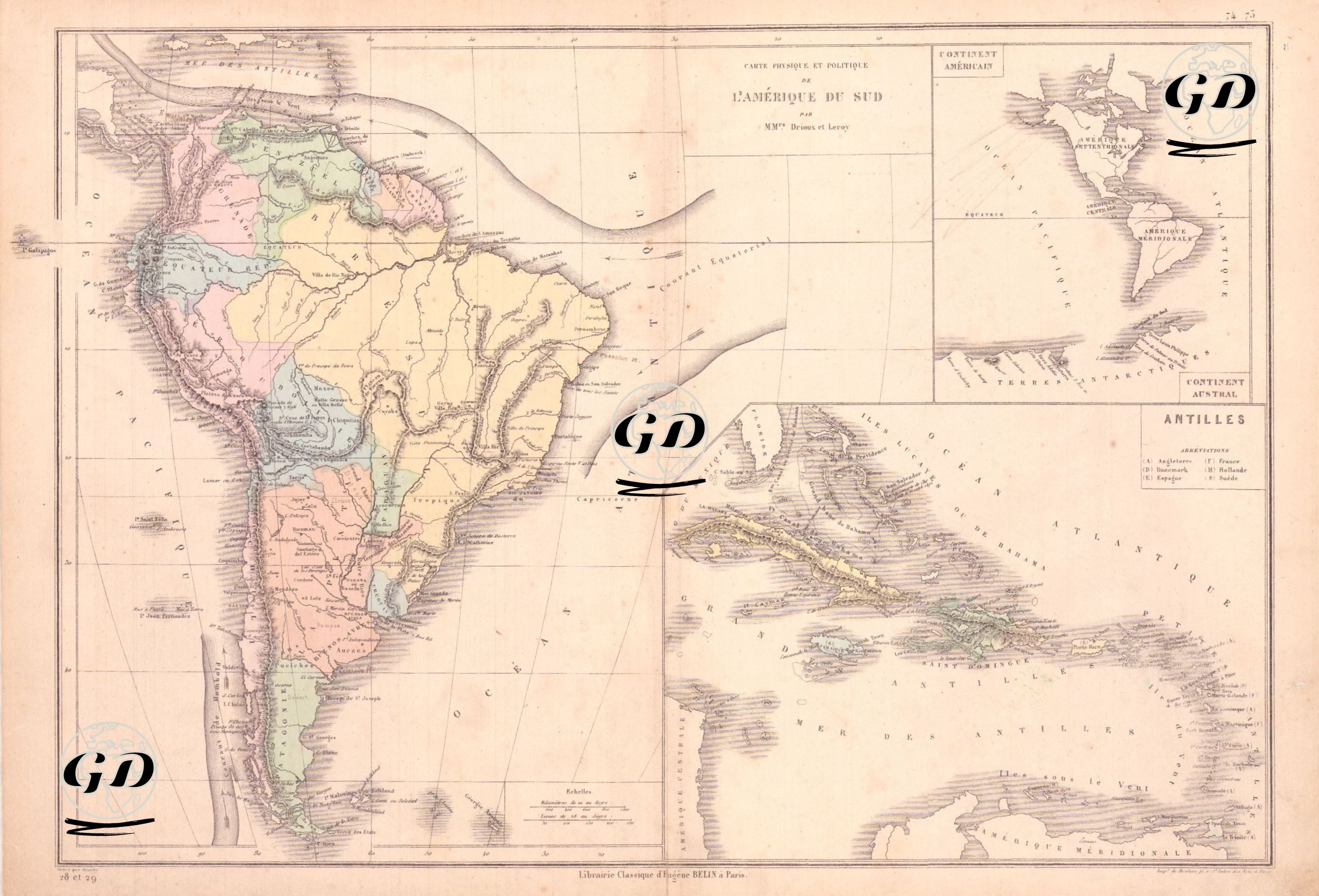
This map dated 1872 depicts both the physical geography and political structure of South America in detail. The map is significant in terms of the geopolitical landscape of the 19th century. Because most South American countries gained their independence from Spain and Portugal at the beginning of the 19th century, borders were not yet fully established, and therefore, some regions were drawn to reflect a period of historical transition. Brazil's imperial structure is clearly depicted, while the borders and cities of the Spanish republics are clearly marked, and the areas of European domination throughout the continent continue to be the Caribbean islands and the Guiana regions. The visual emphasis of the equator serves as both an astronomical and geographical reference point. In this respect, the map is not merely a map of political boundaries but also reflects the geomorphological and post-colonial political landscape of South America in the 19th century. The main body of the map depicts all of South America, with political boundaries and country names marked in different colors. Mountain ranges, major rivers, and coastlines are depicted using a detailed topographic raster. The Andes are meticulously rendered as a prominent mountain range rising parallel to the continent's western coast, creating a visual contrast with the eastern plains. The channels of major rivers such as the Amazon, Orinoco, and Rio de la Plata are clearly marked, and the geographic texture of the region's interior is clearly reflected through the river systems. Brazil, with its vast territory, stands out as the largest state on the map, and important inland regions and port cities such as Rio Janeiro, Bahia, Pernambuco, and Mato Grosso are shown. In southern Brazil, the regions corresponding to present-day Argentina have not yet been designated as "Republique Argentine"; instead, they include La Plata and Patagoniaine. Paraguay and Uruguay are also designated as independent political units. On the west coast of the continent, Chile extends north-south along a narrow coastline, with Santiago as its capital; north of Chile, Peru, and east of it, Bolivia are presented as separate states. Ecuador is defined by the city of Quito, and to the north, a large region called New Granada (Nouvelle-Grenade) encompassing present-day Colombia and Panama is shown on the map. In the northeast of the map, on the Atlantic coast, the Guyanes (regions of Guyana) are shown collectively; of these, Guyane Anglaise (British Guiana - modern-day Guyana), Guyane Hollandaise (Dutch Guiana - modern-day Suriname), and Guyane Française (French Guiana - modern-day French territory) are clearly distinguished. In the lower right corner of the map, a map of the Antilles (Caribbean) is displayed, indicating such major islands as Cuba, Jamaica, Hispaniola (divided into Santo Domingo and Haiti), and Puerto Rico, as well as French islands such as Guadeloupe and Martinique; A table of signs is also added showing which colonial power the islands belonged to: (1) English (Angleterre), (2) French, (3) Dutch, (4) Spanish. In the upper right corner of the map, there is a small-scale inset showing the general geographic location of South America, along with North America and Antarctica. Another important aspect of the map is its depiction of ocean currents. Specifically, in the Atlantic Ocean, a current parallel to the equator, known as the "Equatorial Current," is marked with an arrow pointing east to west. This represents a warm water current originating off the coast of Africa and heading northeastward to South America (especially the coast of Brazil). The Equatorial Current played a significant role in shaping tropical climate systems, rainfall patterns, shipping routes, and trade routes, particularly influencing the routes of ships arriving from Europe during the colonial era.