GRAVÜR DÜNYASI
Digital Engraving Library
| Artist | Claude Joseph Drioux (1820-1898)-Charles Leroy |
| Engraver | Jenotte |
| Date | 1870 |
| Technique | Steel Engraving-Original Hand Colored |
| Category | Maps |
| Source | Atlas Universel et Classique de Geographie - Librairie Classique Eugene Belin a Paris |
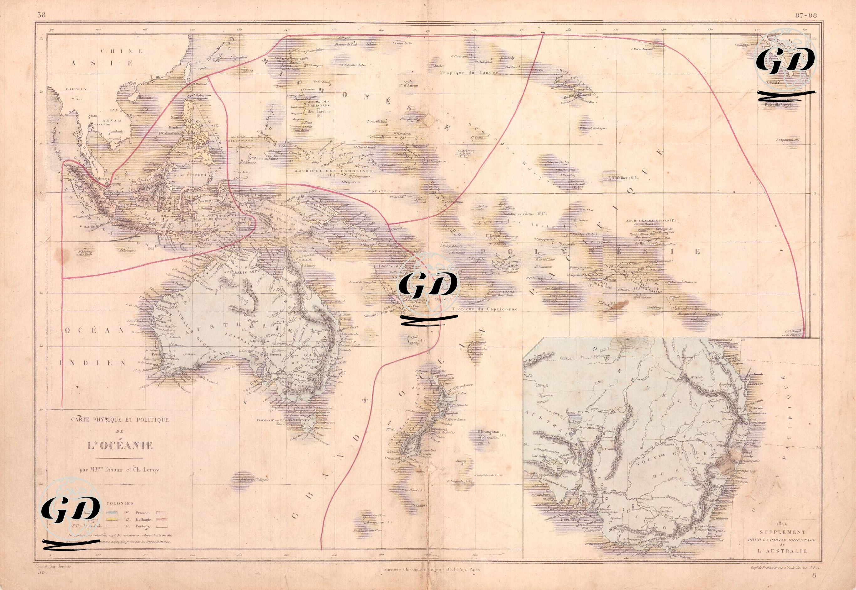
This 1870 map, titled "Carte Physique et Politique de l’Océanie," depicts the continent of Oceania and the geography of the Pacific from both political and physical perspectives. This French map aims to visualize the dominance of European colonial powers over this vast region in the second half of the 19th century, taking into account both physical and political characteristics. The map covers a vast geography extending from the Australian continent to the Southeast Asian archipelago, Polynesia, Melanesia, and Micronesia. A large-scale "Supplement pour la Partie Méridionale de l’Australie" (Supplementary map for the southern part of Australia) is also displayed in the lower right corner, showing the interior of Australia in greater detail. The colored legend at the bottom of the main map indicates which islands were dominated by powers such as Britain, France, the Netherlands, Spain, and Portugal, and the relevant areas on the map are color-coded. 1. England; Australia, New Zealand, Fiji, eastern New Guinea, and some Polynesian islands. 2. France; Tahiti, New Caledonia, and the Marquesas Islands. 3. Netherlands; the Indonesian Archipelago (especially Java, Sumatra, and southern Borneo). 4. Spain; Guam and the Caroline Islands. 5. Portugal; eastern Timor Island. The colonial influence of European powers can be clearly traced on the map through color coding. However, the map is enriched not only with political borders but also with sea routes and geographic transitions. Broad lines marked in red are placed to indicate the period's maritime trade routes and areas of colonial influence. These lines extend from India and Southeast Asia, through the Strait of Malacca, to the Java Sea, and from there to New Guinea, the Solomon Islands, and the Marquesas. Climatic boundaries are also indicated on the map, along with lines of latitude such as the "Tropique du Capricorne" and "Équateur." The Australian continent is located in the centre of the map, with port cities (Sydney, Melbourne, Adelaide, Hobart) and major river systems (especially the Murray and Darling Rivers) depicted. The large inset in the lower right corner of the map, titled "Supplement to the Australian Partition," focuses on Australia's southern region. This detailed map enhances the continent's inland area, showing geographical features such as topographic details, rivers, mountains, and inland ports. The presence of settlement gaps and a lack of detail in the Australian interior suggests that the interior is still in the process of exploration and settlement. The map also references large island clusters and ethnogeographic regions such as Polynesia (Tahiti, Tonga, Hawaii, Samoa), Melanesia (Fiji, New Caledonia, Papua New Guinea), and Micronesia (Mariana, Caroline, and Gilbert Islands). These regions were classified as products of the Eurocentric geographic information system, assuming homogeneous cultural structures within the island chains. For example, the Sandwich Islands (modern-day Hawaii) are shown in small font in the northwest of the map, indicating their location within this system.