GRAVÜR DÜNYASI
Digital Engraving Library
| Artist | J.J.Hellert |
| Engraver | U.Muschani |
| Date | 1844 |
| Technique | Steel Engraving |
| Category | Maps |
| Source | Nouvel atlas physique, politique, et historique de l'Empire Ottoman et des etats limitrophes en Europe, en Asie et en Afrique... -Imprimee chez Thierry Freres (New political and historical atlas of the Ottoman Empire and neighboring states in Europe, Asia and Africa, in forty sheets) |
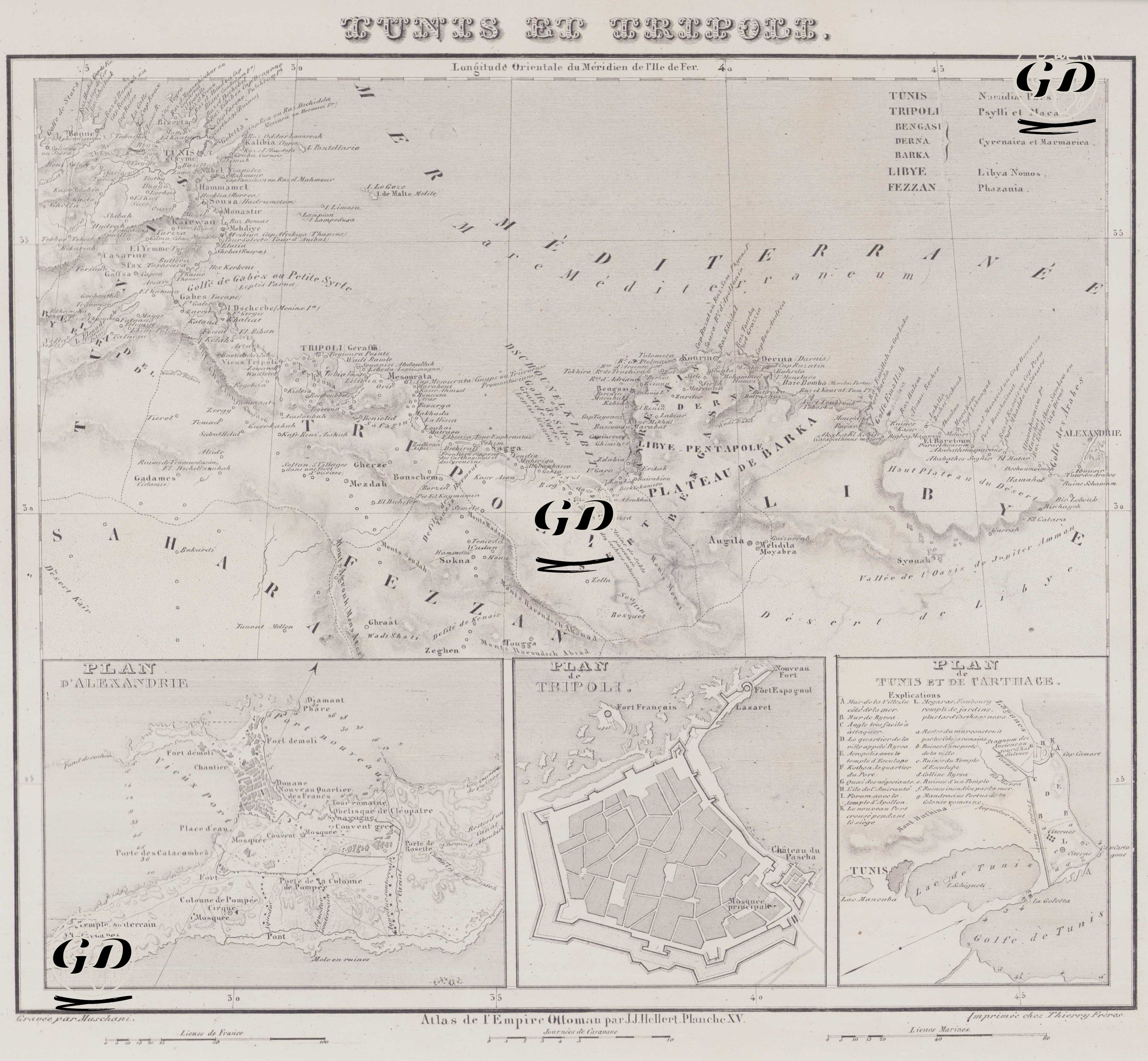
This map dated 1844 covers the Ottoman Empire's territories in North Africa, focusing particularly on the provinces of Tunis and Tripoli. This cartographic work, combining both geographical and historical city plans, was prepared in French and provides a detailed view of the Ottoman provincial administration in Africa, coastal cities, ancient city ruins, and physical structure. The map consists of three main sections: a large regional map at the top, and three separate city plans depicting Alexandria, Tripoli, and Tunis et Carthage. The general map at the top extends from the Algerian border in the west to Egypt in the east. To the north, the cities, ports, and ancient ruins along the Mediterranean coast are shown in detail. The map features a mix of ancient and modern settlement names, including "Tripoli de Barbarie," "Tunis," "Leptis Magna," "Cyrene," "Benghazi," "Derna," and "Alexandrie." Regions are listed in the upper right corner under titles such as Tunis, Tripoli, Bengasi, Berenice Barca, Libye, and Fezzan. These titles refer not only to geographical regions but also to ancient designations: for example, the phrase "Pentapole de Barca" refers to five ancient Greek cities (Pentapolis) in the Cyrenaica region. The map carefully marks modern settlements, as well as ancient city ruins such as "Ruines de Sabrata," "Ruines de Leptis," and "Ruines de Cyrene." Desert areas such as "Desert de Barca" and "Desert de Libye" are also indicated. Tripoli is at the center of the map, and elements such as roads extending north-south into the Fezzan region, tribal areas (Beni Uled, Garian, etc.), mountain ranges (Djebel Gharian, Djebel Nafousa), and oases (Ghadames, Sokna) are carefully marked. This is valuable in illustrating the Ottoman spheres of control extending from the central coastal cities to the desert polities in the interior. The three city plans in the lower section are among the map's unique features: 1. Plan d'Alexandrie (Alexandria): Located on the western Egyptian coast, Alexandria's detailed port structure, fortresses, port facilities, marshes, and ancient structures are depicted. Particular emphasis is placed on landmarks such as the Phare (lighthouse) and the Port of Commerce. 2. Plan de Tripoli: The walled city plan of Tripoli is drawn geometrically and symmetrically. The wall lines, gates (Portes), inner neighborhoods, and the harbor are shown. The plan represents one of the most representative examples of Ottoman urban architecture in North Africa. 3. Plan de Tunis et de Carthage: The area surrounding the Gulf of Tunis and the ruins of Carthage are the focal point of this plan. The city of Tunis is marked by important gates such as Bab el-Djazira and Bab Souika, while the Carthaginian region is highlighted by its ancient ruins.