GRAVÜR DÜNYASI
Digital Engraving Library
| Engraver | William Hughes (1818-1876) |
| Date | 1854 |
| Technique | Steel Engraving |
| Category | Maps |
| Source | The Beauties Of The Bosphorus (Published By G.Virtue, London & New York) |
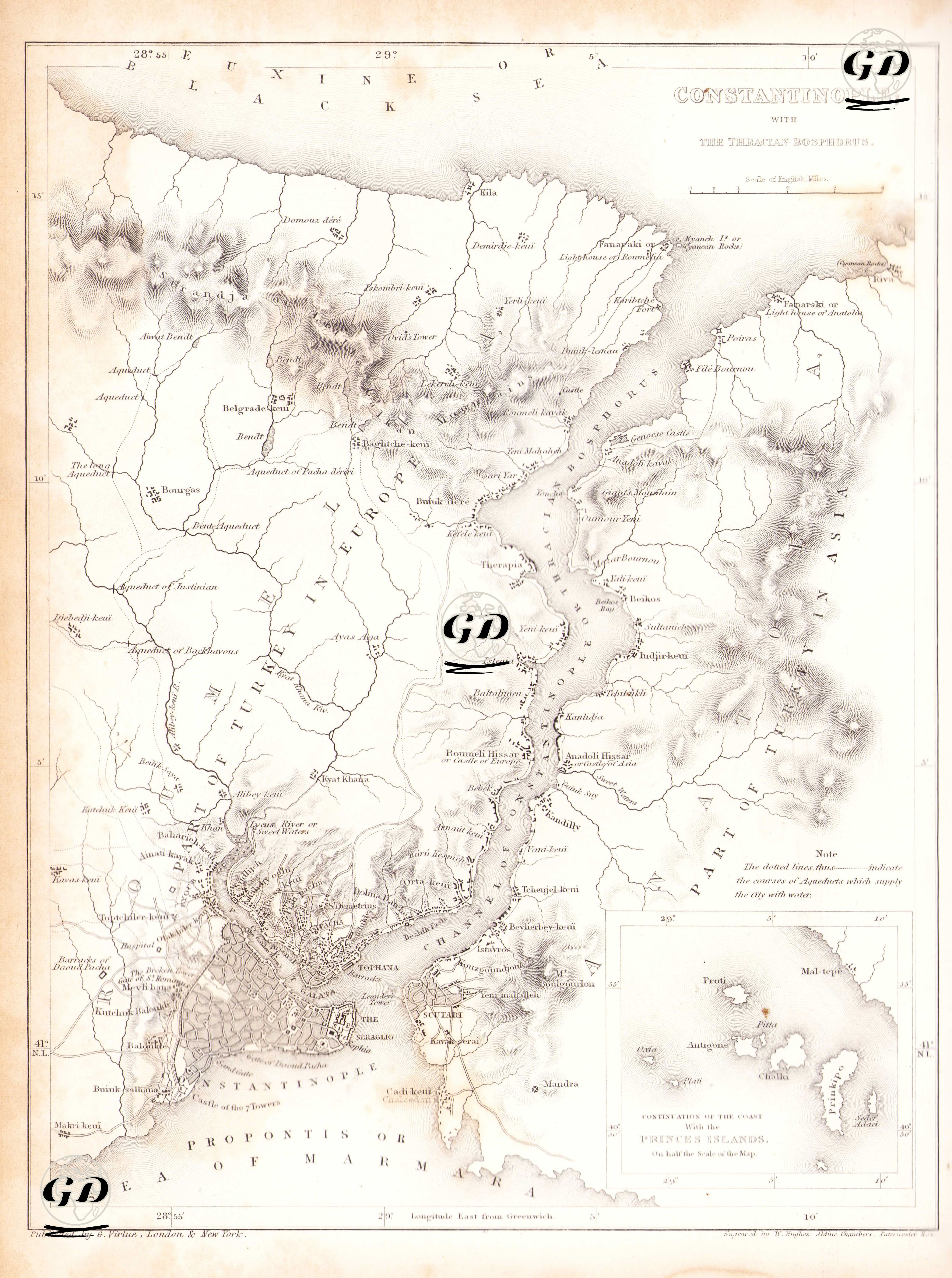
This 1854 map shows the settlements and lands on both banks of the Bosphorus, which extends north from Istanbul to the Black Sea. The map's focus is not only on the city center, but also on the military fortifications along the Bosphorus and the ancient aqueducts (shown with dotted lines). The legend in the lower right corner of the map, "The dotted lines show the course of aqueducts that supply the city with water," highlights the importance of this system in urban infrastructure. These dotted lines represent ancient Roman and Byzantine waterways that carried water from the interior of Thrace to Istanbul. These water sources originate from the dams and dams (such as the Bend-i Cedid and Kirazlı Dam) in and around the Belgrade Forest, and proceed through the Kağıthane Valley, reaching the inner city of Istanbul via Eyüp. There are many monumental structures that still exist on this line today: Bozdoğan Aqueduct (Valens Aqueduct), Uzun Kemer, Gözlüce Kemer, Ballıgerme and Mağlova Kemer are just some of them. This ancient water system fed Istanbul (then known as Constantinople) from the 4th century onward, becoming one of the most advanced infrastructure networks that Roman engineering had ever created for the city. During the Ottoman Empire, these water transportation systems were restored and expanded by Mimar Sinan. The map also shows military defensive structures in detail on both the European and Anatolian sides. Defensive forts are depicted as "forts" or citadels. These forts were strengthened and modernized, particularly in the 18th and 19th centuries, in line with the Ottoman Empire's Bosphorus defense plans. Another striking feature of the map is the extensive depiction of Istanbul's city center. Topkapı Palace, Hagia Sophia, Galata Tower, and the surrounding buildings of the Golden Horn are clearly depicted, and the ancient city walled in by the city is clearly defined. The names of settlements along the Bosphorus are listed from north to south, with settlements such as Kilyos (Kilya), Bahçeköy, Sarıyer, İstinye, Ortaköy, and Beşiktaş listed individually. On the Anatolian side, starting from Şile, settlements such as Paşabahçe, Beykoz, Çengelköy, Üsküdar, and Kadıköy are shown. The inset map in the lower right corner of the map lists the Princes' Islands under the heading "Continuation of the Coast with the Princes' Islands." Büyükada (Prinkipo), Heybeliada, Burgazada, Kınalıada, and other smaller islands are marked with their names.