GRAVÜR DÜNYASI
Digital Engraving Library
| Engraver | Josiah Neele (1804-1876) - James Neele (active 1828-1832) |
| Date | 1831 |
| Technique | Copper Engraving-Original Hand Colored |
| Category | Maps |
| Source | London Published Feb 1 1831 by T.Cadell & the other Proprietors |
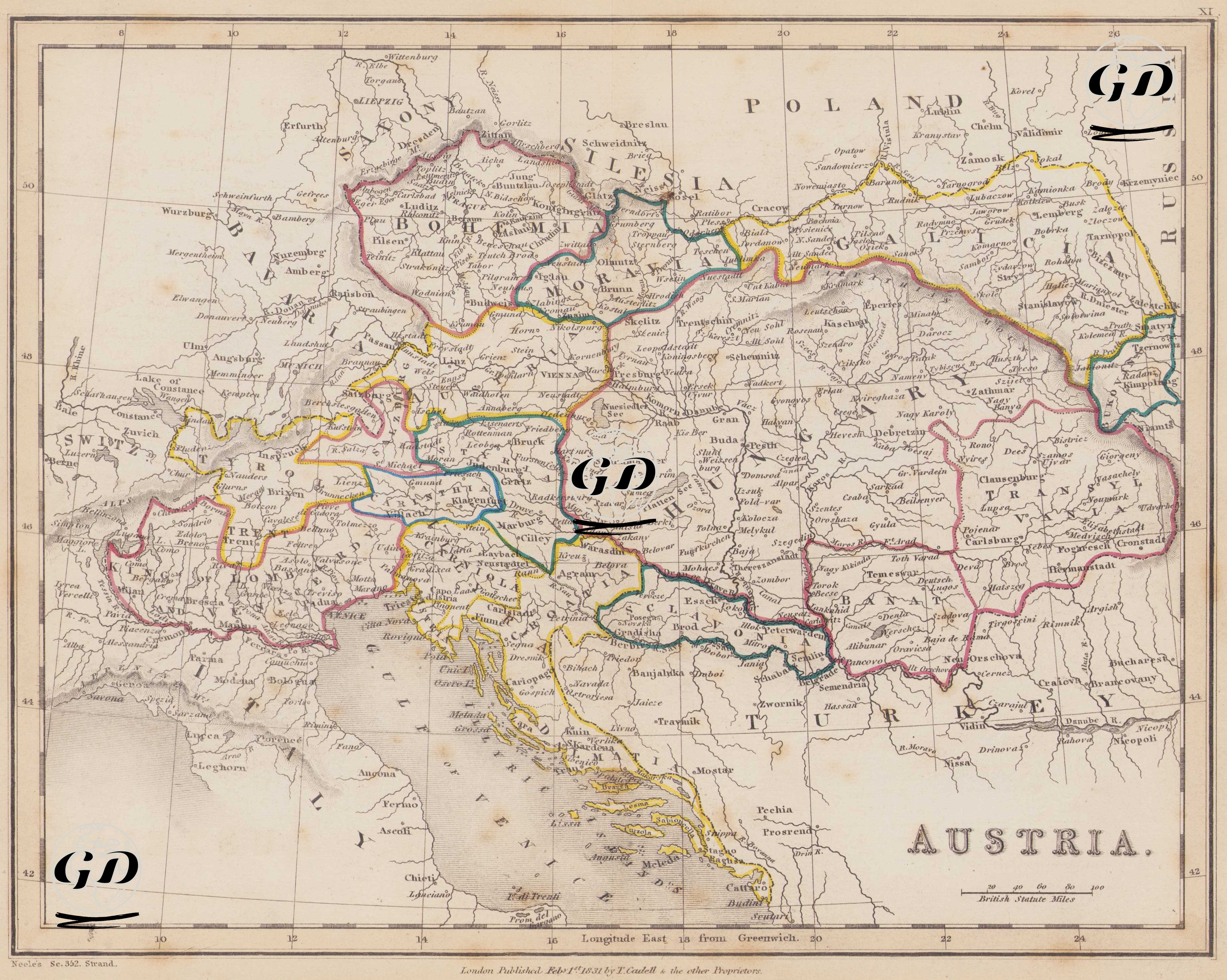
This map dated 1831 depicts the political, geographic, and administrative structure of the Austrian Empire under the Habsburg dynasty. It reflects the border arrangements consolidated by the 1815 Congress of Vienna after the Napoleonic Wars and visualizes the Habsburgs' multinational imperial structure largely through geographical and administrative centers. The core region at the center of the map, clearly labeled "AUSTRIA," represents the central Austrian territories centered in Vienna. Administrative structures that expanded around this region included Bohemia (western part of present-day Czechia), Moravia (eastern part of Czechia), Hungary (Hungary), and Transylvania (western part of present-day Romania). These regions possessed distinct administrative structures and historical backgrounds within the Austrian monarchy, and are notable for their multinational character, where diverse ethnic groups (Germans, Hungarians, Czechs, Slovaks, and Romanians) lived together. Galicia, shown in the northeast of the map with Lemberg (Lviv) as its center, is an important region that was annexed to Austria after the first partition of Poland in 1772. Galicia held strategic importance both because of its Polish population and because it served as a border region for Eastern Europe. Similarly, the Bukovina region is marked on the map as a small but critical region to the east, located on the present-day Romania-Ukraine border. To the west of the map, the Alpine provinces of Tyrol, Salzburg, Styria, Carinthia, and Carniola stand out. These regions are mountainous and Catholic-populated areas, a legacy of the Habsburgs. The map highlights these regions not only by naming them but also topographically through mountain shading (hachure). In the southeast, the region of Transylvania (Erdely) is clearly named and separated from Hungary. This distinction stems from Transylvania's recognition as a special state at the time. At the southern border of the map lies the Adriatic coast region, designated Dalmatia, where port cities like Ragusa (Dubrovnik) are visible. Dalmatia, as the gateway to the Adriatic, is known to have played a significant role in Habsburg maritime policies. Sclavonia (modern Slavonia) was under Habsburg rule as a vassal of the Hungarian Kingdom in the early 19th century. Slavonia was part of the border defense system (Military Frontier / Vojna Krajina) established against the Ottomans. This region, where Slavic militias were stationed and provided Austrian border security, had both military and agricultural importance. Banat, on the map, is located east of "Sclavonia," around Timișoara (Temeswar), and is directly named. Banat was captured from the Ottomans in 1718 and incorporated into Habsburg Austria. During the 18th century, groups such as Banat Germans (Donauschwaben) were immigrated there, and the region was restructured for agricultural production. The word "TURKEY" on the map, located just beyond Austria's eastern border, on the borders of present-day Serbia, Bosnia, and Romania, refers to the European territories (provinces of Rumelia) under Ottoman rule. In the north of the Italian peninsula, the regions of Lombardy and Venetia are shown within the borders of "Austria" on the map. After the Congress of Vienna in 1815, these two regions were officially left to Austrian administration and remained directly under Austria until the Italian unification process. Cities such as Milan, Verona, and Venice, in particular, are important centers of industry, trade, and culture in both Austrian and European history. Silesia is clearly designated on the map's northern border. Although much of this region was annexed by Prussia in the 18th century, some remained part of Austria. Cartographically, the map is prepared in British Statute Miles, with longitudes indicated according to the Longitude East from Greenwich system. The map highlights mountainous regions through shading and details major river systems (especially the Danube).