GRAVÜR DÜNYASI
Digital Engraving Library
| Artist | Ernst George Ravenstein (1834-1913) |
| Engraver | Ernst George Ravenstein (1834-1913) |
| Date | 1878 |
| Technique | Woodblock Engraving (Newspaper-Text on Reverse) |
| Category | Maps |
| Source | The İllustrated London News (March 16 1878-Page 250) |
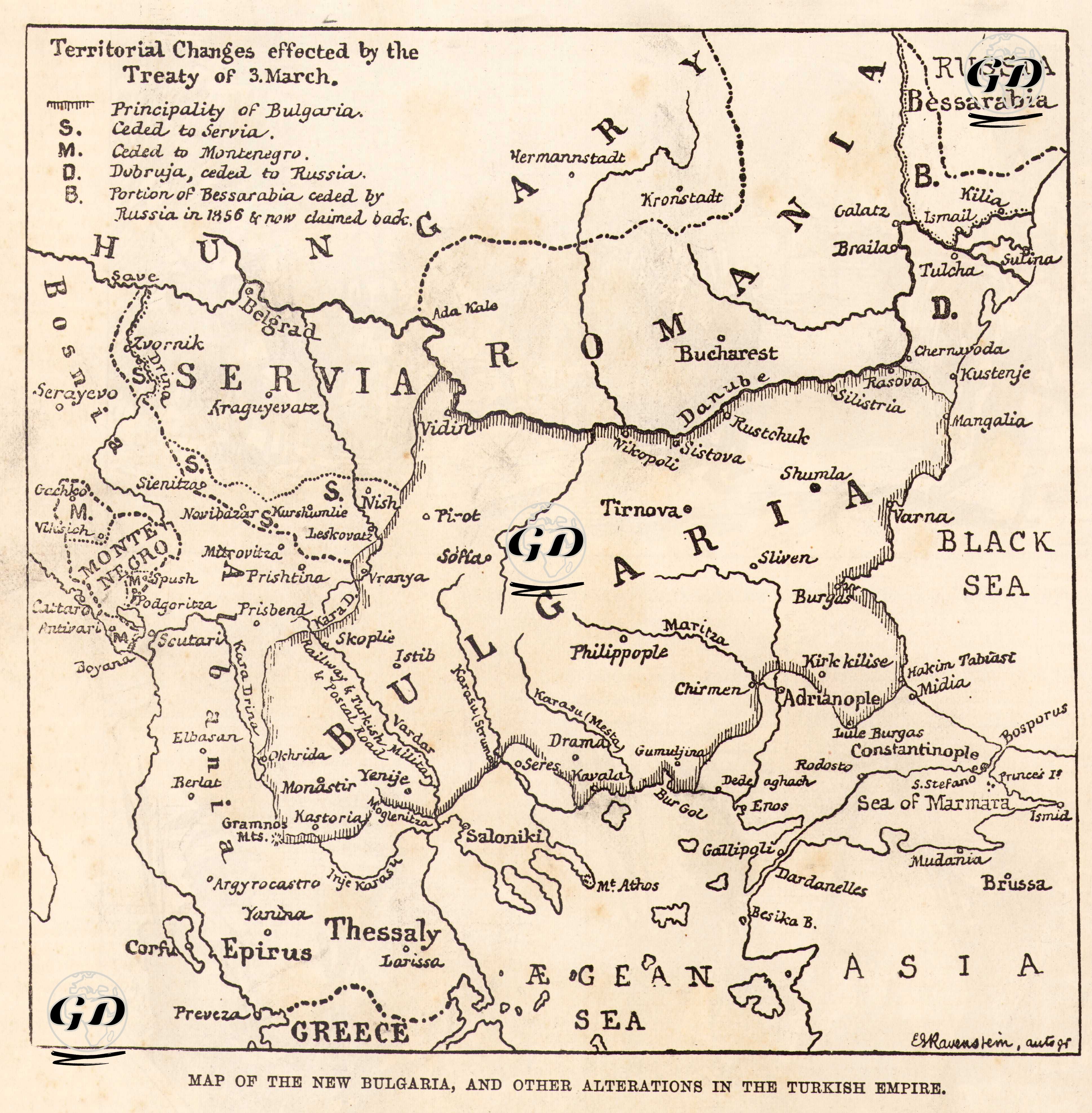
The map and news published in The Illustrated London News on March 16, 1878, detailed the Ottoman Empire’s territorial losses in the Balkans and the new political structures in the region following the Treaty of San Stefano on March 3, 1878 (later to be significantly changed by the Treaty of Berlin). The structure defined as the “New Bulgarian Principality” on the map, established as an autonomous administration under the Ottomans, encompassed a wide geography, not only the areas where the ethnic Bulgarian population lived, but also regions with a majority of Turks, Greeks, Albanians or other elements, such as Macedonia and Eastern Thrace. The symbols indicated in the upper left corner of the map coded the border changes that occurred as a result of the treaty, such as the Principality of Bulgaria, the lands given to Serbia and Montenegro (S and M), the transfer of Dobruja to Russia (D) and the return of a part of Bessarabia to Russia (B). The analysis in the newspaper clearly states that this new structure is a strategic move that disregards ethnic borders and aims to perpetuate Russia’s influence in the region; it is emphasized that this situation could cause serious conflicts and diplomatic crises in the future. As a result of this agreement, the Ottoman lands in Europe shrank to approximately 80,850 square miles, and the population fell to 4,500,000, of which only 2,000,000 were estimated to be Turks. The population structure of the new Bulgaria includes 3 million Bulgarians, 300,000 Turks, 100,000 Jews, 80,000 Greeks, 50,000 Tatars, 30,000 Gypsies, 30,000 Germans, 20,000 Armenians, 10,000 Serbs and 5,000 Italians. Based on this data, the newspaper implies that the San Stefano arrangement is not sustainable and will probably be reviewed at a new international conference to be held in Berlin. The map was drawn by Ernst George Ravenstein (1834-1913), one of the well-known cartographers of the period. When both political and ethnographic evaluations come together, this map and news constitute a very valuable source for understanding the new distribution of power in the Balkan equation that emerged after the Ottoman-Russian War.