GRAVÜR DÜNYASI
Digital Engraving Library
| Date | 1857 |
| Technique | Copper Engraving |
| Category | Maps |
| Source | The History of the War with Russia: Giving Full Details of the Operations of the Allied Armies By Henry Tyrrell (The London Printing And Publishing Company Limited) |
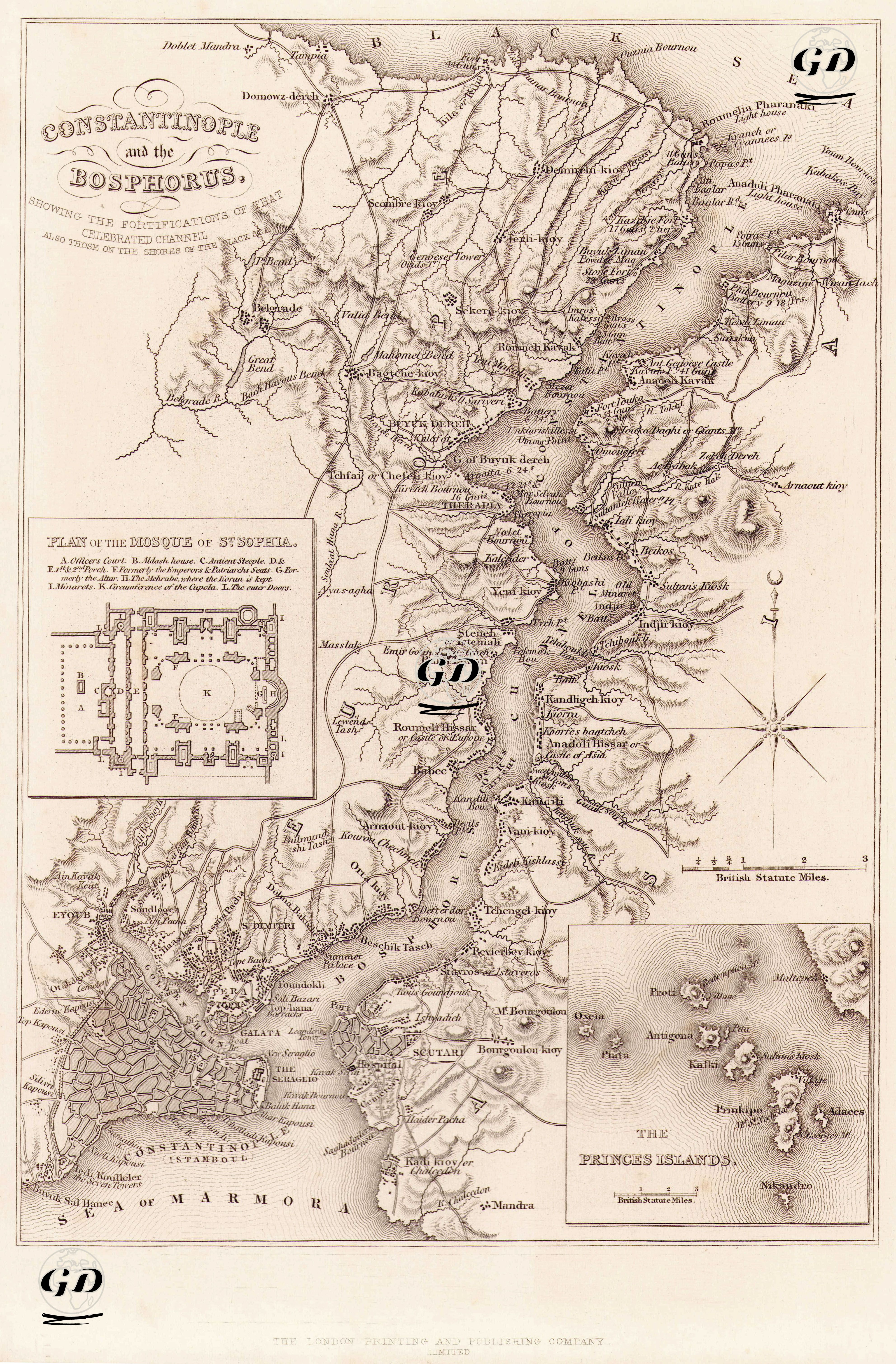
This map, dated 1857, is titled “Constantinople and the Bosphorus” (Istanbul and the Bosphorus) and is both a geographical and military-strategic document. The map particularly shows the fortifications and important positions on both banks of the Bosphorus in detail, while also meticulously depicting the urban fabric and coastal settlements of Istanbul. On the left side of the engraving is the plan of the Hagia Sophia Mosque. In this additional drawing titled “Plan of the Mosque of St. Sophia,” the interior layout, minarets, and entrance structures of Hagia Sophia, which was converted into a mosque during the Ottoman period, are described. In particular, the main space (the domed central section), marked with the letter K, indicates the center of the mosque’s architecture. The map extends from the Rumeli Lighthouse and the Anadolu Lighthouse on the Black Sea coast in the north to the walls of Istanbul on the Marmara Sea coast in the south; Villages, waterside residences, military forts, castles, hilltop names, and roads along this long stretch of the Bosphorus are depicted in detail. On the European side, settlements such as Büyükdere, Tarabya, Yeniköy, Arnavutköy, Ortaköy, and Beşiktaş are clearly visible, while on the Anatolian side, Kandilli, Anadolu Hisarı, Çengelköy, Beylerbeyi, and Üsküdar stand out. The map depicts some military forts positioned along the Bosphorus in considerable detail, reflecting the defensive architecture and military strategy of the period. Artillery positions, in particular, are also numerically indicated. For example, the 11-gun battery at the Rumeli Lighthouse, located at the Black Sea exit at the northernmost tip of the map, and the 21-gun battery at the Anadolu Lighthouse. This demonstrates that the map was prepared not only for topographical purposes but also for geopolitical and military purposes. Another significant element in the lower right corner is the separate cartouche depicting the Princes' Islands. This small map, titled "The Princes' Islands," includes islands such as Büyükada (Prinkipo), Heybeliada (Halki), Burgazada (Antigoni), and Kınalıada (Proti), and their shapes, locations, and sizes are drawn in detail. Known as both a place of exile and a religious retreat during the period, these islands held a significant place in Byzantine and Ottoman history. The city center of Istanbul is depicted in great detail in the lower left corner of the map. Hagia Sophia, Topkapı Palace, the Hippodrome, Galata Tower, city walls, and piers, particularly in the Walled City of Constantinople, are noteworthy. The Galata region and its surroundings are depicted as trade centers where the European Levantine population lived. While no bridges are visible over the Golden Horn, crossing points and transportation networks are hinted at. Furthermore, elevations such as Pera (Beyoğlu) and Taksim are depicted topographically on the map. A compass rose indicates direction, and distances are shown in both British Statute Miles and a proportional scale.