GRAVÜR DÜNYASI
Digital Engraving Library
| Engraver | Ernst George Ravenstein (1834-1913) |
| Date | 1877 |
| Technique | Woodblock Engraving (Newspaper-Text on Reverse) |
| Category | Maps |
| Source | The İllustrated London News (September 29 1877-Page 314) |
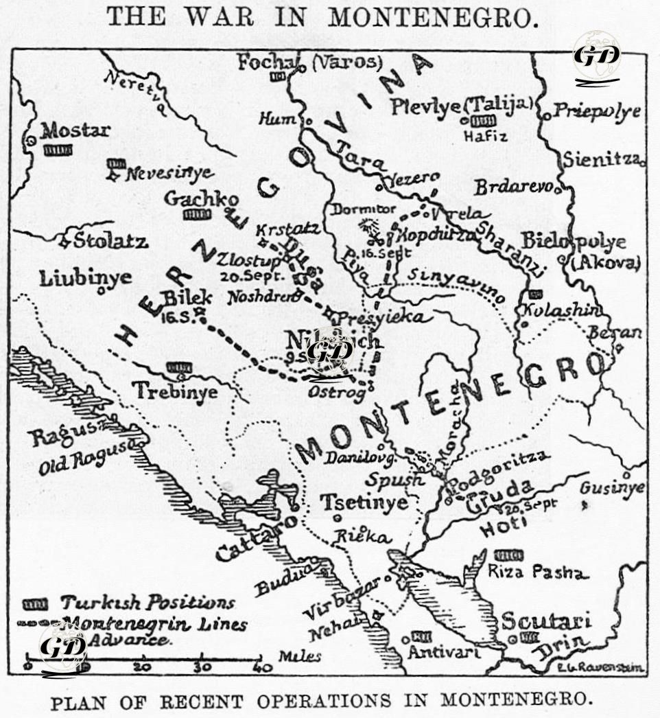
This map, published in The Illustrated London News on September 29, 1877, visually shows the latest developments on the Montenegrin Front and the important stages of the Ottoman-Montenegrin War. The map details the geographical distribution and military movements of the clashes that intensified especially in September 1877 between the Ottoman Empire and the Principality of Montenegro. Nikšić (Nikşic), located in the inner regions of Montenegro and of strategic importance, stands out on the map as the first important center captured by the Montenegrins on September 9. Then, with the fall of the Ottoman fortresses on Bilek and the Duga pass on September 16, there was a serious disintegration of the Ottoman defense lines in the region. The map clearly shows this line; in particular, the direction of the Second Montenegrin Corps advancing north from Bilek and the route of the main corps advancing from the Duga pass towards Gacko, Nevesinje and Mostar are drawn. This movement shows that the Montenegrins aimed to expand into the interior of Herzegovina. In the eastern part of the map, attention is drawn to the battle that took place on September 16 at Kopcica, where the Ottoman forces under the command of Hafiz Pasha were defeated by the Montenegrin forces under the command of Sochi and forced to retreat. The map shows that these forces were driven along the Tara River towards Plevlya (today's Pljevlja) and Kolašin. According to the newspaper report, the Ottoman forces suffered significant losses in this battle, and about a tenth of the 10,000-strong unit was out of action. The map also shows that in the south, the Montenegrin forces under the command of Marko Milanof occupied Gruda on September 20. This development shows that Montenegrin activities on the southeastern border were also intensifying and that it was only a matter of time before they would come face to face with the Ottoman forces under the command of Rıza Pasha. All these military lines are indicated on the map by both Turkish defensive positions (black solid blocks) and the directions of advance of Montenegrin troops (dotted lines), visualizing how the Ottoman defenses in the region came under multi-front pressure.