GRAVÜR DÜNYASI
Digital Engraving Library
| Date | 1750's |
| Technique | Copper Engraving |
| Category | Maps |
| Source | Mr.S.Clark's Family Bible (Printed For & Sold By I.Fuller At Bible in Blonbladder Street Cheapside London ) |
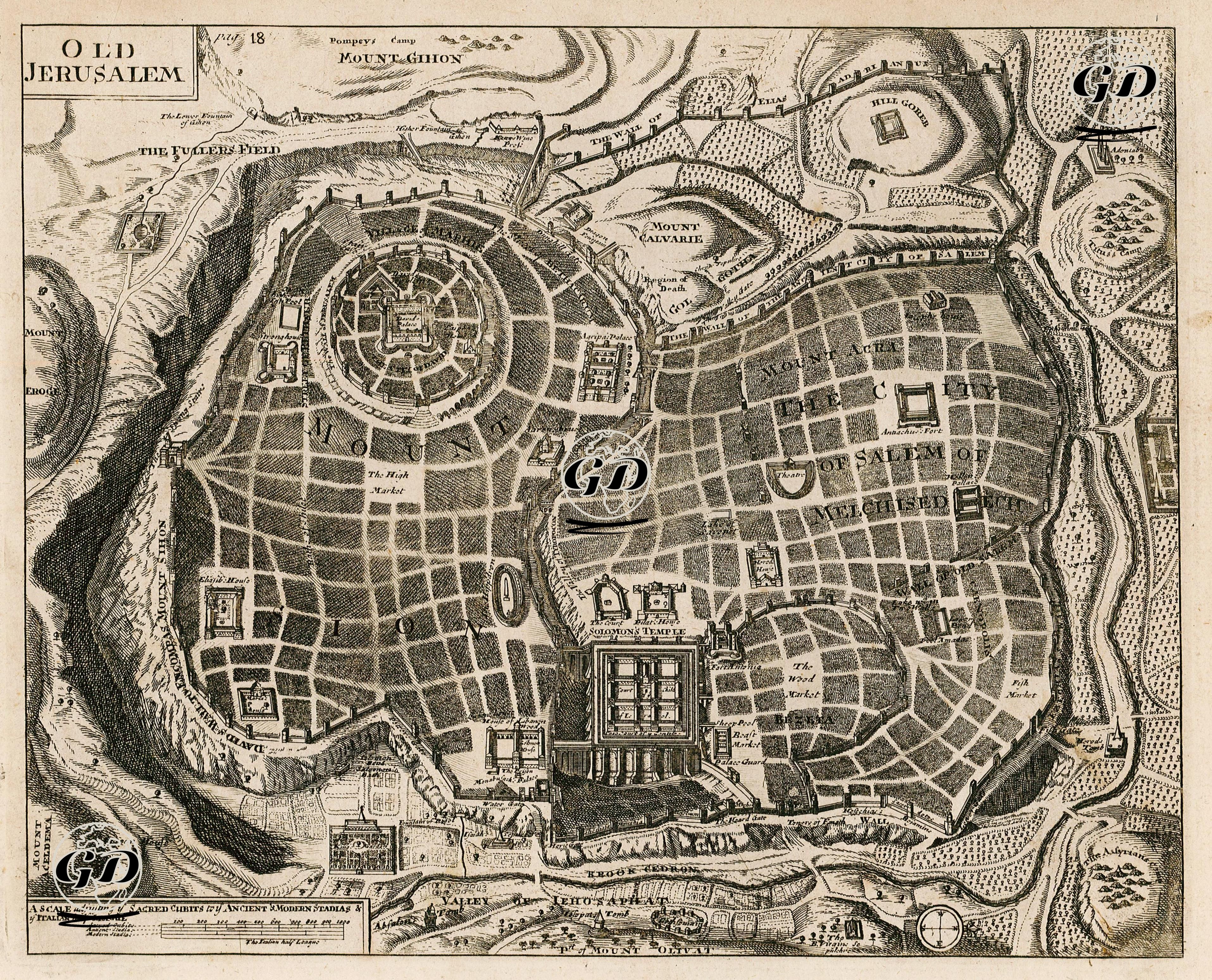
The map titled “Old Jerusalem” prepared in the mid-18th century reconstructs the historical-topographic structure of Jerusalem in the light of sacred texts. The map reflects a theological and symbolic perception of Jerusalem rather than physical geography; the effort to concretize the spatial narratives of the Old Testament and some apocryphal texts on a graphical plane is particularly striking. Jerusalem is here arranged in a circular and radial manner with holiness as its center; Solomon’s Temple, depicted on a monumental scale, is placed right in the center of the city. The temple is drawn in layers such as the Court of the Priests and the Sanctum Sanctorum, divided into ritual sections. This form of presentation expresses the understanding of centrality that is felt strongly in Christian interpretations as well as in the Jewish temple tradition. The urban plan spreading around the temple is surrounded by densely built-up market areas (e.g. the Fish Market), sacred roads, and city wall gates. Areas that play a central role in Christian theology such as Mount Calvary in the north of Jerusalem (the place where Jesus was crucified), the Valley of Kidron in the east, and the Hill of Evil Counsel in the south are also included in detail on the map. In addition, figurative structures such as David’s Palace, Pompey’s Camp, City of Melchizedek and place names with mythological references are also depicted. The expression City of Salem or Melchisedec refers to the earliest periods of Jerusalem and the figure of Melchizedek. In addition, the scale bar at the bottom left of the map presents ancient and modern units of measurement in a comparative manner, which demonstrates the scientific-cartographic understanding of the period. Rather than topographic accuracy, the map has a structure that aims to provide the geographical representation of the Biblical texts and to create the pilgrims’ mental map of Jerusalem. In this respect, the map is not only a historical or cartographic document; It should also be evaluated as a visual representation of theological pedagogy, sacred space memory, and Western geography of faith.