GRAVÜR DÜNYASI
Digital Engraving Library
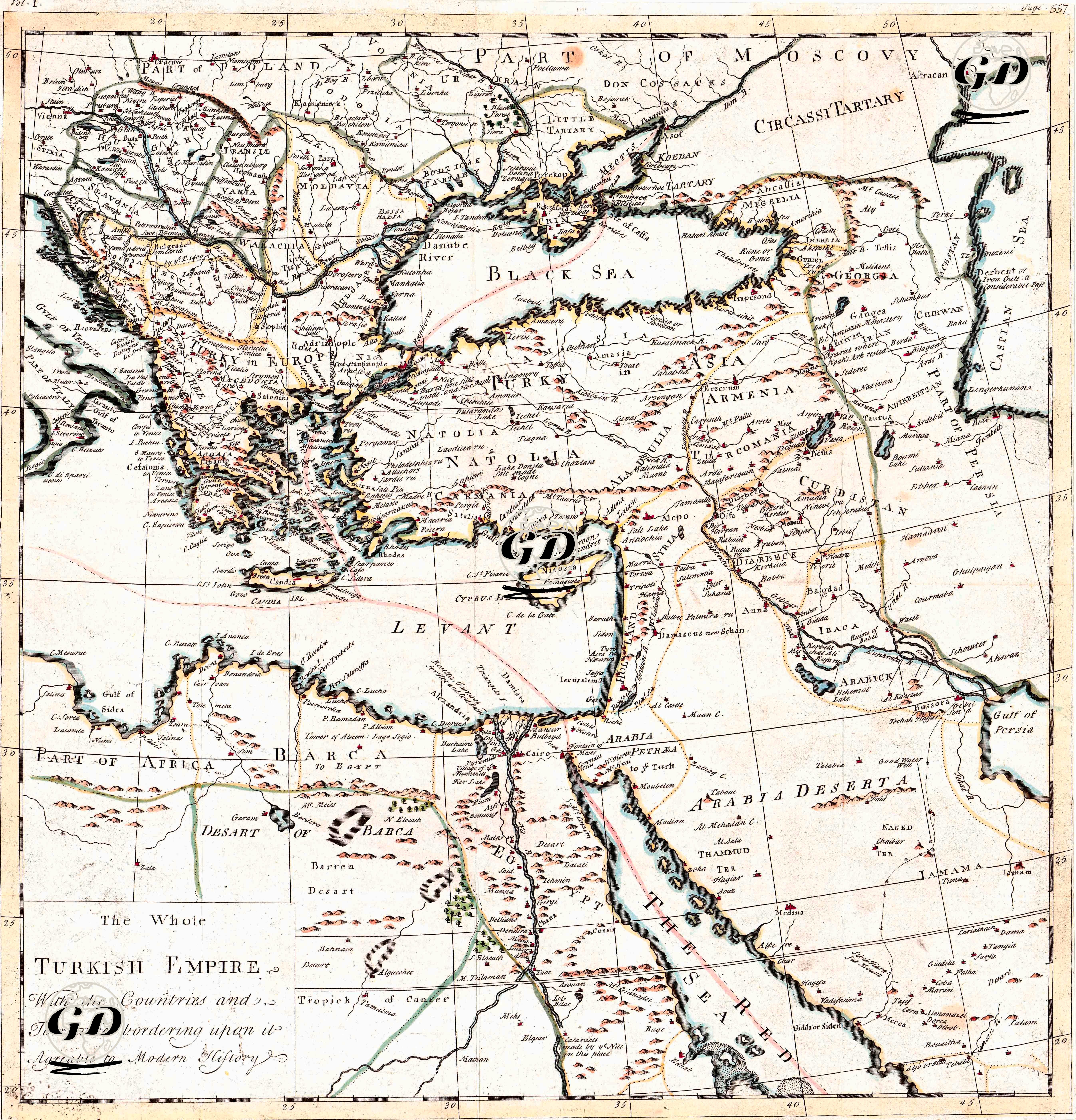
| Artist | Herman Moll (1654-1732) |
| Date | 1725 |
| Technique | Copper Engraving-Original Hand Colored |
| Category | Maps |
This map presents one of the broadest and most comprehensive depictions of the Ottoman Empire's borders at the beginning of the 18th century, encompassing Europe, Anatolia, the Caucasus, the Levant, and North Africa. Published in 1725 by the British cartographer Herman Moll, this 48x45 cm map is of great importance, particularly for visualizing the new political balances that emerged after the Austro-Turkish Wars (1683-1699). The decline of Ottoman dominance in Central Europe following the Treaty of Karlowitz (1699), and the subjugation of Wallachia and Serbia to Austrian influence, are clearly visible on the map. In this respect, the map shows a period in which the Ottoman Empire's borders in the Balkans were redefined. In keeping with Moll's characteristic style, the map brings together political boundaries, provincial names, river systems, and mountain ranges in a balanced manner. Under the title “The Whole Turkish Empire,” the Ottoman geography is named using contemporary Western terminology such as Turkey in Europe, Turkey in Asia, Arabia, Egypt, Barca, Natolia, Armenia, and Circassia. These designations reflect not only a geographical classification but also how the Ottoman world was conceptualized in 18th-century British political and historiographical writing. The prominent emphasis on strategic waterways such as the Black Sea, the Mediterranean, the Red Sea, and the Caspian Sea also points to the central role of the empire's trade and military logistics networks. Herman Moll's map is designed not only as a geographical representation but also as a tool for understanding the balance of imperial power. The careful depiction of the Ottoman borders with Austria, Moscow, Iran, and the Arabian Peninsula reveals that the map aimed to show the Western audience both the "present strength and limitations" of the Ottoman Empire. In this context, the map implies that the Ottoman Empire still ruled over a vast geographical area, but that it had now retreated to a defensive position on the European front.