GRAVÜR DÜNYASI
Digital Engraving Library
| Artist | Augustus Heinrich Petermann (1822-1878) |
| Engraver | John James Dower (1825-1901) |
| Date | 1850 |
| Technique | Copper Engraving-Original Hand Colored |
| Category | Maps |
| Source | A Descriptive Atlas of Astronomy, and of Physical and Political Geography by Thomas Milner - London, Published By Orr And Comp. Amen Corner Paternoster Row |
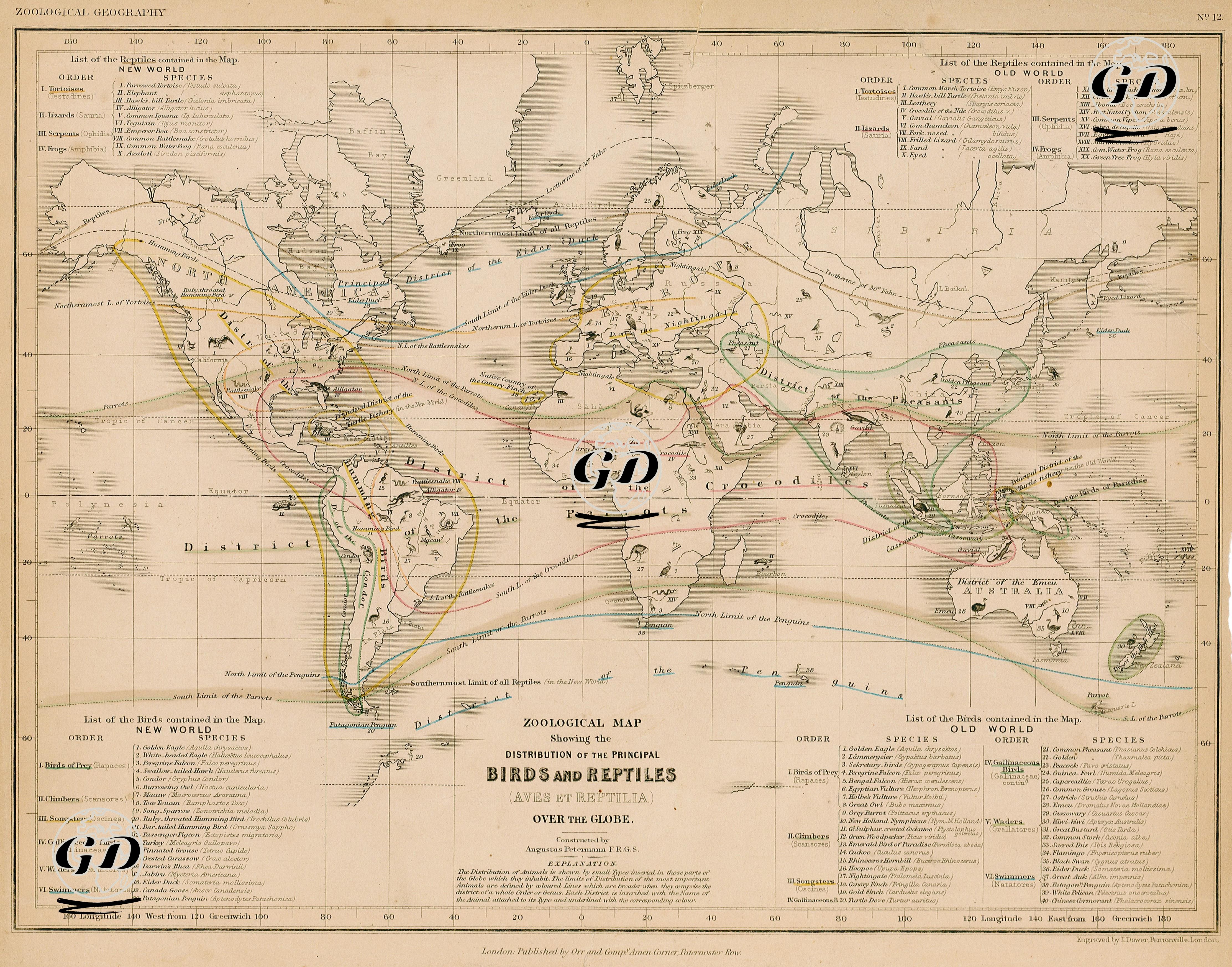
The map, titled “Zoological Map of the Distribution of the Principal Birds and Reptiles of the World” and dated 1850, visualizes the geographical distribution of birds (Aves) and reptiles (Reptilia) on earth in a scientific order. Prepared by Augustus Petermann, a German cartographer and member of the "Royal Geographical Society", this map expresses the global distribution of species with both symbols and linear boundaries, while marking the regions where certain living groups lived with animal icons and colored contour lines. The map is divided into two main regions: New World and Old World. Separate bird and reptile classes are listed for each region. For example, among the bird species in the New World are species such as vultur gryphus (Andean condor), trogon mexicanus, colibri (hummingbird), aras (parrots), and tinamous (land birds native to South America); Among the reptiles there are boa constrictors (boa constrictors), iguanas, alligators (crocodiles) and testudines (turtles). In the Old World list, bird species such as struthio camelus (ostrich), psittacus erythacus (African grey parrot), hornbill (hornbills), cygnus olor (swan), pelican (pelican) and reptiles such as varanus, crocodilus vulgaris, cobra di capello, chelonia and python reticulatus are detailed. In addition, biogeographic regions specific to birds such as “District of the Parrot”, “District of the Ostrich”, “District of the Humming Bird” are defined on the map. These definitions show not only the physical locations of the species but also how they are shaped by climatic and environmental boundaries. The map constitutes an example of early ecological cartography by including environmental conditions affecting the distribution of living things along with geographical elements such as tropics, tropics, equator line and ocean currents. The map not only catalogued the distribution of species, but also attempted to visually present their natural boundaries, lifestyles, and regional adaptations. Petermann's work thus integrated not only zoological but also geographical thought with natural history.