GRAVÜR DÜNYASI
Digital Engraving Library
| Artist | Thomas Gamaliel Bradford (1802-1887) |
| Engraver | Robert Scott (1777-1841) |
| Date | 1835 |
| Technique | Steel Engraving |
| Category | Maps |
| Source | Atlas of Universal Geography by Thomas Gamaliel Bradford - Published By Arch. Fullarton & Co. Glasgow |
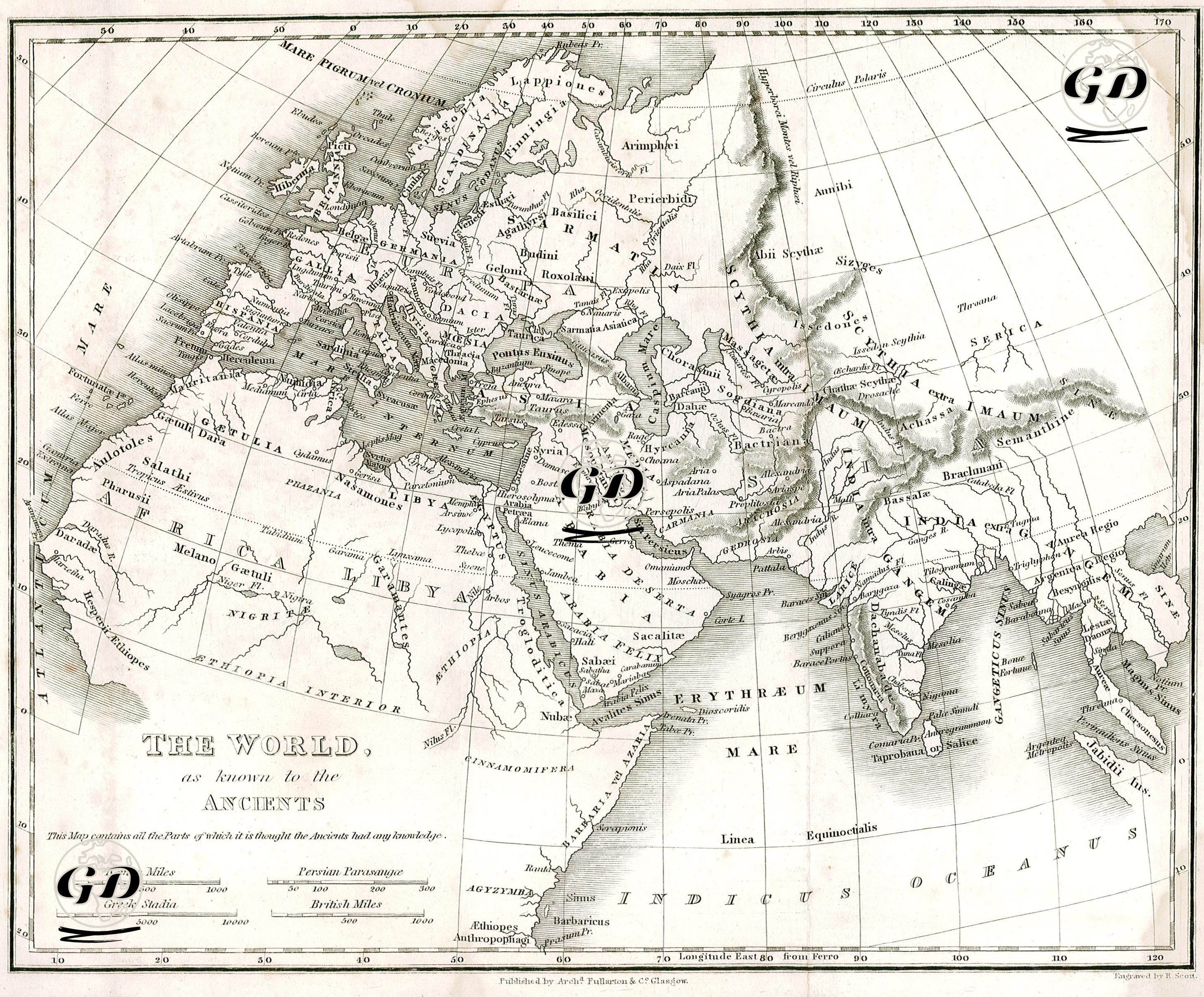
This map is titled “The World as Known by Ancient Civilizations” and represents the geographical knowledge of the ancient period (especially known in the Greco-Roman world). Published in 1835, this map is a valuable cultural document prepared to define the borders of the ancient world and to show the geographical boundaries of the intellectual universe of that period. This map was prepared based on the knowledge of the ancient Greeks and Romans about the world and reflects the geographical perception of the period from the 1st century BC to the 2nd century AD. The map includes the known lands within the borders of the Roman Empire, the regions reached by Hellenistic discoveries and the geographical names mentioned in ancient texts. The central reference point is the Mediterranean Basin; this shows that the map has a Rome-centered perception of the universe. The Mediterranean, defined as “Mare Internum”, is located in the very center of the map and the surrounding lands are the center of the ancient world order. Anatolia was shown as “Asia Minor” on the map and divided into ancient regions such as Troas, Lydia, Phrygia, Pamphylia, and Cilicia. Similarly, the region of Greece (Graecia) was detailed with classical regions such as Epirus, Thessalia, and Attica. Italy (Italia) was separated with ancient terminology such as Campania and Latium, and the geographical center of Rome was emphasized. Mesopotamia was detailed as “Assyria,” “Babylonia,” and “Mesopotamia” on the map and was defined as the rich geography between the Euphrates and Tigris rivers. These areas were regions that held an important place in the information sources of the ancient world. The area of the Persian Empire was indicated with ancient province names such as “Persis,” “Media,” and “Bactriana.” The African continent was named "Libya" and "Aethiopia" (Ethiopia) in the north, but its interior was referred to by more vague and speculative ethnic names such as "Nigritis" and "Melano-Gaetuli". This shows that the ancients had limited knowledge of sub-Saharan Africa. India is divided on the map into "India intra Gangem" (India within the Ganges River) and "India extra Gangem" (India beyond the Ganges River). The information obtained about India, especially after the campaigns of Alexander the Great, in ancient Greek sources made it possible to map this region. The positioning of the Ganges River and some coastal cities is remarkable. The map also includes regions based on the narratives of ancient travelers and historians: it was shaped by information received from ancient geographers such as Strabon, Herodotus, and Ptolemy. The extremities of East Asia (for example, "Serica" corresponds to China) constitute both an informational border and a representation of the exotic and inaccessible. Most of the geographical areas are indicated by ancient people names (for example, Scythians, Sarmatians, Celtic Tribes, Arabes, Phoenices, Armenii), and instead of the modern concept of nation and state, a tribal or cultural geography approach is adopted.