GRAVÜR DÜNYASI
Digital Engraving Library
| Artist | John Rapkin(1815-1876) |
| Engraver | John Rapkin (1815-1876) |
| Date | 1860 |
| Technique | Steel Engraving |
| Category | Maps |
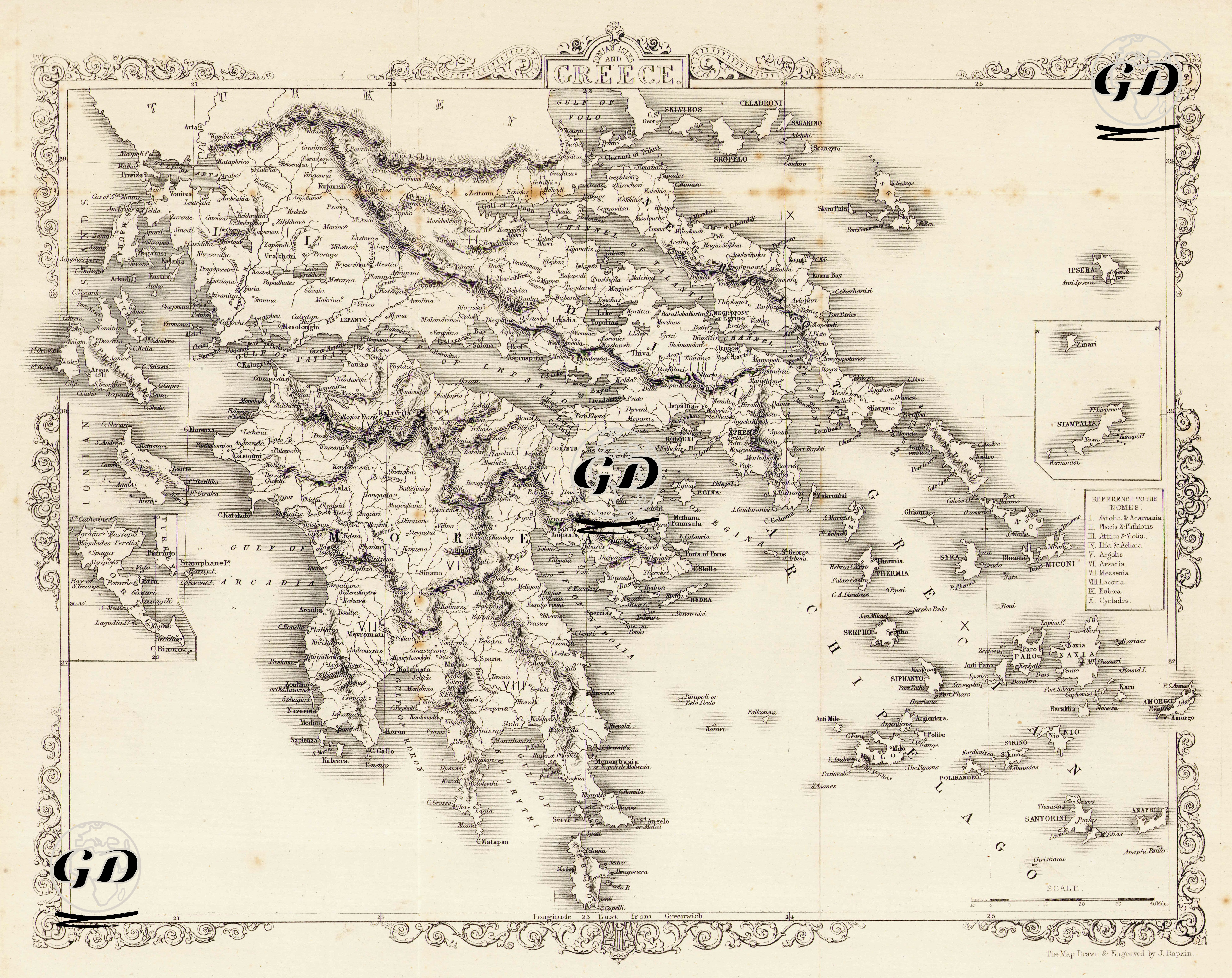
This 1860 map depicts the geographic, administrative, and cultural structures of Greece in detail. The map encompasses not only the modern-day Greek mainland but also the vast group of islands scattered across the Aegean Sea. The border decorations make the map an aesthetic work of art and reflect the use of figurative frames common in period cartography. A legend titled "REFERENCE TO THE DIVISIONS" appears in the lower right corner of the map. This legend indicates ten separate divisions, each numbered according to ancient or administrative regions: I. Thessaly, II. Epirus, III. Macedonia, IV. Attica & Euboea, V. Aetolia & Acarnania, VI. Locris, Doris & Phocis, VII. Peloponnesus, VIII. The Isles, IX. Crete, and X. The Cyclades. This classification, distributed across the map in accordance with the place names on the map, aims to establish a connection between the ancient regions of the classical period and the 19th-century descriptions. Important cities on the map include Athinai (Athens), Corinth (Korinth), Patras, Sparta (Sparti), Larissa, Thessaloniki, Thebes, and Argos, centers of great importance since ancient times. Similarly, the islands section identifies notable centers of both classical mythology and historical trade and maritime power, such as Santorini, Naxos, Syra, Paros, Tinos, Delos, Samos, and Rhodes. Furthermore, the region encompassing Boeotia-Phocis in Central Greece is designated as LIVADIA, and the Peloponnesian Peninsula as MOREA. The map presents a detailed settlement network for both the mainland and the islands, meticulously depicting port cities, mountainous regions, and coastlines. Corfu (or Kerkira) is specifically designated in a small cartouche in the lower left corner, while Tinos and Stampalia are detailed in the upper right. Sea names are also given using classical terminology. The Aegean Sea is defined as the "Archipelago," while regional sea and gulf designations such as the "Gulf of Corinth," "Myrtoan Sea," and "Gulf of Nauplia" are also included. The typography used throughout the map is also quite clear, written in antique-colonial serif letters. Shading representing elevations adds depth to the coastlines and facilitates the topographical interpretation of mountainous features. The map also includes the northern regions where the Ottoman Empire was still influential, and this area is defined as "TURKEY".