GRAVÜR DÜNYASI
Digital Engraving Library
| Date | 1820's |
| Technique | Copper Engraving |
| Category | Maps |
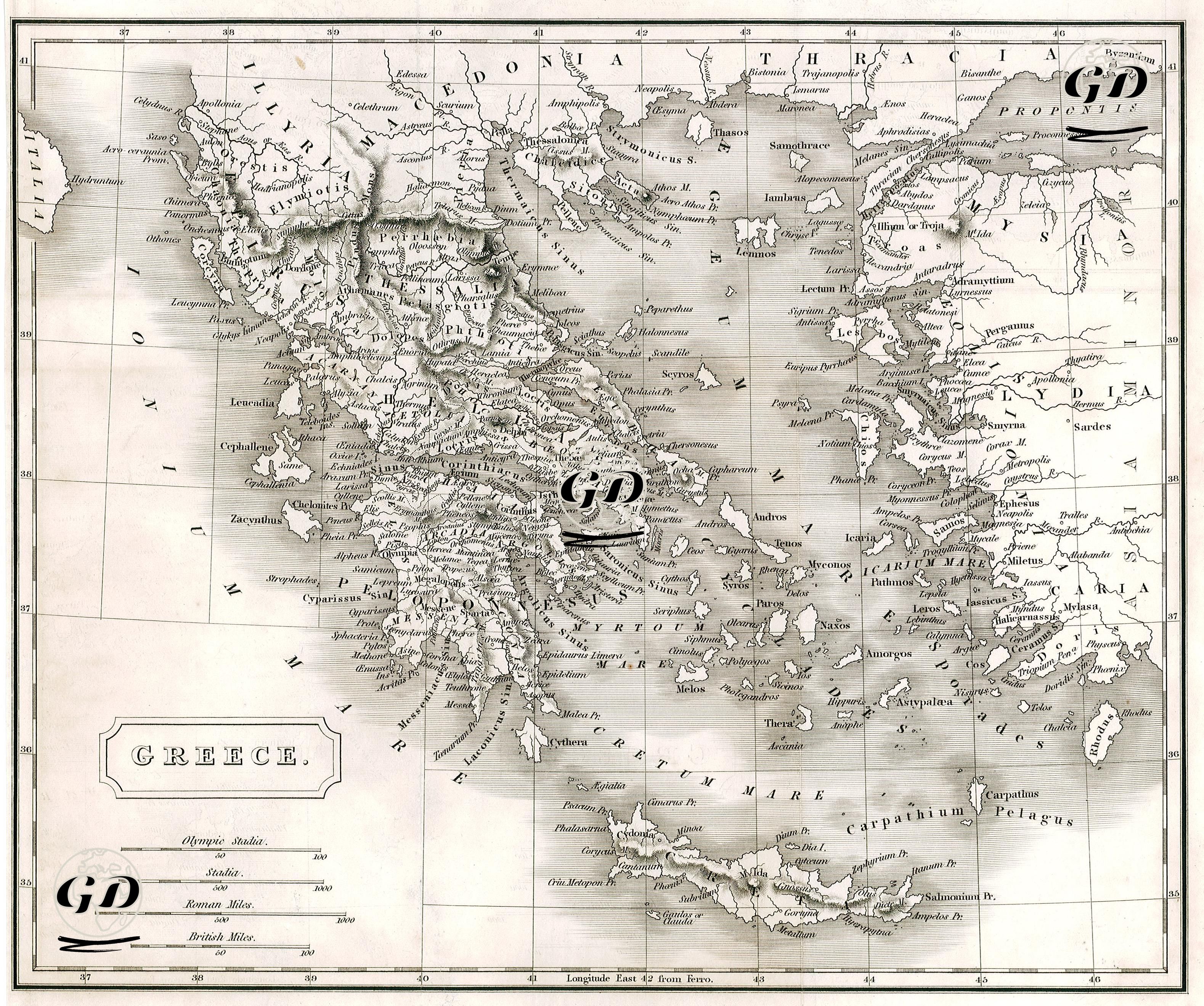
This map comprehensively represents the mainland territories of the ancient Greek world and the islands scattered across the Aegean Sea. The map's scope extends not only to modern-day Greece but also includes the western coast of Anatolia, the regions of Illyricum (Illyria), Macedonia, and Thrace to the north, and the ancient regions of Asia Minor, such as Lydia, Caria, Mysia, and Ionia, to the east. The toponyms on the map are given in their classical form; ancient cities such as Sparta, Athens, Corinthus, Delphi, Thermopylae, Ephesus, Sardis, and Rhodes are clearly depicted. Structurally, the map exhibits a highly refined cartographic craftsmanship. The rendering of the seas with shaded, parallel lines, the fine delineation of the coastlines, and the inland mountainous regions, which are rendered in relief, are all indicators of the techniques frequently used in engraving cartography of the period. The Aegean Sea is called “ÆGAEUM MARE”, the Mediterranean Sea “MEDITERRANEAN SEA”, the Cretan Sea “CRETICUM MARE” and the Carpathian Sea “CARPATHIUM PELAGUS”. This terminology is presented both based on ancient sources and in accordance with the traditions of classical cartography. Four different distance systems are shown in the lower left corner of the map as units of measurement: the Olympic Stadia, the Stadia, the Roman Mile, and the British Mile. This multiple measurement system connects the map's ancient texts with modern geography. Among the ancient cities along the coast of Asia Minor, important centers such as Ephesus, Smyrna, Sardis, Magnesia, Halicarnassus, and Miletus are highlighted as part of a cultural and trade chain extending across the Aegean basin. Most of the Aegean islands are also included on this map and identified with their significant mythological or historical contexts. Islands such as Delos, Naxos, Paros, Lesbos, Chios, and Samos were important centers for both the cult of Apollo and trade routes. Thrace (THRACIA), located in the north, held strategic importance during the Roman and Hellenistic periods. Byzantium (later Constantinople/Istanbul) is located in the northeast corner of the map and is shown together with the Propontis (Sea of Marmara).