GRAVÜR DÜNYASI
Digital Engraving Library
| Date | 1830's |
| Technique | Copper Engraving |
| Category | Maps |
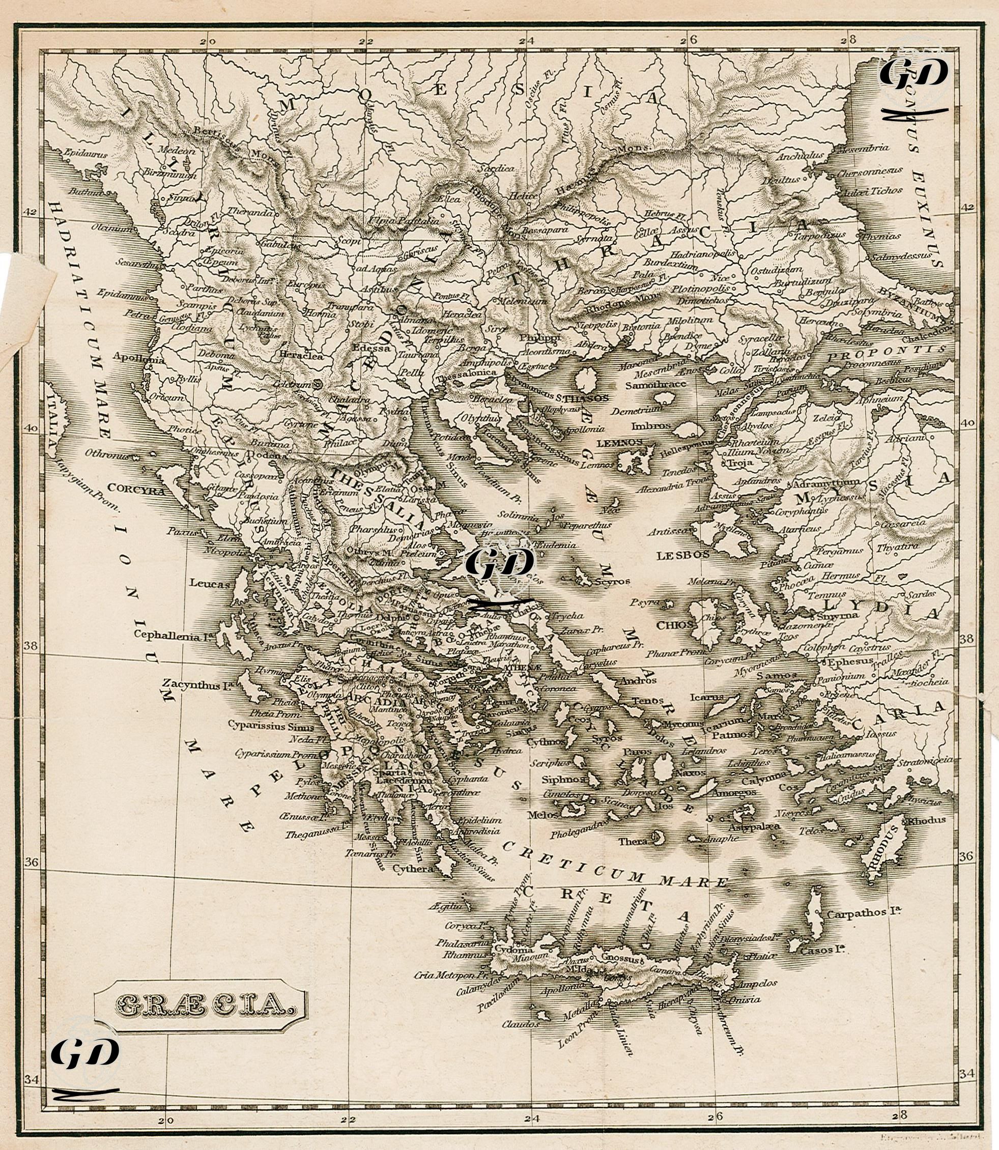
Under the heading "Græcia," this map depicts the geography of ancient Greece in detail, encompassing not only modern-day Greece but also the western Anatolian coast, the Aegean Islands, Thrace, Macedonia, and parts of the Balkans. The map's graphical language conforms to the classical cartographic tradition of the early 19th century, presenting the regional geography using ancient terminology. Place names are written in Latin or Hellenistic form: for example, "Creta," "Chios," "Lesbos," "Aetolia," "Thessalia," "Macedonia," "Bithynia," and "Troas." The map extends from the Adriatic Sea (Mare Adriaticum) eastward to the Propontis (Sea of Marmara) and Pontus Euxinus (Black Sea), and southward to the Creticum Mare (Sea of Crete) and the northern coast of Cyprus. The Peloponnesian Peninsula depicts the lands of classical Greek city-states such as Laconia, Messenia, Argolis, and Arcadia. In the center, Hellenic regions such as Boeotia, Attica (around Athens), Phocis, and Doris are carefully depicted, as are the Hellenistic or Hellenistic-influenced kingdoms of Thessalia, Epirus, Illyricum, and Macedonia in the north. Thrace is presented as a key connection between Europe and Asia, with Byzantium (the ancient name of Istanbul) featured in detail in the northeast of the map. Looking east, coastal cities of ancient Ionia, Aeolia, Caria, and Lycia (e.g., Smyrna, Ephesus, and Miletus) are depicted along the coast of Asia Minor. The Aegean Islands are particularly prominent on the map: Lesbos, Chios, Samos, Naxos, Delos, Rhodes, and many other islands are given their ancient names. A striking feature of the map is the shading technique used to depict mountain ranges and rivers, enriching the map both aesthetically and geographically. The title "Græcia" appears in the lower left corner of the map with a Gothic border, while degree markers and length lines are carefully placed along all edges. The font is ancient, emphasizing its cartographic elegance. The map is not just a representation of ancient geography, but also a document that revisits the cultural and political heritage of the Hellenistic world. Along with geographical references, ancient cities, coastlines, ports, and trade routes are depicted with contemporary knowledge. Bu yönüyle harita, Antik Yunan’ın şehir-devlet düzeni, bölgesel farklılıkları ve denizcilik kültürünü anlamak açısından değerli bir kaynaktır.