GRAVÜR DÜNYASI
Digital Engraving Library
| Engraver | Albert Henry Payne (1812-1902) |
| Date | 1870's |
| Technique | Steel Engraving |
| Category | Maps |
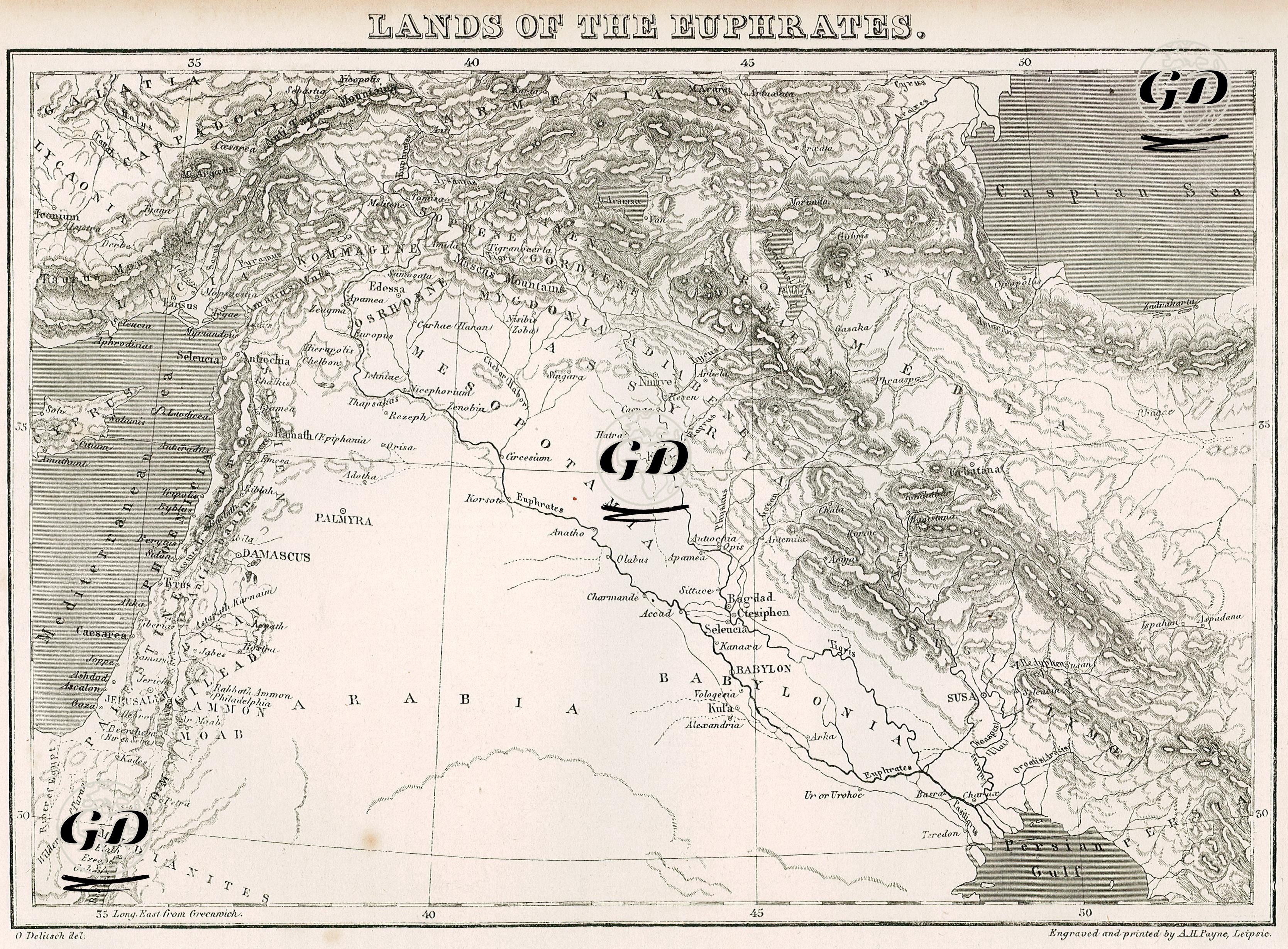
Titled “Lands of the Euphrates”, this historical map is a cartographic engraving that presents the geography of Mesopotamia from an ancient perspective, detailing the areas where the Sumerian, Babylonian, Assyrian and Persian civilizations developed. The map covers a wide area from the Anatolian plateau in the north to the Persian Gulf in the south, while also covering the area from the Levantine coast in the west to the Caspian Sea in the east. Engraved and printed by Albert Henry Payne, this work presents ancient roads, settlements and natural geographical elements, showing the Euphrates and Tigris river systems in detail. Important ancient cities such as Ur, Erech (Uruk), Babylon, Ctesiphon, Nineveh and Seleucia on the map indicate the rich historical heritage of Mesopotamia, while Persian centers in the east such as Susa, Persepolis and Ecbatana reveal the expansion and sphere of influence of the Persian Empire. Likewise, cities such as Jerusalem, Damascus, Palmyra and Antioch located in the west of the map are important for both the Roman, Byzantine and Islamic worlds. Topographically, mountain ranges, river branches and plateaus are meticulously depicted; the Zagros Mountains, Taurus (Toros) and Liban Mountains are depicted with distinct reliefs. Ancient regional names such as “Babylonia”, “Assyria”, “Armenia”, “Media”, “Syria” and “Arabia” are used on the map to emphasize the historical and cultural geography long before modern national borders. In addition, the map shows in detail the basins of the Euphrates (Euphrates) and Tigris (Tigris) rivers, the two main water sources of Mesopotamia. The settlement areas, trade routes and mountain ranges that developed along these rivers are carefully depicted on the map. The title “Lands of the Euphrates” at the top of the map emphasizes that this geography has not only physical but also historical, cultural and theological value; since this region is also defined as the “cradle of civilization”. The map was prepared based on classical texts and ancient sources and is one of the reference sources for both ancient history research and geographical evolution.