GRAVÜR DÜNYASI
Digital Engraving Library
| Engraver | William Johnston (1802-1888) - Alexander Keith Johnston (1804-1871) |
| Date | 1856 |
| Technique | Lithography-Colored |
| Category | Maps |
| Source | Pictorial History Of The Russian War 1854-5-6 - W.R.Chambers London & Edinburgh -Printed in Colours by Schenck & McFarlane, Edinburgh |
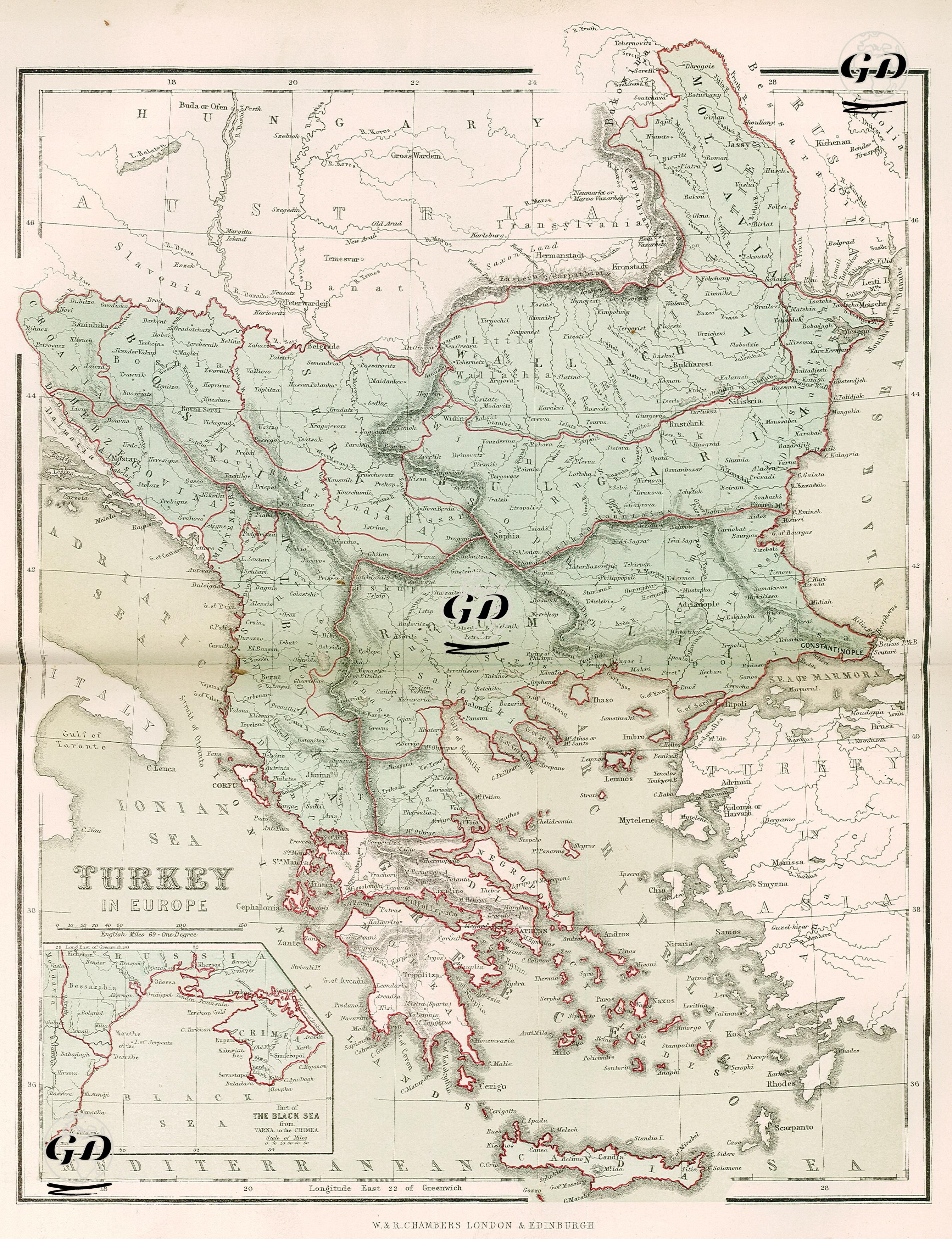
This map, dated 1856 and published in the source titled “Pictorial History of the Russian War 1854–5–6”, shows the Ottoman Empire’s lands in Europe (Rumelia) and the surrounding strategic regions in detail. The map was prepared specifically in the context of the Crimean War and is a visual source that highlights the Ottoman-Russian-Austrian borders and aims to better understand the geography where the war took place. The name of the map is “Turkey in Europe”, which refers to the situation of the Rumelia region and the Balkans under Ottoman rule at that time. The map shows a wide geography starting from the Hungarian and Austrian borders in the north, extending as far as the Black Sea coast in the east, and the Adriatic and Ionian seas in the west. Regions such as Wallachia (Wallachia), Moldavia, Bulgaria, Serbia, Bosnia, Albania, Macedonia and Thessaly, which were provinces of the Ottoman Empire, are marked in detail; these are surrounded by red lines to make their borders clear. Istanbul (Constantinople) is particularly emphasized; It is located in the upper right corner of the map and the strategic location of the Bosphorus is clearly visible. In the lower left corner of the map, a small map shows the western part of the Black Sea and the Crimean peninsula and its surroundings. These details are intended to highlight strategic areas for the war's naval and land operations. The map also allows distinguishing between the regions of Greece that have gained independence and those still under Ottoman rule. Topographic details are given by shading, and rivers, mountain ranges and important passes are clearly marked. As a result, this map is a document that not only shows the scene of the Crimean War, but also depicts the political and military position of the Ottoman Empire in Europe in the mid-19th century.