GRAVÜR DÜNYASI
Digital Engraving Library
| Artist | Ernst Georg Ravenstein (1834-1913) |
| Date | 1877 |
| Technique | Woodblock Engraving (Newspaper-Text on Reverse) |
| Category | Maps |
| Source | The Illustrated London News (June 16 1877- Page 573) |
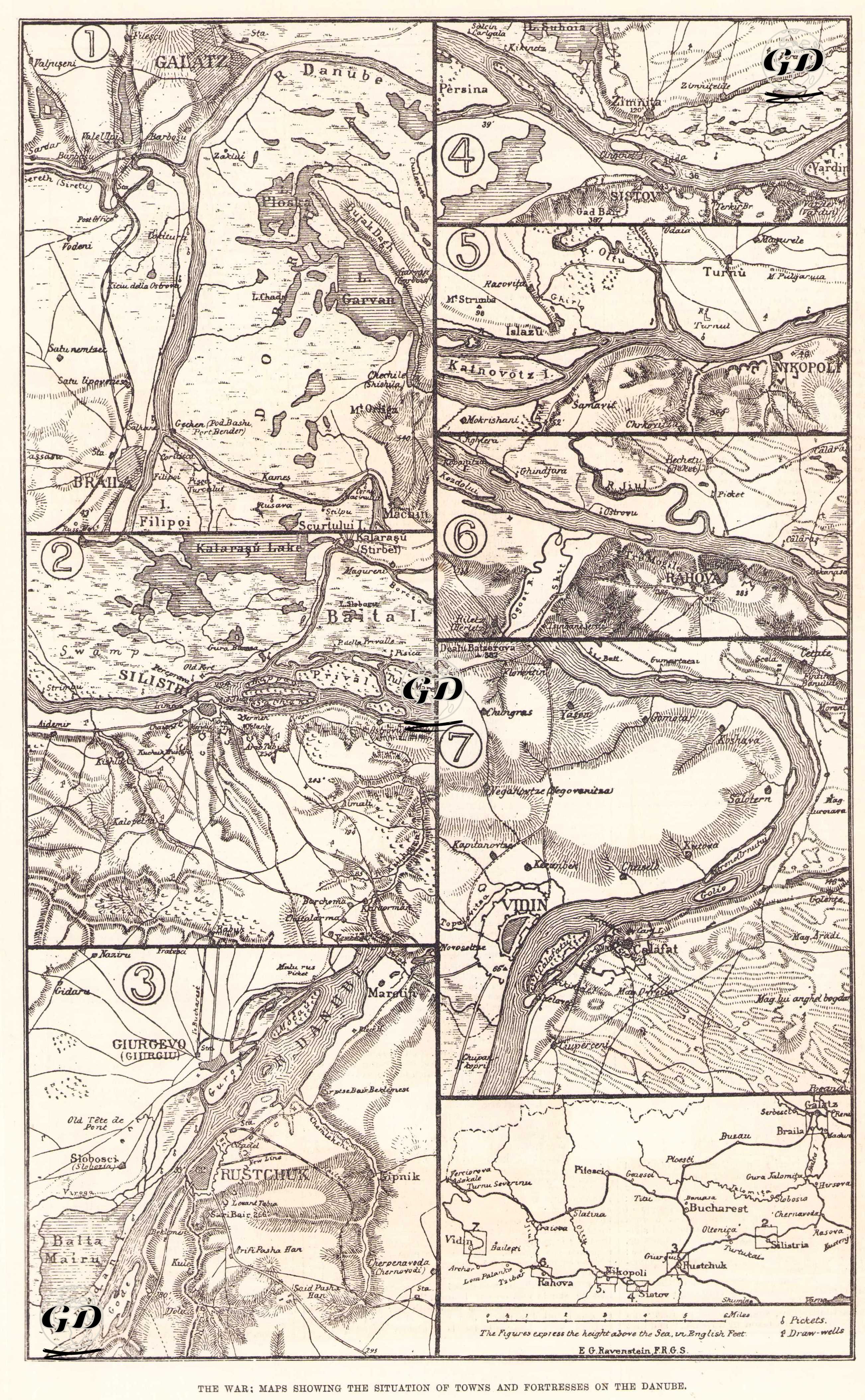
This multi-panel map, published in The Illustrated London News on 16 June 1877, depicts in detail the situation of the principal cities, fortresses, crossing points, and strategic positions along the Danube River during the Russo-Turkish War of 1877-1878. Prepared by Ernst Georg Ravenstein, a member of the Royal Geographical Society, the map was drawn in the early stages of the war to inform the international public. The map is divided into eight main panels. The multi-panel structure dissects the long course of the Danube River, depicting in detail areas to which both the Ottoman and Russian armies attributed critical importance throughout the war. The map in the bottom right shows a bird's-eye view of the Danube River from the locations described in the other panels. Each additional panel shows a different section of the Danube River: Panel 1 (Galați (Galatz) and Brăila Region); This panel covers Galați, one of the Russian army's closest staging areas to the Danube, and Brăila, an important Ottoman trade and defense center. The channels opening into the delta system and the swampy lands are depicted as natural obstacles that limited the mobility of the armies. Panel 2 (Silistra); Silistra, one of the Ottoman Empire's strongest fortifications along the Danube, is shown in detail with its defensive lines, forts, ammunition depots, and coastal artillery. Because Silistra was among the strategic targets of both the Russians and the Ottomans, it is depicted with great care on the map. Panel 3 (Ruse (Rutschuk) and Giurgiu); This panel shows the passage between two important garrisons, Rusçuk (Ottoman) and Giurgiu (under Romanian/Ottoman influence). Rusçuk's strong fortifications, river crossings, and ship traffic are detailed in this section. It is of particular importance as it is one of the narrowest and most passable points of the Danube. Panel 4 (Ismail and its Surroundings); At this point, where Russia descends to the Danube via Bessarabia, Ismail plays a critical role in river crossings, logistics lines, and defensive alignments. The panel provides insights into the potential directions of the Russian offensive. Panel 5 (Turnu - Nicopolis Line); This section shows Turnu, located in an area dominated by the Danube's wide meanders, and the surrounding area of Nicopolis, a key Ottoman fortress city. Nicopolis' strategic location along the river is particularly emphasized. Panel 6 (Rahova (Orjahovo)); Ottoman fortifications, coastal forts, and river crossings are depicted in this panel. Rahova gained importance as a route of retreat for the Ottoman army later in the war. Panel 7 (Vidin Region); The final panel shows Vidin and its surroundings, one of the strongest Ottoman fortresses on the Danube. Vidin's extensive fortification system, forts, logistics routes, and river traffic are shown on the map with detailed topography. The Vidin line was one of the crossing points through which Ottoman resistance retreated into the Balkans. Therefore, this map shows not only topographically but also the geographical logic of the war, strategic decision points, and how the natural structure of the Danube shaped military mobility.