GRAVÜR DÜNYASI
Digital Engraving Library
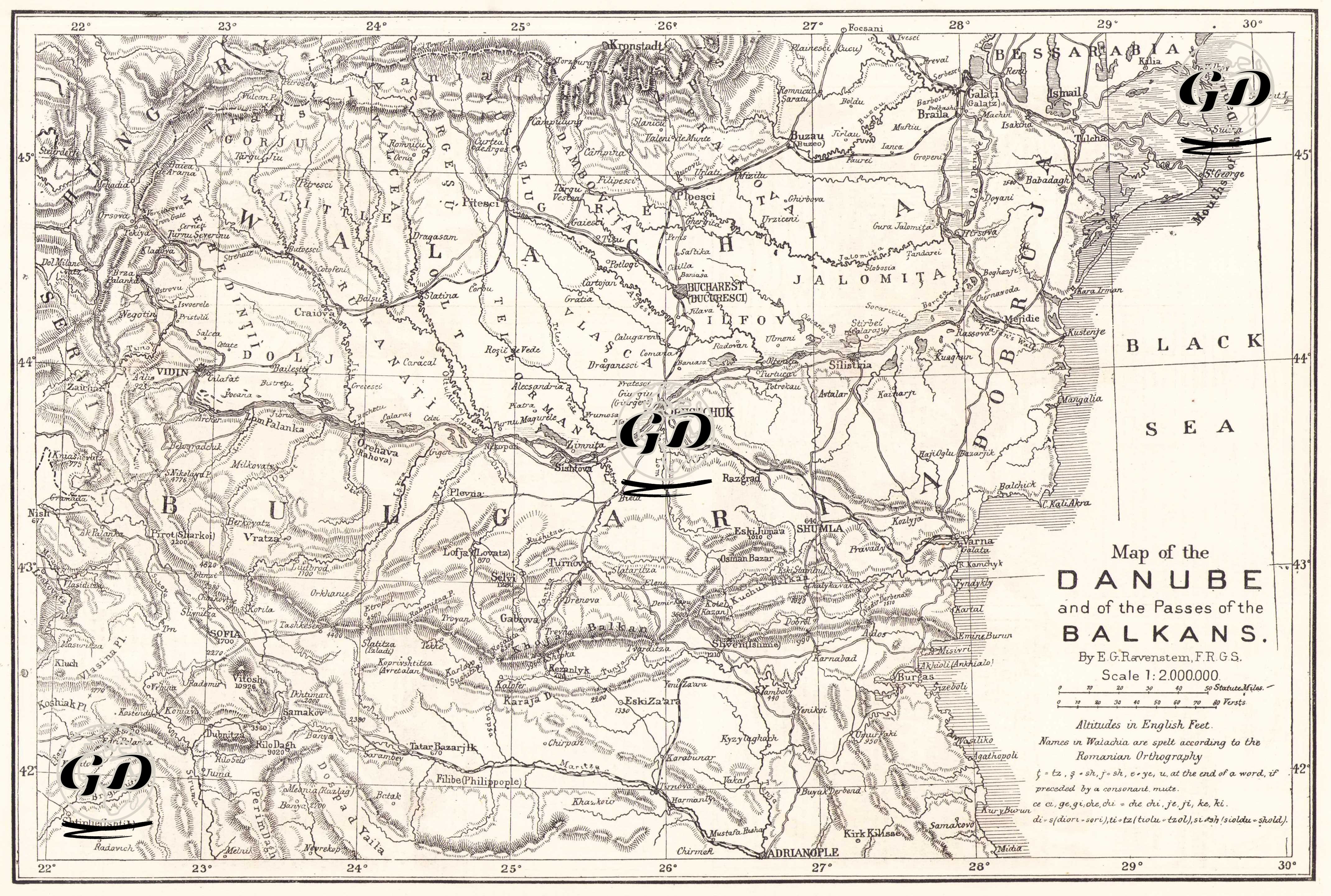
| Artist | Ernst Georg Ravenstein (1834-1913) |
| Date | 1877 |
| Technique | Woodblock Engraving (Newspaper-Text on Reverse) |
| Category | Maps |
| Source | The Illustrated London News (May 19 1877- Page 477) |
This detailed engraved map, published in the May 19, 1877, issue of The Illustrated London News, depicts the most critical geographic area defining the European front of the 1877-78 Russo-Turkish War, focusing on the lower Danube basin and the main passes of the Balkan Mountains. Prepared by cartographer Ernst Georg Ravenstein, the map was used by contemporary war analysts as a fundamental resource for understanding the likely lines of operations of the Ottoman and Russian armies. The map depicts in detail the Lower Danube region, starting from the Hungarian and Serbian borders and encompassing Ottoman and Romanian cities such as Tulcea, Isakci, Machin, Braila, and Galatz. The Danube was Eastern Europe's largest logistical artery in the 19th century, and the fortresses along the river (especially Ruse, Silistra, and Vidin) formed the backbone of the Ottoman Balkan defenses. The Russian army's attempts to cross the Danube were concentrated on these points marked on the map, and the threats to Dobruja increased the military importance of the region. The map clearly shows the Balkan Mountain Range extending westward from Cape Emine on the Black Sea coast. This mountain range served as a natural defensive line for the Ottomans. As Prussian General Helmuth von Moltke noted, the real difficulty in crossing the Balkans stemmed not from the height of the mountains, but from the narrowness and poor maintenance of the roads, and the complete impassability of many passes to wheeled vehicles. The main passes shown on the map are: 1. Karnabat - Bosphorus Pass, 2. Pravadi - Aydos line (Chenga Pass), 3. Varna - Burgas coastal road, 4. Tarnovo - Kasanlik - Shipka Pass, 5. Tarnovo - Slivno - Demir Kapi, 6. Osman Pazarı (Omurtag) - Karnabat road, and 7. Lovech - Tatar Pazarcık line. These passes were the only possible routes for Russia to infiltrate the Balkans. Consequently, they were the areas of the heaviest fighting throughout the war. The map also reflects the geographical and demographic structure of pre-war Bulgaria. The settlements surrounding the Maritsa Valley, particularly Plovdiv, Tatar Pazardzhik, Gabrova, Selvi, Tarnovo, and Stara Zagora, were the sites of the 1876 Bulgarian uprising and its aftermath. These areas also played a critical role as military rear lines and supply routes in Russia's advance in the Balkans. The geography of the war is not limited to the 19th century. Positions such as Vidin, Silistre, Turtukai, and Oltenitsa represent the long historical continuity of Ottoman-Russian wars stretching back centuries. Vidin's location on the Timok River, Silistre's superior position controlling the Danube, and Ruse's role as a gateway to the Balkan interior are striking examples of this martial tradition. The fact that at the beginning of the 1877 war the Russian army headquarters were concentrated in Ploesti and the Ottoman garrisons were concentrated on the line of Ruschuk, Shumen, Silistra and Vidin clearly reflects the political consequences of the military topography on the map. The map also illustrates why the advance from the Danube into the Balkans was considered one of the most complex military operations of the 19th century. The region's mountainous terrain, dissected by deep valleys and often impassable roads, determined the outcome of the war.