GRAVÜR DÜNYASI
Digital Engraving Library
| Artist | Ernst Georg Ravenstein (1834-1913) |
| Date | 1877 |
| Technique | Woodblock Engraving (Newspaper-Text on Reverse) |
| Category | Maps |
| Source | The Illustrated London News (May 12 1877-Page 453) |
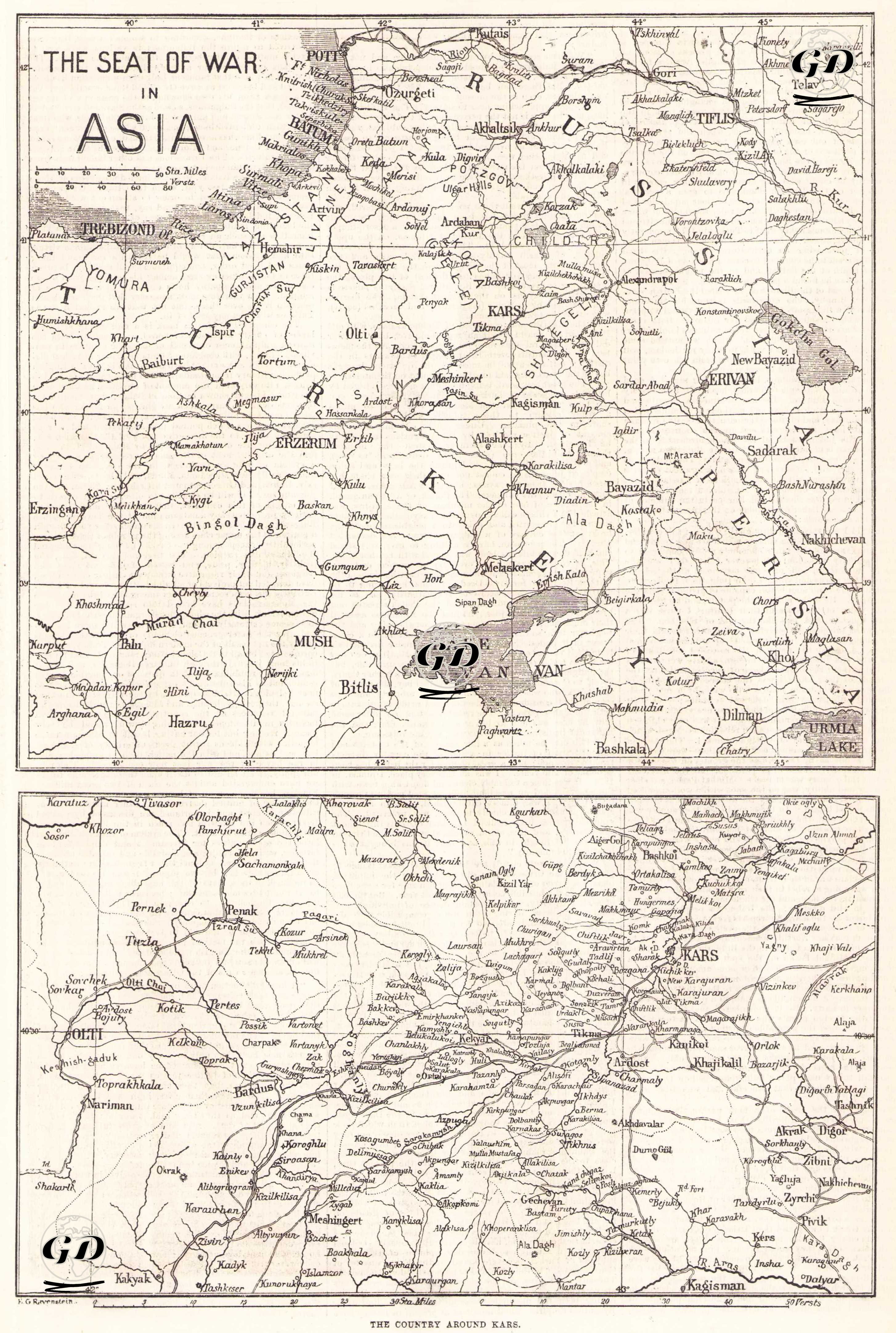
This map shows the most critical geographic areas on the Asian front of the 1877-1878 Russo-Turkish War. Cities such as Kars, Ardahan, Erzurum, Bayezid, Batum, and Trabzon, shown on the map, were strategic centers that formed the main operational lines of the war. The military geography of the Caucasus front directly determined the combat capabilities of both the Ottoman and Russian armies. The Caucasus Mountains are a massive mountain chain stretching from the Black Sea to the Caspian Sea, forming a natural barrier between Europe and Asia. Military roads built by Russia in the 19th century enabled it to bypass the Caucasus barrier and completely control the regions of Georgia and Armenia. As a result of Tsarist Russia's gradual occupation of the Caucasus, which lasted over a century, centers such as Yerevan and Tbilisi came under direct Russian control. Kars and Erzurum, shown on the map, were the main strongholds of the Ottoman Empire's eastern defensive line. Kars, with its multi-line fortifications, forts, and high plateau, was a key point in the Caucasus Wars. Erzurum, on the other hand, was the largest military base opening into the interior of Anatolia. The route between these two cities was the scene of intense fighting and sieges throughout the war. Black Sea ports such as Batumi and Trabzon were key points on the Ottoman military supply routes. Russia's attempts to infiltrate Anatolia via the Caucasus increased the strategic value of controlling these ports. The map below shows in detail the topography, villages, roads, and forts surrounding Kars. This map provides a detailed view of the region known in war literature as the "Kars Basin," which witnessed some of the most intense military activity of the 19th century. The terrain around Kars exhibits a complex geomorphology, with high plateaus, deep valleys, and parallel mountain ranges. This directly influenced the course of the war, limiting the mobility of the armies and highlighting the use of siege warfare. Kale-i Kars (Kars Castle) and the surrounding forts (e.g. Kanlı Tabya, Karadağ, Topçular, Hamzagazi, etc.), located on the map, are among the most advanced defense systems of 19th-century military architecture. These forts formed the most advanced points of the Ottoman eastern defensive line. Furthermore, settlements such as Ardahan, Oltu, Kağızman, Digor, and Sarıkamış, shown on the map, are critical for understanding the Russian army's advance lines and the Ottoman retreat and regrouping zones. The fall of Kars in the 1877 war consolidated Russia's dominance in the Caucasus and directly influenced the final terms of the Berlin Treaty.