GRAVÜR DÜNYASI
Digital Engraving Library
| Artist | Thunot Duvotenay (1796-1875) |
| Engraver | Delsol |
| Date | 1843 |
| Technique | Copper Engraving |
| Category | Maps |
| Source | Mexique et Guatemala par M.De Larenaudiere, Peru par M.Lacroixd, Paris, Firmin Didot Freres, Editeurs, Imprimeurs Libraires de L'Institut de France |
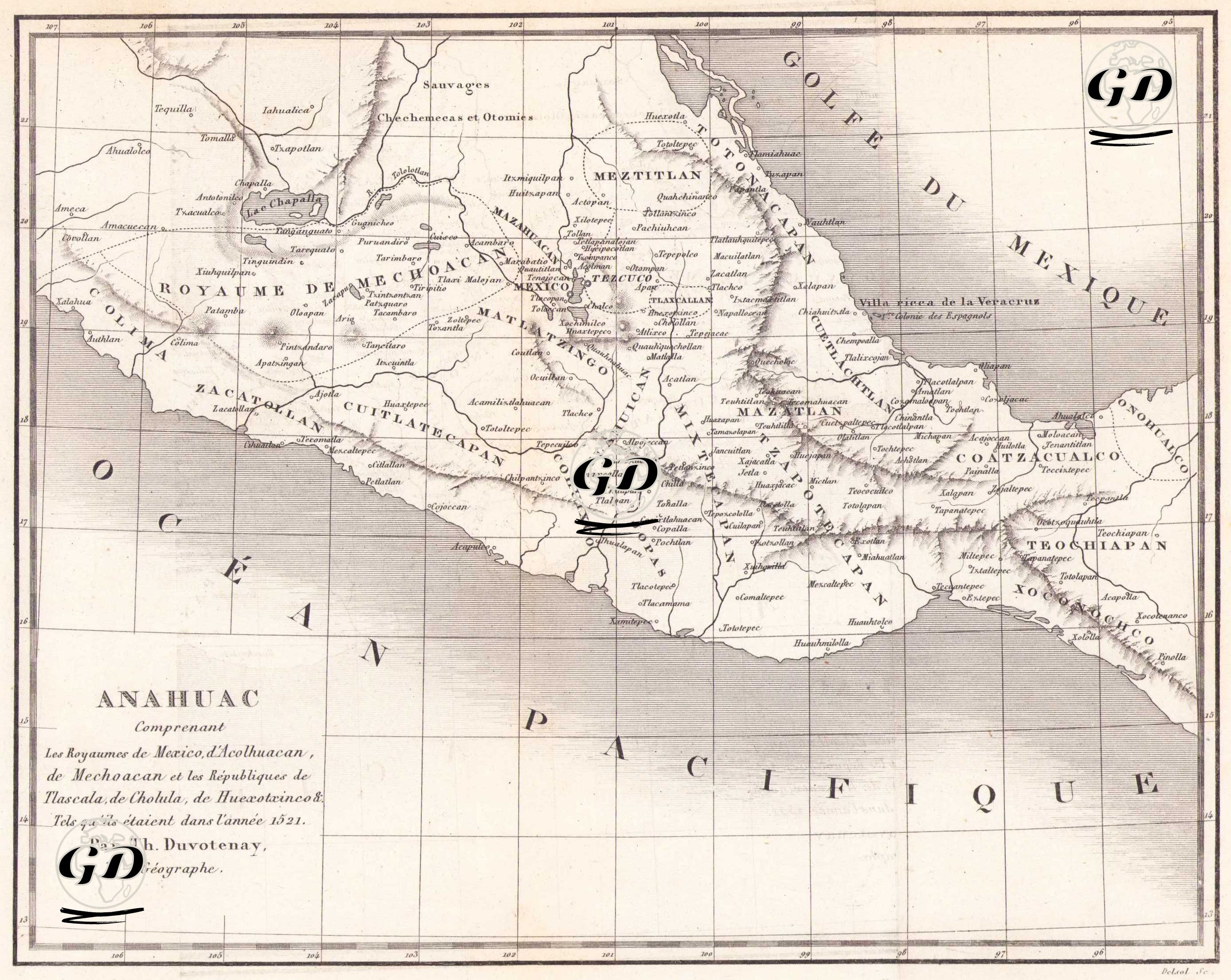
This 1843 map titled “Anahuac,” prepared by the French geographer Thunot Duvotenay, reflects the ancient Mesoamerican political structures and settlements that formed the center and periphery of the Mexican plateau, particularly as they existed in the early 16th century (approximately 1521), before the Spanish conquest. The map is notable for both its ethnohistorical and geographical aspects, and particularly illustrates the geographic distribution of the Aztecs, Tlascaltecs, Cholultecs, Mechouacan, and other Mesoamerican indigenous civilizations. The map encompasses the vast, mountainous region between the Ocean Pacific (Pacific Ocean) to the west, extending as far as the coast of Colima, and the Golfe du Mexique (Gulf of Mexico) to the east. At the center of the map, Lac de Chapala (Lake Chapala) and the surrounding major cities and settlements reveal that this was the economic and political center of the region. To the north, there are areas indicating ethnic communities such as the Sauvages (savages) and the Chichimecas et Otomis; In the south, warmer and coastal settlements such as Teochiapan and Yopitzingo are seen. The map is divided into historical-political regions, such as Royaume de Mexico (Kingdom of Mexico), Royaume de Mechouacan, Royaume de Tezcuco, Republic of Tlascala, Cholula, and Huexotzinco, located on the Anahuac plateau, which corresponds to the center of present-day Mexico. These region names represent the major city-states and kingdoms of the Aztec Empire. The political structures depicted on the map document the ethno-political organization, particularly before the Spanish conquest of 1521. The Aztec domain, centered on Mexico (Tenochtitlan), appears as the largest and most densely populated area on the map, along with surrounding settlements, both allied and hostile, such as Tlascala. Settlements such as Mazatlan, Cuetlachtlan, Cuitlatecapan, Zacatlan, Coatzcoalco, and Teochiapan represent regional centers of various indigenous communities. The map clearly depicts the region's mountainous terrain, with central valleys and mountain ranges being particularly prominent. Place names, derived from indigenous languages before the Spanish conquest, are rendered on the map in their original Nahuatl and other Mesoamerican languages, making the map not only a geographical but also an ethnolinguistic resource.