GRAVÜR DÜNYASI
Digital Engraving Library
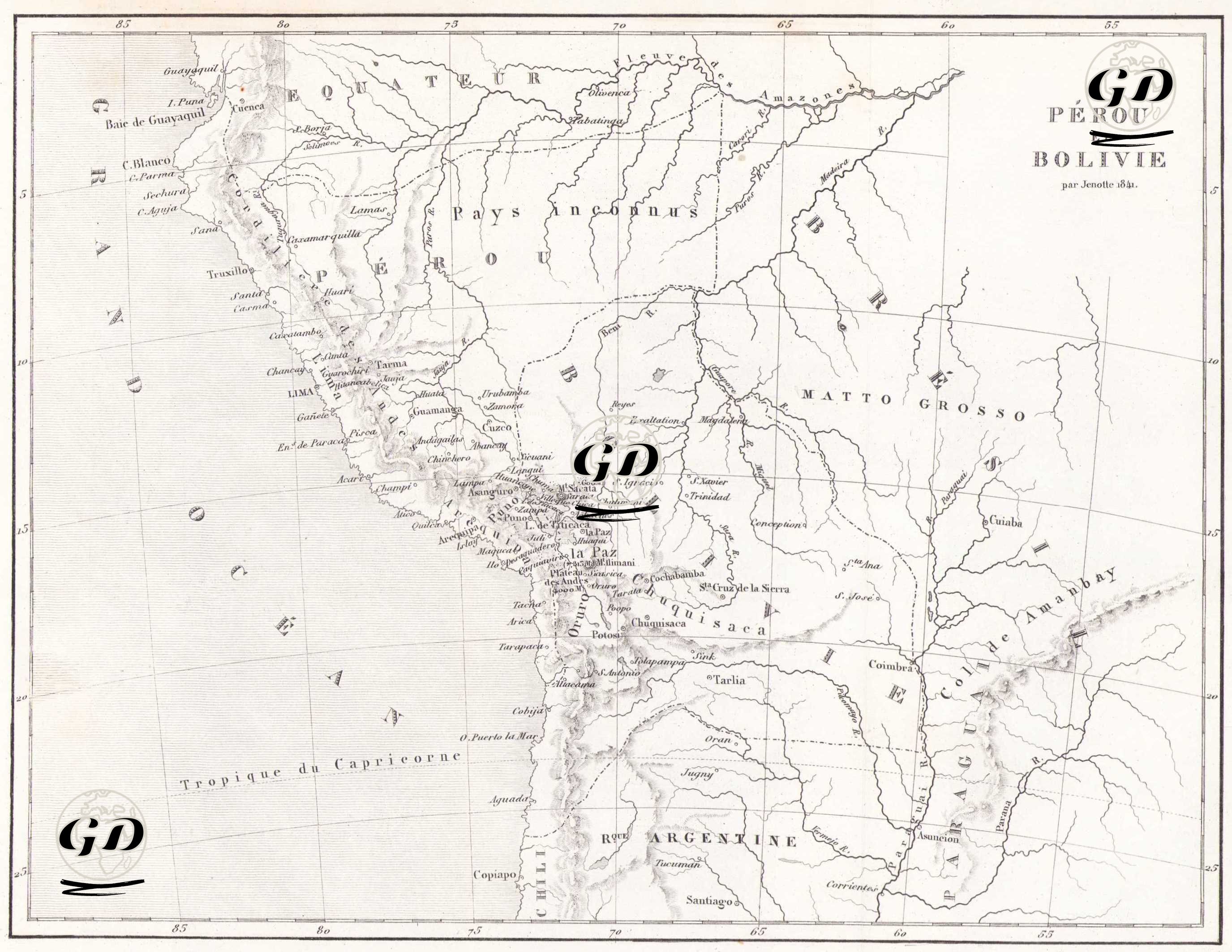
| Engraver | Jenotte |
| Date | 1843 |
| Technique | Copper Engraving |
| Category | Maps |
| Source | Mexique et Guatemala par M.De Larenaudiere, Peru par M.Lacroixd, Paris, Firmin Didot Freres, Editeurs, Imprimeurs Libraires de L'Institut de France |
This map dated 1843, encompassing the western and inland regions of South America—Peru, Bolivia, Ecuador, and parts of Brazil and Argentina—reflects the geographic and political landscape of the period. The map provides information on both the coastal and inland regions, including the topography and hydrological system, while also reflecting the Eurocentric perspective of exploration and colonialism. The western border of the map is marked by the Grand Ocean (Pacific Ocean), while the eastern side encompasses Brazilian inland regions such as Cujaba, Matto Grosso, and Collines d'Amabay. The map begins at the Ecuadorian border in the north and extends south to the Kingdom of Argentina (Kingdom of Argentina). The Tropic of Capricorn line is clearly shown in the southern part of the map, serving as an important reference for geographical positioning. The map clearly reflects the rugged terrain along the Andes. The coastal cities of western Peru, along with the highland mountains and inland plateaus, are clearly shown. Important rivers such as the Amazonas, Ucayali, Madeira, Mamore, and Guapore are drawn in detail along with their sources, demonstrating the map's hydrological orientation. Numerous settlements are marked on the map with their French names. In Peru, prominent cities such as the capital Lima (nearby "Ence de Lima"), Arequipa, Cuzco, Huancavelica, Truxillo (Trujillo), and Guamanga (Ayacucho) are prominently displayed. Within Bolivia, centers such as La Paz, Oruro, Cochabamba, Sucre, Potosí, Santa Cruz, and Tarija are notable. These cities stand out as administrative centers and locations of mining operations. Potosí, in particular, was known as a major silver mining center during the Spanish colonial period from the 16th century onward; the map highlights this city and its surroundings, along with their mountainous terrain, emphasizing their economic importance. The term "Pays Incognus" (unknown lands) is used on the map to refer to some unexplored regions of the Amazon basin. While this statement reflects the lack of knowledge of the interior of South America among European cartographers of the period, it also reflects the interest in exploring these areas. This is particularly supported by the indistinct nature of the Amazon rainforest in the northeast of the map. The map also depicts some extensions of the Cordillera des Andes (Andes Mountains) system, as well as elevations within Brazil, such as the Collines d'Amabay. Political boundaries are quite vague, and modern national borders are not clearly demarcated. This suggests that the map was prepared primarily for physical geography, hydrography, and exploration purposes. Most place names retain their Spanish origins but are presented in French transliterations.