GRAVÜR DÜNYASI
Digital Engraving Library
| Artist | Thunot Duvotenay (1796-1875) |
| Engraver | Delsol |
| Date | 1843 |
| Technique | Copper Engraving |
| Category | Maps |
| Source | Mexique et Guatemala par M.De Larenaudiere, Peru par M.Lacroixd, Paris, Firmin Didot Freres, Editeurs, Imprimeurs Libraires de L'Institut de France |
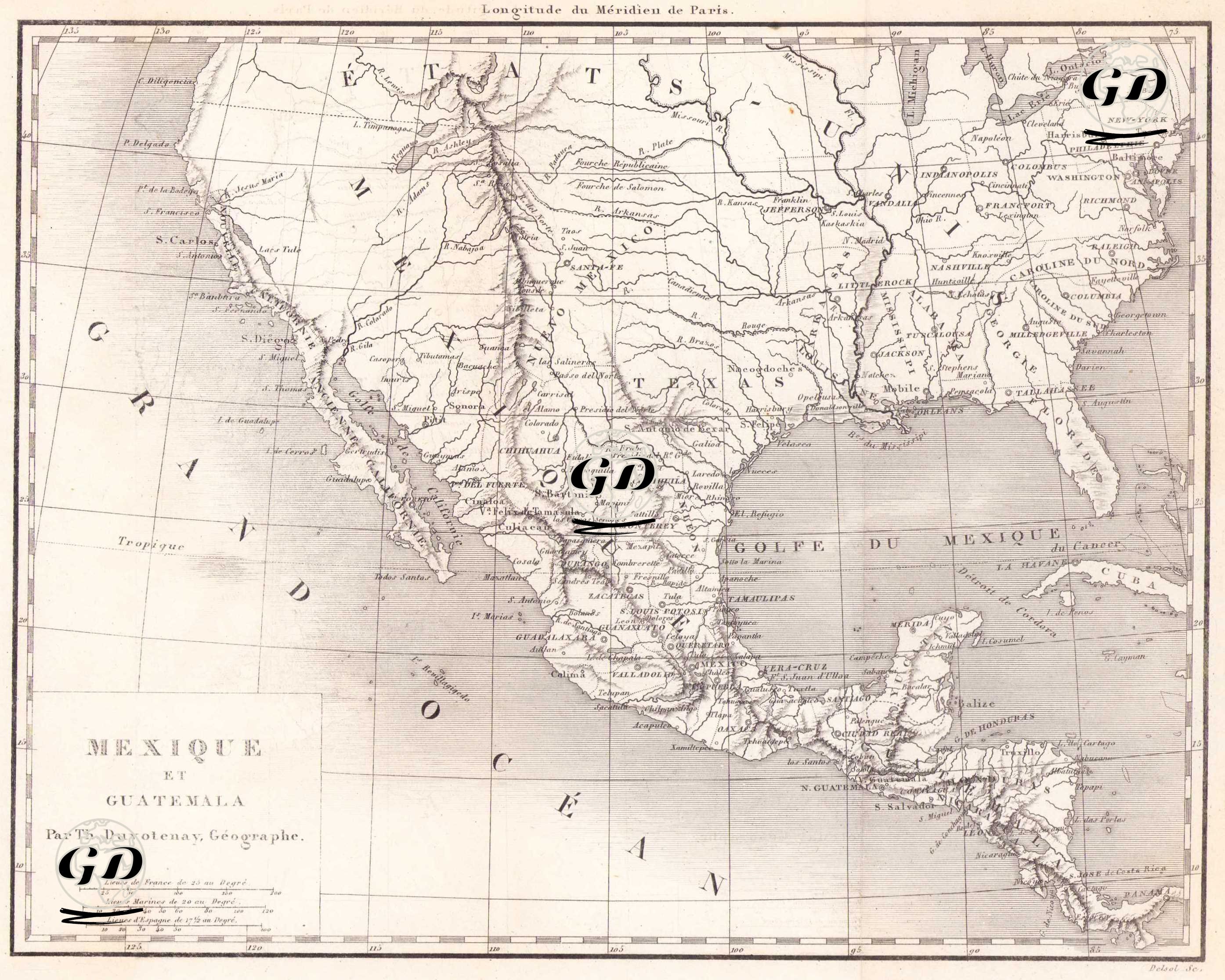
This 1843 map, titled "Mexique et Guatemala," prepared by French geographer Thunot Duvotenay, provides a detailed depiction of the political and geographic structure of Mexico and Central America in the mid-19th century. The French-language map encompasses a vast region stretching from the southern states of the United States (États-Unis) in the north to the Isthmus of Panama in the south. The coastline, mountain ranges, rivers, and settlements that stretch along the continent from northwest to southeast are carefully marked. At the center of the map is Mexico, which at the time still largely preserved its territorial integrity. The capital, Mexico City, is marked as the most important city, and other prominent urban centers such as Puebla, Querétaro, Guanajuato, Guadalajara, Zacatecas, Durango, San Luis Potosí, and Vera Cruz are shown surrounding it. The words "Gulf of Mexico" (Gulf of Mexico) are clearly visible along Mexico's eastern coast, and "Grand Ocean" (Pacific Ocean) are clearly visible on the western coast. The regions in the north of Mexico, which today belong to the United States but were Mexican territory at the time, are noteworthy. On the map, regions such as Texas, New Mexico, California, and Arizona appear to be still part of Mexico, reflecting a period before the Mexican-American War of 1846–1848 and the Treaty of Guadalupe Hidalgo in 1848, before Mexico lost vast territories to the United States. For example, cities such as San Antonio, El Paso, Santa Fe, Tucson, San Diego, and Monterey are marked on the map, clearly demonstrating the border realities of the period. The southern part of the map encompasses Central America, showing in detail the regions encompassing modern-day Guatemala, Honduras, El Salvador, Nicaragua, and Costa Rica. The unification of these countries reveals that these regions were not yet fully separated politically after gaining independence from Spain in the 1820s. Cities and settlements such as Guatemala, San Salvador, Tegucigalpa, Comayagua, Leon, Granada, Cartago, and Panama are included here. Central America is shown mostly by geographical designation and city-by-city, suggesting that the map focuses on geographic and settlement networks rather than political units. Havana is clearly shown in the east of the map. This marks the center of the island of Cuba. The map is an important resource for understanding the period's perceptions of borders, territorial integrity, and the regional tensions that persisted during that period, particularly in the context of Mexico-US relations.