GRAVÜR DÜNYASI
Digital Engraving Library
| Artist | Salomon Munk (1803-1867) |
| Date | 1845 |
| Technique | Copper Engraving |
| Category | Maps |
| Source | Palestine, Description Geographique, Historique et Archeologique par Salomon Munk - Firmin Didot Freres (Paris) |
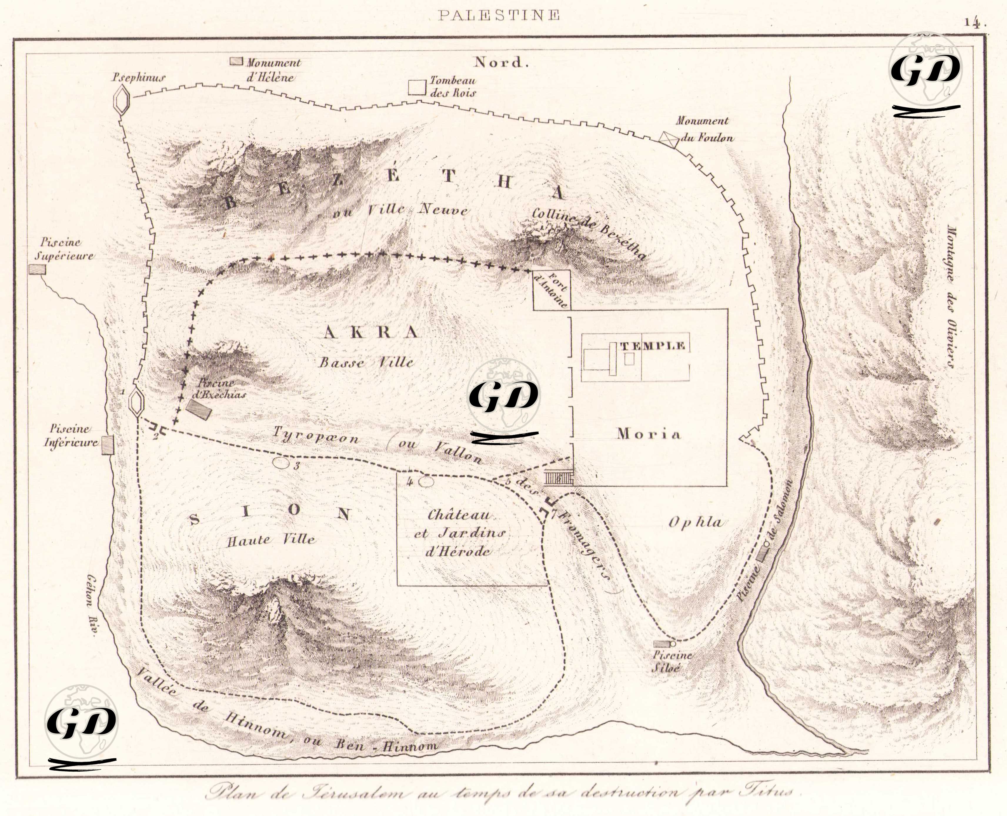
This map is a detailed topographic plan depicting the appearance of Jerusalem when it was destroyed by the Roman General Titus in 70 AD. The engraving, titled in French as "Plan de Jérusalem au temps de sa destruction par Titus", shows in detail the most important structures, neighborhoods and natural geographic elements of ancient Jerusalem. It is positioned so that the north is at the top of the map. To the east, the Mount of Olives (Montagne des Oliviers) and the Kedron Riv. are clearly drawn. Between this mountain and the city, the Mount of Moria and the Temple on it are particularly striking. The Temple is the holiest site in Jerusalem and the First and Second Temples for the Jews were built here. To the east of the Temple is the Ophla region and to the south is the Palace and Gardens of Herod (Château et Jardins d’Hérode). As we move west, we come across the region known as Sion (Sion – Haute Ville), or the high city. It is located on a high hill where the aristocratic class of the city lives. Accra (Accra - Basse Ville) is defined as the lower city where the middle class people live, at a lower elevation. The map also shows the “new city” section, known as Bezétha, to the north, which was a developing suburb of Jerusalem at the time. The Tyropœon Valley (ou Vallon), which winds through the middle of the city, separates the eastern and western parts of the city like a natural border. To the south, the Hinnom Valley (Vallée de Hinnom ou Ben Hinnom) is a symbolic region identified with hell in Jewish and Christian sources. The map is also rich in historical structures. Monuments such as the Tombeau des Rois (Tomb of the Kings), the Monument d’Hélène and the Monument du Foulon are marked. Pools (Piscine Supérieure, Piscine Inférieure, Piscine Siloe) and important passes and waterways are also detailed. This map is a reconstruction based on both archaeological and religious texts, and provides important visual evidence of the final periods of Jerusalem under the siege of the Roman Empire.