GRAVÜR DÜNYASI
Digital Engraving Library
| Artist | Alexandre Vuillemin (1812-1880) |
| Engraver | Erhard Schieble (1821-1880) |
| Date | 1866 |
| Technique | Steel Engraving-Original Hand Colored |
| Category | Maps |
| Source | Atlas Universel D'Histoire et de Geographie (Atlas of Universal History and Geography - Librairie-Hachette Et Cie A paris. Imp.E.Dufrenay |
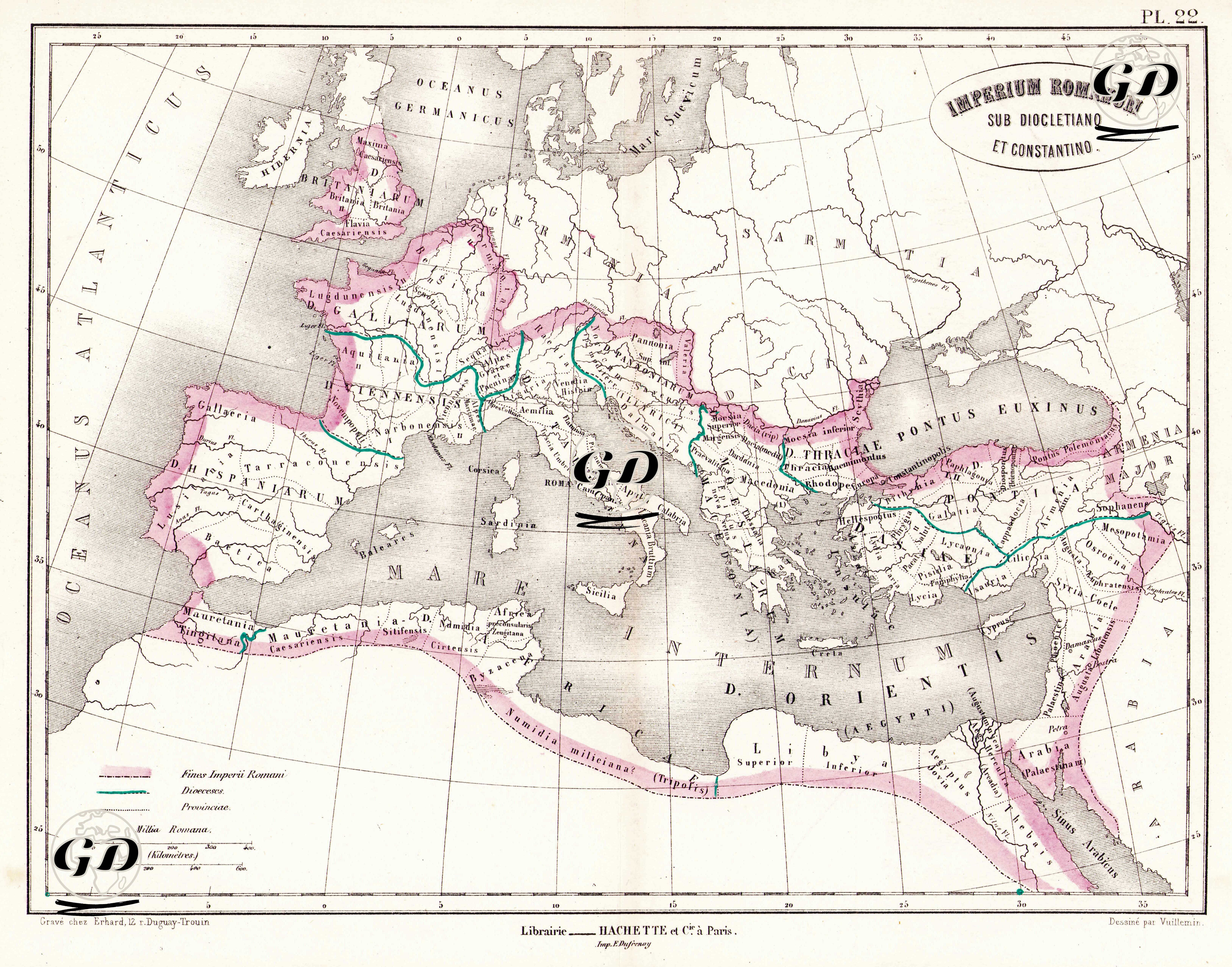
This map is a detailed and color-coded historical cartographic work reflecting the political and administrative structure of the Roman Empire during the reigns of Diocletian and Constantine (approximately AD 284–337). It serves as a visual representation of the empire's transition from the classical Roman model to a more centralized and divided system of governance. The pink borders indicate the full territorial extent of the Roman Empire at the beginning of the 4th century AD, stretching from Britain to Egypt and from Spain to Mesopotamia—one of the largest expansions in Roman history. The green line represents the East–West division initiated by Diocletian and later solidified by Constantine. This demarcation highlights the administrative separation into Western Rome and Eastern Rome (Byzantium). Black lines on the map denote the major Roman roads (milites Romani), which were crucial for maintaining military, commercial, and administrative cohesion across the empire. From Britannia and Hispania in the west to Mesopotamia and Egypt in the east, and from the Rhine River in the north to the North African coast in the south, the empire was no longer governed from a single capital but instead from two major administrative centers: Rome in the West and Nicomedia (later Constantinople) in the East. The structure established under Diocletian’s Tetrarchy system, later reformed by Constantine, laid the foundations for what would eventually become the Byzantine Empire. This transformation is clearly depicted on the map: the green boundary line separates the Latin-dominated Western world from the Greek and Eastern cultural geography of the East. In addition, the map emphasizes the vast infrastructure of Roman roads, illustrating how the empire managed military logistics and commercial integration across such a vast and diverse territory. Beyond its value as a reference in ancient geography, this map captures the spatial reflection of Rome’s administrative strategies developed in response to political crises, economic decline, and external threats. It is a vivid illustration of how geography and governance were intertwined in shaping the later Roman world.