GRAVÜR DÜNYASI
Digital Engraving Library
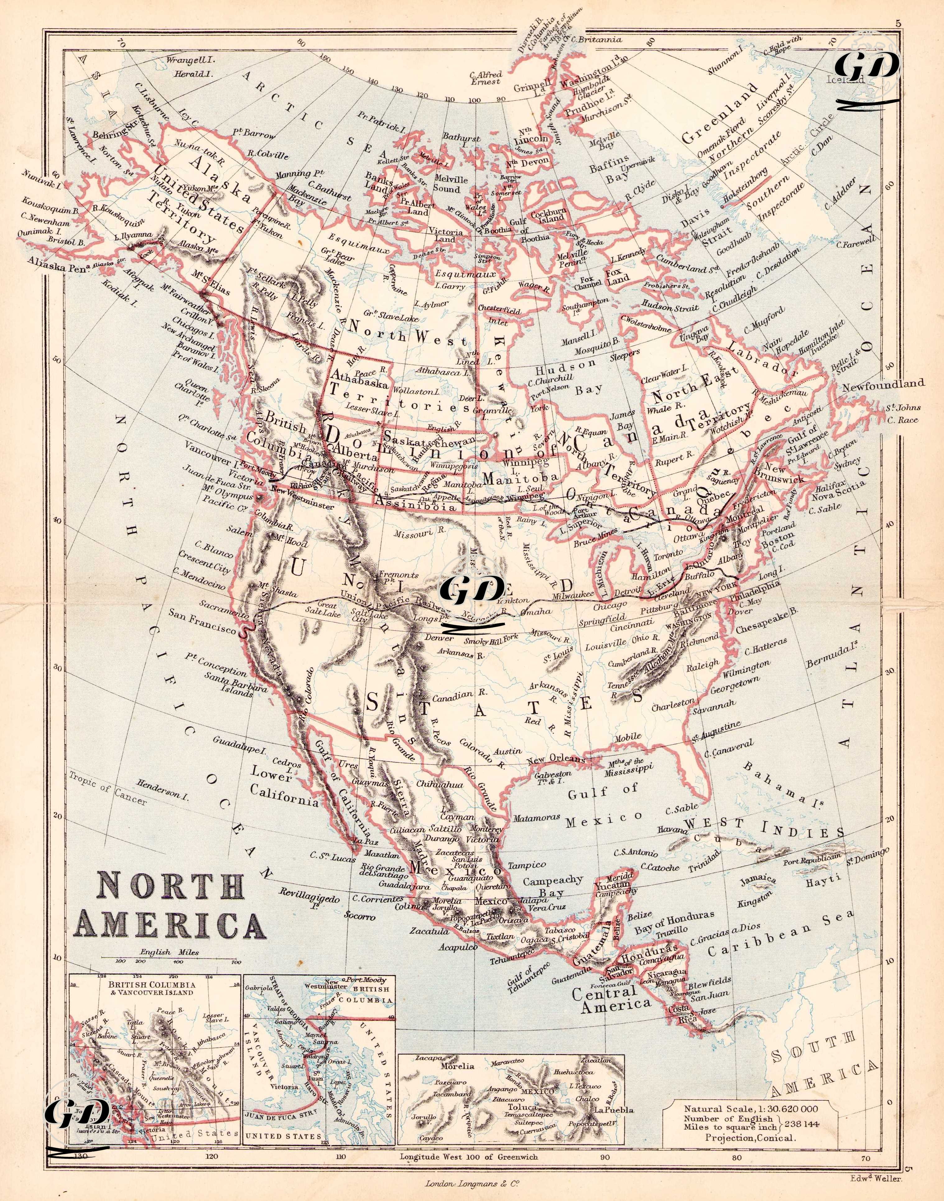
| Engraver | Edward Weller (1819-1884) |
| Date | 1874 |
| Technique | Steel Engraving-Original Hand Colored |
| Category | Maps |
| Source | The Public Schools Atlas of Modern Geography in 31 Maps. Exhibiting Clearly the More Important Physical Features of the Countries Delineated and Noting All the Chief Places of Historical, Commercial, or Social Interest; Rev. George Butler - London: Longmans & Co. |
This 1874 map depicts a period when the modern national borders of the North American continent were just beginning to take shape, particularly the westward expansion of the United States, the federalization of Canada, and the transformation of Mexico's borders. North America is presented on the map in a conical projection at a scale of 1:30,620,000, and the notation "Miles to one square inch: 324.14" indicates the distance per square mile in English units. The map shows the united United States, but some states in the west appear to be incomplete. Areas such as Colorado, Arizona, and New Mexico are shown as territorial. Alaska is shown on the map as "Alaska (United States Territory)," indicating that the US, which purchased the territory from Russia in 1867, had not yet fully established itself as a state. Canada does not yet appear to have fully transitioned to a province system, but instead regional distinctions such as Hudson's Bay Territory, North-West Territories, Saskatchewan District, British Columbia, Ontario, Quebec, and Nova Scotia are used. This document documents Canada's geographical transformation during the Confederation process. Countries such as Guatemala, Honduras, El Salvador, Nicaragua, and Costa Rica are shown as independent. Panama is still part of Colombia. The Caribbean Islands appear as important colonial territories. Cuba and Puerto Rico remain under Spanish control, while Haiti and the Dominican Republic are independent. Three separate inset maps appear at the bottom of the map: 1. British Columbia and Vancouver Island; a detailed view of the colonial territory on Canada's west coast. 2. The Isthmus of Panama; a detailed map depicting the isthmus and its surrounding area where the Panama Canal will be built, emphasizing its strategic importance. 3. Mexico and Central America; a mountainous topographic inset showing the physical structure of Mexico and Central America.