GRAVÜR DÜNYASI
Digital Engraving Library
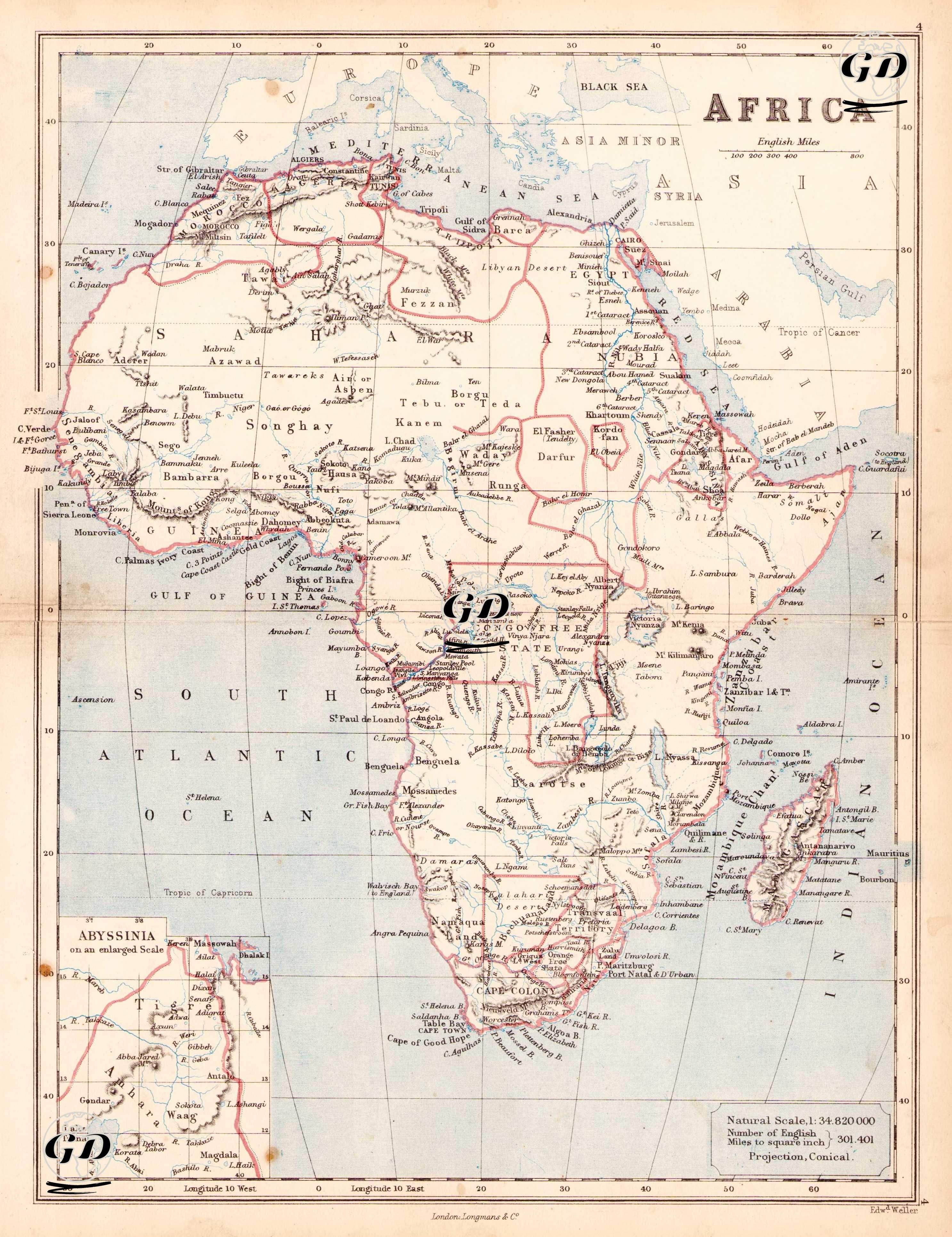
| Engraver | Edward Weller (1819-1884) |
| Date | 1874 |
| Technique | Steel Engraving-Original Hand Colored |
| Category | Maps |
| Source | The Public Schools Atlas of Modern Geography in 31 Maps. Exhibiting Clearly the More Important Physical Features of the Countries Delineated and Noting All the Chief Places of Historical, Commercial, or Social Interest; Rev. George Butler - London: Longmans & Co. |
This 19th-century colonial map depicts the political and geographic structure of the African continent during the pre-colonial and early colonial periods in the last quarter of the 19th century, at a scale of 1:34,820,000, using a conical projection. This map was prepared at the beginning of the period known as the "Scramble for Africa" and reflects the state of Africa before the Berlin Conference of 1884-1885, when it had not yet been completely divided among European powers. Consequently, the interior of Africa was still largely unexplored by Europeans, and many regions were designated only by the names of major tribes or vague geographical names. The red borders on the map indicate specific spheres of influence and administrative districts, as well as areas not yet officially shared by European powers but where they were beginning to establish de facto influence. The African continent is detailed from north to south on the map. In North Africa, regions such as Morocco, Algeria, and Tunisia are seen as political entities under European influence, while Egypt stands out both under Ottoman rule and due to its growing British influence. Moving southeast along the Nile Valley, independent or semi-independent regional powers such as Sudan, Darfur, and Kordofan are shown. Abyssinia (present-day Ethiopia) is enlarged with an inset in the lower left corner of the map, detailing the region's mountainous terrain, cities, and lakes. This region was one of the few African states still independent in the 19th century and not yet colonized by European powers. The Congo Basin in Central Africa was designated the "Congo Free State"; this region was known as the personal property of King Leopold II of Belgium and was one of the most controversial colonial territories formed after the Berlin Conference (1884-85). The Niger River, Lake Chad, and West African settlements and tribal kingdoms such as Bamako, Timbuktu, Bornu, and Sokoto also reflect the ethno-geographical structure of these regions. The Sahara, on the other hand, covers a large area of the map, represented by sparsely settled desert and semi-nomadic communities. In South Africa, names such as Cape Colony, Natal, Transvaal, and Orange Free State attract attention. These regions were particularly at the center of power struggles between the British and the Boers (Dutch settlers). This period predates the Anglo-Boer Wars and represents a period when conflicts between European settlers and indigenous peoples were not yet fully institutionalized, but tensions were rising. Important trading centers such as Zanzibar, Mozambique, and Madagascar are located on the map's eastern coast, suggesting the slave, spice, and ivory trade carried out through these ports by Arab, Indian, and European merchants. Strategic waterways such as the Indian Ocean, the Horn of Africa, and the Mozambique Channel are clearly depicted on the map.