GRAVÜR DÜNYASI
Digital Engraving Library
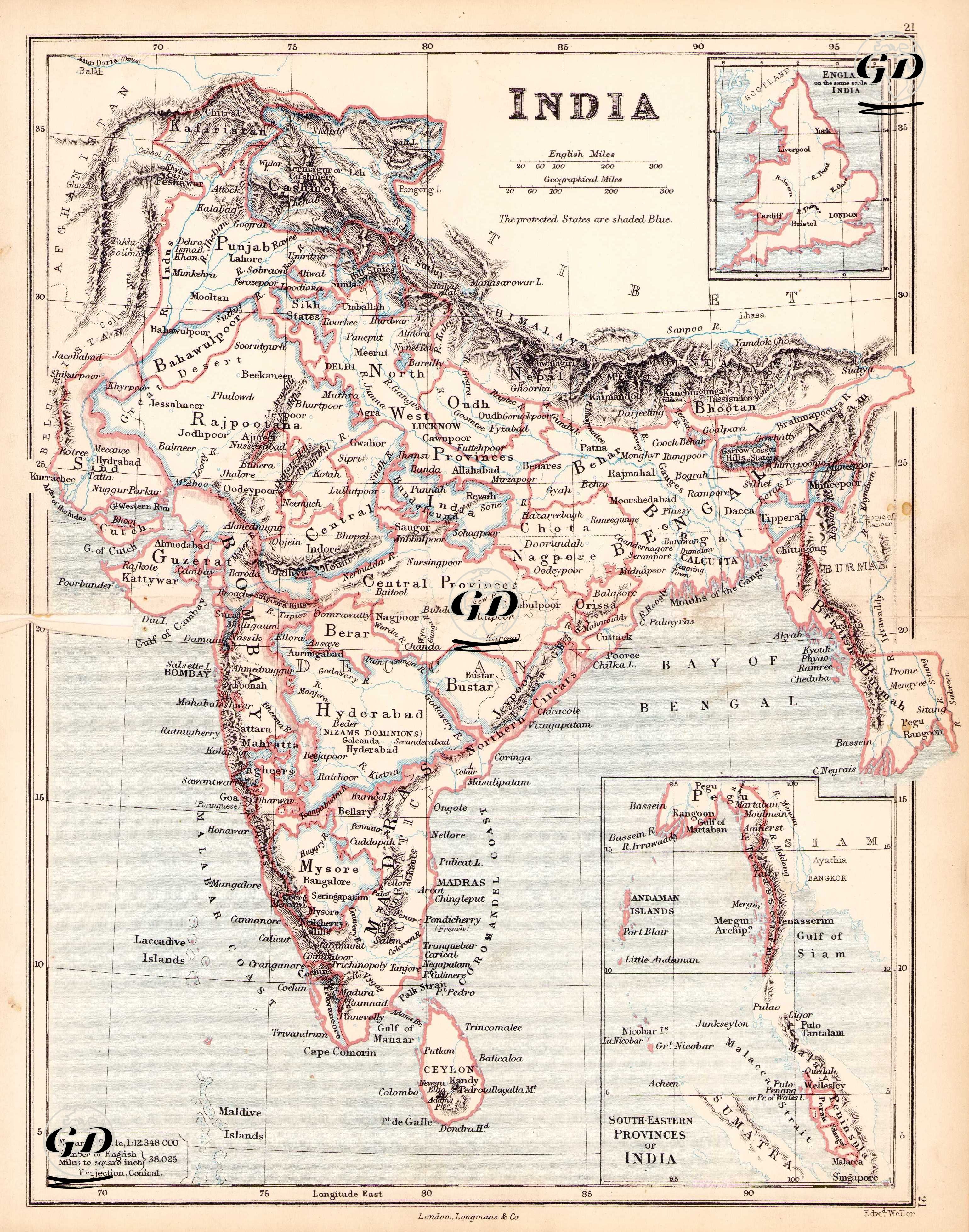
| Engraver | Edward Weller (1819-1884) |
| Date | 1874 |
| Technique | Steel Engraving-Original Hand Colored |
| Category | Maps |
| Source | The Public Schools Atlas of Modern Geography in 31 Maps. Exhibiting Clearly the More Important Physical Features of the Countries Delineated and Noting All the Chief Places of Historical, Commercial, or Social Interest; Rev. George Butler - London: Longmans & Co. |
This is a detailed colonial map depicting the British Empire's rule over India and the political and administrative structure of the Indian subcontinent during the second half of the 19th century. This British colonial map shows the administrative districts of India (e.g., Bengal, Bombay, Madras, and Punjab) in detail at a scale of 1:12,348,000 in a conical projection. Although the map title simply says "INDIA," the area covered is quite extensive: it includes all of present-day India, as well as Pakistan, Bangladesh, Nepal, Bhutan, Sri Lanka (Ceylon), and the western coast of Myanmar. The scale chart in the lower left corner of the map is detailed in both English miles and geographical miles. The map distinguishes between areas under direct British control (red stripes) and protected states. The blue-shaded areas represent local principalities under British control but not under direct sovereignty (e.g., Hyderabad, Mysore, Rajpootana). Among the major regions on the map, administrative units such as Punjab, North-West Provinces, Oudh, Central Provinces, Rajpootana (Rajasthan), Hyderabad (Nizam's Dominions), Berar, Bombay Presidency, Madras Presidency, and Bengal Presidency stand out. These regions reflect the administrative divisions of British India and the structural framework of the colonial system. Furthermore, places such as Mysore, Travancore, Baroda, Bhopal, Gwalior, Jaipur, and Jodhpur are designated as protected principalities. The Himalayas are delineated in detail, and the northern border includes key regions such as the Tibetan plateau, Ladakh, Kashmir, Nepal, and Bhutan, clearly demonstrating British India's northern geopolitical boundaries. In the eastern region, regions such as Assam, Manipur, Chittagong, and Burmah (present-day Myanmar/Birmania) are shown, as are details of the Andaman Islands, Nicobar Islands, Ceylon (Sri Lanka) in the Bay of Bengal, and the Malay Peninsula in the boxed map in the lower right corner of the map. Places such as Penang, Singapore, and Malacca are indicators of Britain's colonial presence in Southeast Asia. This map meticulously depicts not only administrative and political divisions but also trade routes, major port cities, mountain ranges, river systems, and coastlines. For example, major river systems such as the Indus, Ganges, and Brahmaputra are detailed, highlighting their influence on settlement. Major port cities such as Calcutta (Kolkata), Bombay (Mumbai), and Madras (Chennai) stood out as the commercial and military centers of the British Empire. To illustrate the vastness of India for European readers, an inset is provided in the upper right corner, comparing the size of Britain and India.