GRAVÜR DÜNYASI
Digital Engraving Library
| Engraver | Edward Weller (1819-1884) |
| Date | 1874 |
| Technique | Steel Engraving-Original Hand Colored |
| Category | Maps |
| Source | The Public Schools Atlas of Modern Geography in 31 Maps. Exhibiting Clearly the More Important Physical Features of the Countries Delineated and Noting All the Chief Places of Historical, Commercial, or Social Interest; Rev. George Butler - London: Longmans & Co. |
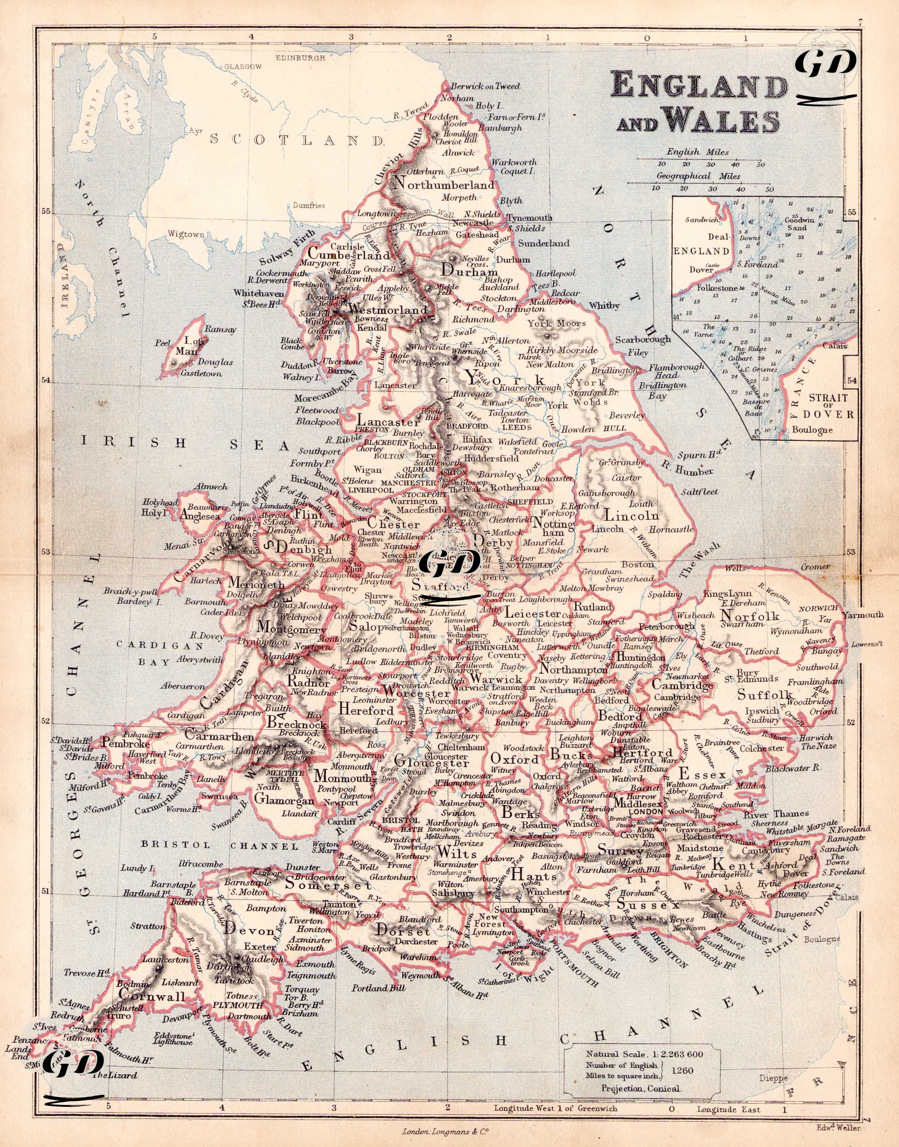
This 1874 map is a highly detailed, period-specific political-service map depicting the administrative boundaries, principal cities, and river and coastline details of England and Wales. The title of the map, prepared using a conical projection, displays "England and Wales" in capital letters, and the scale indicates a "Natural Scale 1:2,623,600" ratio. The red borders on the map, drawn according to the county system of Victorian England, represent the counties of England and Wales. The "shires" on the map were the fundamental building blocks of both the administrative and judicial systems of that period. This structure was reformed by the Local Government Act of 1888, and this map maintains its classical pre-reform structure. Among these counties are numerous administrative regions whose names are still preserved today, such as Yorkshire, Lancashire, Cornwall, Kent, Norfolk, Devon, Essex, Somerset, and Suffolk. Within each county are the principal town and city names written in lower case; for example, "York" and "Leeds" are clearly marked within Yorkshire; "Manchester" and "Liverpool" are clearly marked within Lancashire. London, centrally located on the banks of the River Thames in the southeast, is highlighted and shown within the surrounding county of Middlesex. Similarly, important university and port cities such as Oxford, Cambridge, Bristol, Birmingham, Southampton, and Norwich are also detailed. A box inset in the upper right corner of the map shows the Strait of Dover, the narrowest point in the English Channel, in southeast England, and its surrounding area in greater detail. Port cities such as Dover, Deal, Folkestone, and Sandwich are shown in this section, as well as the strategically located passage between England and France. The seas surrounding the coasts of England and Wales are clearly named: the Irish Sea, St. George's Channel, the English Channel, and the Bristol Channel. Counties within Wales are also carefully delineated and designated with names such as Carnarvon, Cardigan, and Glamorgan.