GRAVÜR DÜNYASI
Digital Engraving Library
| Engraver | Edward Weller (1819-1884) |
| Date | 1874 |
| Technique | Steel Engraving-Original Hand Colored |
| Category | Maps |
| Source | The Public Schools Atlas of Modern Geography in 31 Maps. Exhibiting Clearly the More Important Physical Features of the Countries Delineated and Noting All the Chief Places of Historical, Commercial, or Social Interest; Rev. George Butler - London: Longmans & Co. |
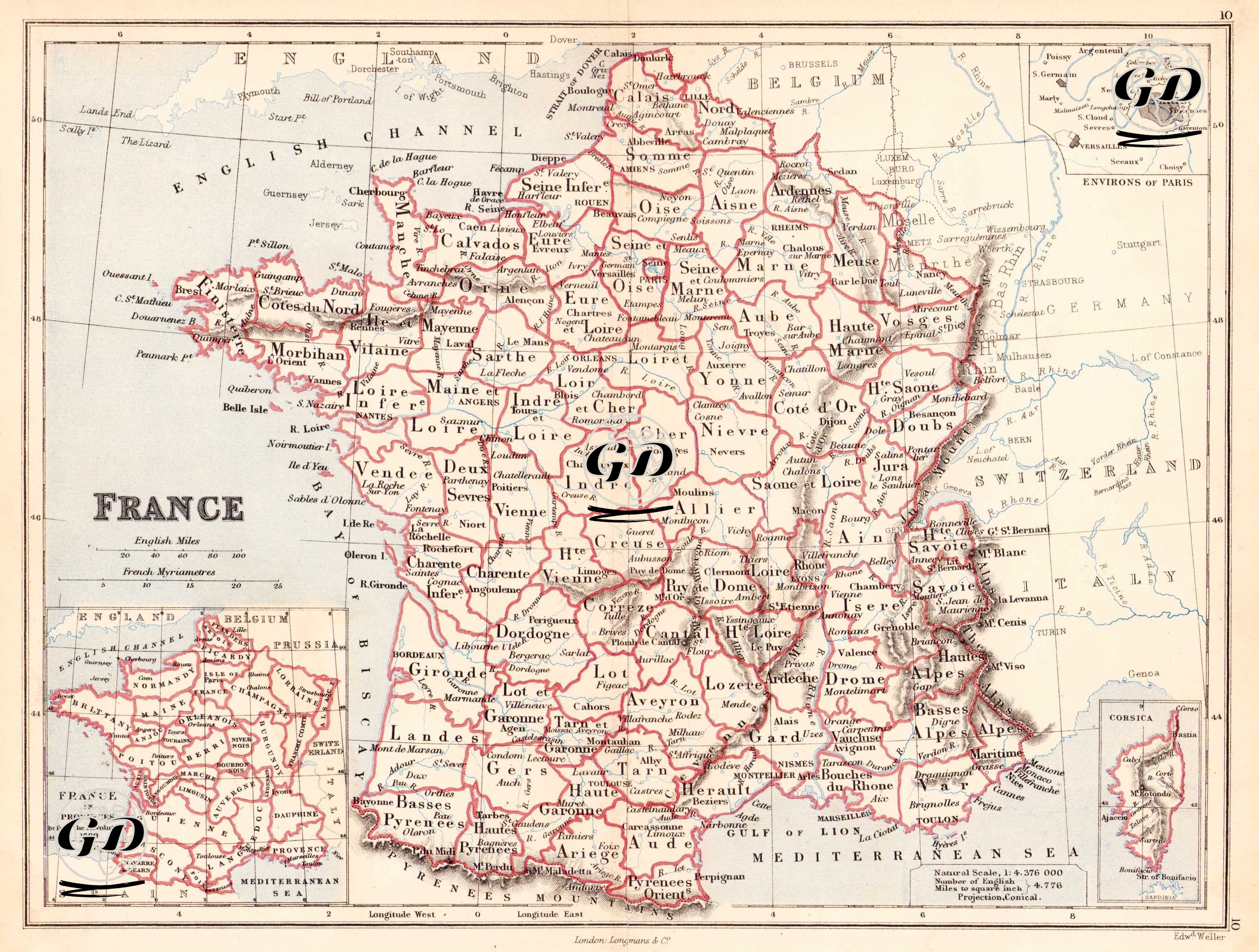
This is a political map from the last quarter of the 19th century, showing the administrative divisions of France in detail. The projection type used is a conical projection, and the scale is 1:4,376,000. The map names the departments that make up France in detail, demarcating their borders with distinct red lines. The administrative areas within these lines are based on the modern "département" system, established in the post-Napoleonic era under the influence of the French Revolution and largely still in effect today. The name of each department is written in capital letters, and the capital cities (e.g., Dijon, Lyon, Nantes, Bordeaux, Marseille) are marked on the map in accordance with the orthographic norms of the period. Regions in northeastern France, such as "Alsace" and "Lorraine," which were historically subject to border disputes between Germany and France, are also shown. In the lower left corner of the map is a separate inset titled "France in Provinces before the Revolution A.D. 1789." This inset shows the traditional provincial structure before the French Revolution—regions such as Brittany, Normandie, Languedoc, Guyenne, Provence, and Dauphine. This inset allows for a comparison of the traditional pre-revolutionary regional structure with the post-revolutionary centralized administrative structure (department). In the lower right corner is a detailed inset of the island of Corsica. Settlements on the island (such as Ajaccio and Bastia) and geographic details are presented on a second inset, separated from the mainland. In the upper right corner of the map is another detailed inset titled "Environs of Paris." This inset shows Paris and its surroundings at a larger scale, making features such as suburbs, forests, and main roads around the capital more readable. Important settlements such as Versailles, St. Germain, and Sèvres are shown in detail. Physical features are also meticulously depicted on the map, including mountain ranges (Alps, Pyrenees, Massif Central), major river systems (Seine, Loire, Rhone, Garonne), lakes, and seashores. The shading technique (hachure), particularly applied to mountainous regions, successfully conveys the perception of topographic elevation.