GRAVÜR DÜNYASI
Digital Engraving Library
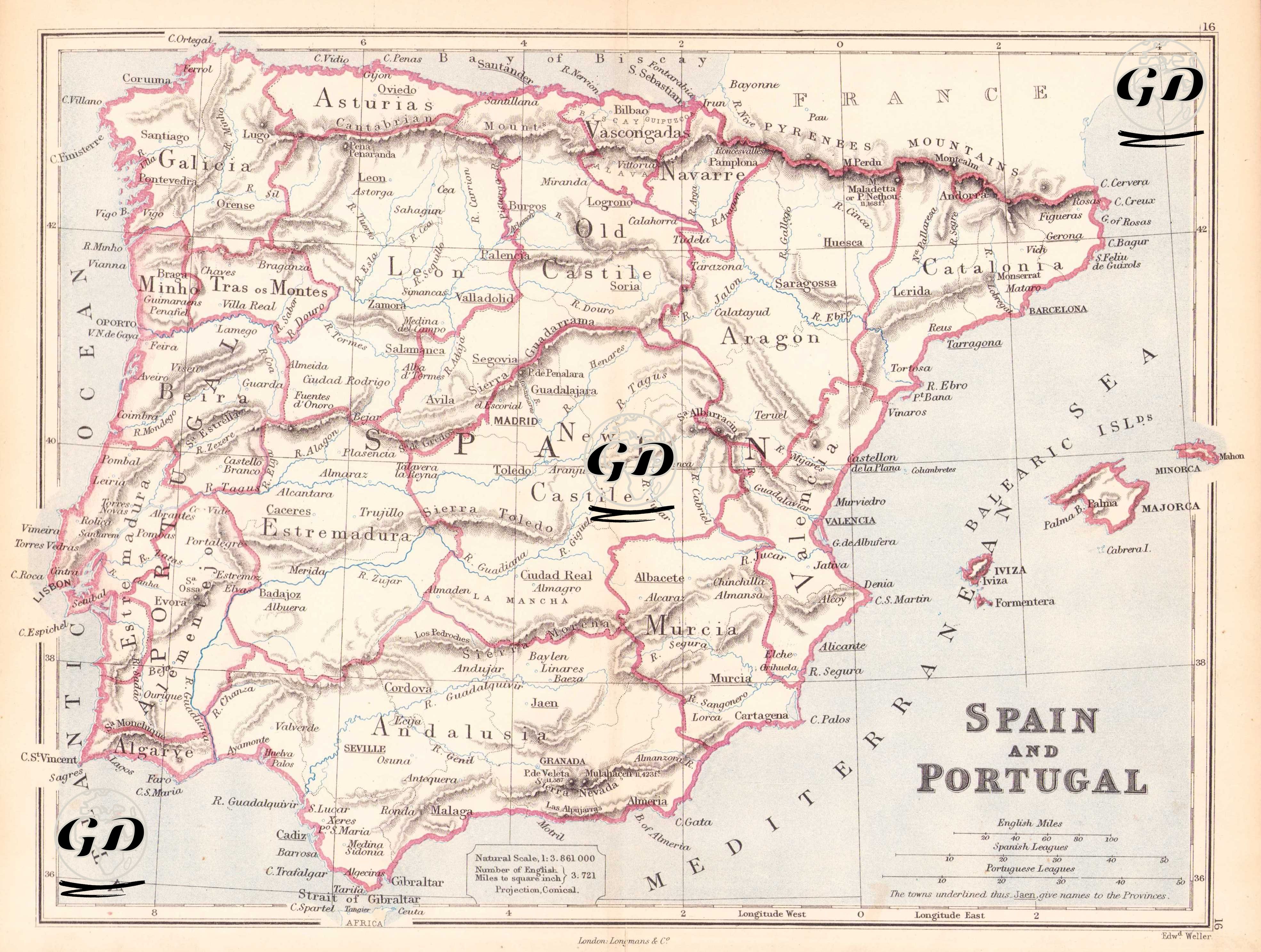
| Engraver | Edward Weller (1819-1884) |
| Date | 1874 |
| Technique | Steel Engraving-Original Hand Colored |
| Category | Maps |
| Source | The Public Schools Atlas of Modern Geography in 31 Maps. Exhibiting Clearly the More Important Physical Features of the Countries Delineated and Noting All the Chief Places of Historical, Commercial, or Social Interest; Rev. George Butler - London: Longmans & Co. |
This map dated 1874 is a detailed physical and administrative map reflecting the political and administrative geography of Spain and Portugal. Prepared by Edward Weller and published by the London-based Longman & Co. publishing house, the title in the lower right corner of the map reads "Spain and Portugal," and the scale is 1:3,861,000. The legend also provides scale comparisons with English miles, Spanish miles, and leagues. The projection type is conical. All major administrative regions, mountain ranges, and major river systems of the Iberian Peninsula are shown in detail on the map. The regions that are the historical ancestors of the autonomous communities of modern Spain are clearly demarcated: for example, regional names such as “Galicia”, “Asturias”, “Leon”, “Castile”, “Navarra”, “Catalonia”, “Aragon”, “Valencia”, “Murcia”, “Andalusia”, “Estremadura” are correctly positioned in both historical and geographical contexts. Similarly, Portugal is listed from the regions of "Minho" and "Tras os Montes" in the north to the south as "Beira," "Estremadura," "Alentejo," and "Algarve," each with its major rivers (e.g., the Douro, Tagus, and Guadiana). The Strait of Gibraltar is shown at the bottom of the map, and the word "Africa" on the opposite shore indicates the beginning of the North African coast. Physical details are also quite clear: mountain ranges such as the Pyrenees Mountains, the Cantabrian Mountains (Cordillera Cantabrica), and the Sierra Nevada are depicted in relief. Furthermore, major river systems and valleys such as the Ebro, Douro, Guadalquivir, and Tagus (Tagus) are depicted in detail. The Balearic Islands (Majorca, Minorca, Ibiza, and Formentera) are shown along the coastline, each named after its unique location. In the center of the map, Madrid is indicated as the capital, and other important cities around it (Toledo, Valladolid, Zaragoza, Valencia, Seville, Cordoba, Granada, Barcelona) are presented in the spelling of the period. A small note on the map also indicates that the underlined city names are also the settlements that gave their name to the province or region. For example, city names like "Leon," "Toledo," "Valencia," and "Barcelona" are presented this way.