GRAVÜR DÜNYASI
Digital Engraving Library
| Artist | Heinrich Theodor Menke (1819-1892) |
| Date | 1866 |
| Technique | Copper Engraving-Original Hand Colored |
| Category | Maps |
| Source | Orbis antiqui descriptio [cartographic material] : an atlas illustrating ancient history and geography by eighteen maps by Heinrich Theodor Menke - Published by Justus Perthes, Gotha |
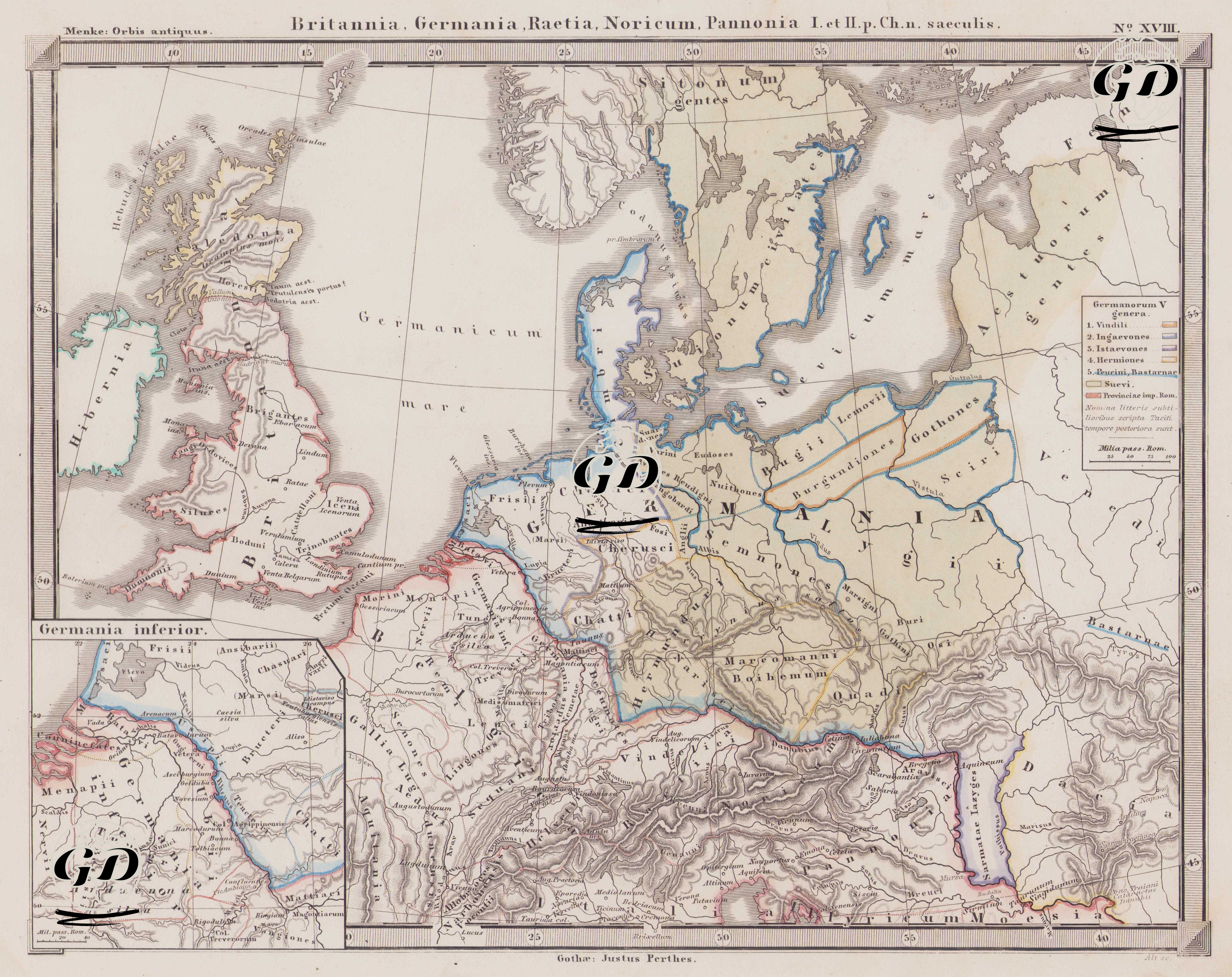
This map is a historical ethnographic and geographical document showing the distribution and classification of Germanic tribes living in the northern regions of Europe during the Roman Empire. The title of the map is “Britannia, Germania, Raetia, Noricum, Pannonia I. et II. p. Ch. n. saeculis” and indicates that it reflects the situation of these regions especially in the 1st and 2nd centuries AD. The map was prepared based on the work of the famous historian Tacitus called Germania and was shaped specifically with the principle of dividing the Germanic peoples into five main groups. The names of these peoples are given in the legend in the upper right corner under the title “Germanorum V genera” or “five groups of Germans”. These are: 1. Vindili; A Germanic community generally thought to have lived around the Oder River, who would later be known as the Vandals. 2. Ingaevones; Tribes that lived in the north, close to the coast of the North Sea; Peoples such as the Frisians and Chauci are included in this group. 3. Istaevones; They settled around the Rhine River and included peoples such as the Bructeri and Tencteri. 4. Hermiones were more centralized Germanic peoples who lived in the interior regions of Germany, around the Elbe River. Examples of this group include the Suebi, Harudes, and Hermunduri. 5. Peucini and Bastarnae are border peoples living east of the Carpathian Mountains, with mixed Gothic and Sarmatian characteristics. The legend also highlights the "Suevi" people, indicating their significant and extensive confederation within the Germanic tribes. The map color-coded the borders of these tribes, making it easy to follow both Tacitus's classification and their geographical location. Another important note is the small, thinner font of some place names on the map. As stated in the legend, "Nomina litteris subtilioribus scripta Taciti tempore posteriora sunt" means "the thinner names date from after Tacitus's time." This demonstrates that the map considers not only the Tacitian era but also subsequent developments; for example, early traces of Goth, Burgundian, and Vandal movements are captured in this way. The map shows not only the Germanic peoples but also the border provinces of the Roman Empire in detail. These provinces are defined in the legend under the heading "Provinciaea imp. Rom.", and the areas outlined by red lines on the map represent Roman provinces. Of particular note are the provinces of Britannia, Germania Inferior, Germania Superior, Raetia, Noricum, and Pannonia. Roman contact with the Germanic peoples was most intense in these regions, and the Limes Germanicus (Roman wall line) was established to secure these areas. The British Isles are also shown in detail on the map, and the Roman-held Britannia region is outlined in red. Cities such as Londinium, Eboracum, and Camulodunum demonstrate Roman influence, while Caledonia in northern Scotland was outside Roman direct control. In continental Europe, Roman border garrisons, military routes, and trade lines are clearly shown, particularly along the Danube and Rhine rivers. Germanic peoples, however, live within the natural geography (forests and rivers) immediately north of these borders. Sonuç olarak, bu harita yalnızca Roma İmparatorluğu’nun coğrafi sınırlarını değil, aynı zamanda Roma'nın gözünden barbar dünyayı – yani Germen halklarını – sınıflandıran ve düzenleyen önemli bir belge niteliğindedir. Tacitus’un Germania adlı eserinden doğrudan esinlenerek hazırlanmış bu kartografik yapı, Roma'nın kuzey sınırlarındaki etnografik düzeni, stratejik eyalet yapılanmasını ve kültürel-halklar haritasını bütüncül biçimde yansıtmaktadır.