GRAVÜR DÜNYASI
Digital Engraving Library
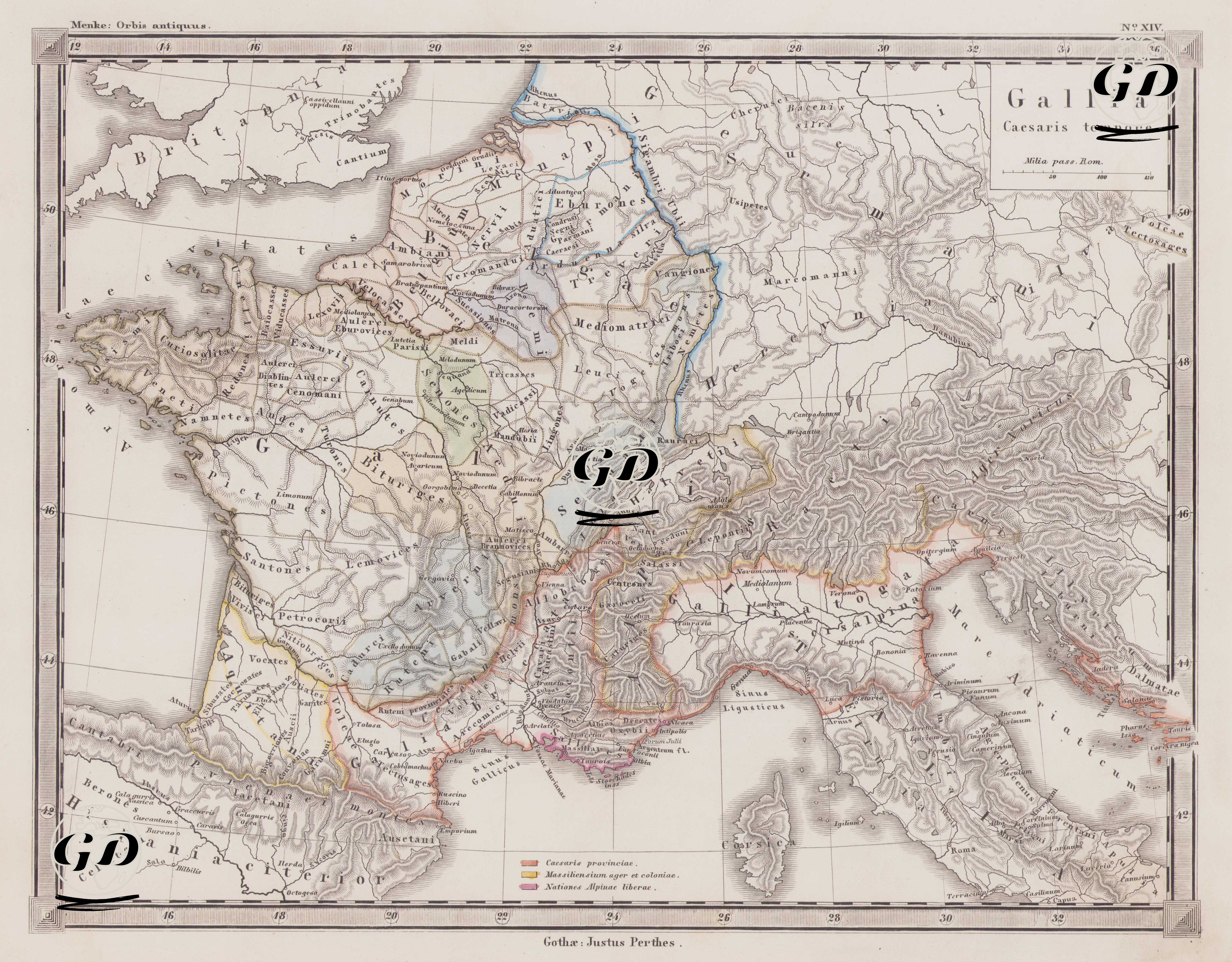
| Artist | Heinrich Theodor Menke (1819-1892) |
| Date | 1866 |
| Technique | Copper Engraving-Original Hand Colored |
| Category | Maps |
| Source | Orbis antiqui descriptio [cartographic material] : an atlas illustrating ancient history and geography by eighteen maps by Heinrich Theodor Menke - Published by Justus Perthes, Gotha |
This detailed ancient geographic map depicts ancient Gaul (Gallia) during Julius Caesar's Gallic Campaign (c. 58–50 BC). Its title includes the phrase "Gallia Caesaris tempore" (Gaul under Caesar). The map, part of the Orbis Antiquus (Ancient World) series published by Justus Perthes, reflects the Roman Republic's expansionist policies in Gaul, its administrative structures, and its interaction with the indigenous populations during the Gallic Wars. The map encompasses areas such as present-day France, Belgium, Luxembourg, western Switzerland, western Germany, and northern Italy, and provides a detailed view of Gaul's tribal divisions. Caesar's famous work, Commentarii de Bello Gallico (Commentaries on the Gallic War), directly references many of these tribes. The legend at the bottom of the map shows three main categories, designated by different color codes: 1. Caesaris provinciae; these represent the provinces under Caesar's direct authority and command. Gallia Narbonensis (Southern France – present-day Provence), in particular, was one of the oldest Roman provinces in Gaul and the central point of Roman administration in the 1st century BC. 2. Massiliensium ager et coloniae; represents the lands of the ancient people of Massilia (present-day Marseille) and the trading colonies of this city-state. Massilia, a colony of Greek origin, was an allied state with close trade relations and military cooperation with Rome. These regions were not established as Roman provinces, but as autonomous colonies operating in alliance with Rome. 3. Nationes Alpinae liberae; refers to the free peoples living in and around the Alps. The communities in these regions were not yet fully incorporated into Roman rule and were exempt from taxes or military obligations, serving as semi-independent or allied states. The mountainous regions inhabited by these peoples are shown by thin lines on the map. These regions would be annexed to Rome during the reign of Augustus (27 BC-14 AD) after Caesar. The map also marks in detail the important indigenous tribes and tribes that Caesar encountered during his Gallic Campaigns: tribes such as the Aedui, Arverni, Helvetii, Veneti, Belgae, Treveri, Remi, and Eburones; these were discussed in detail in Caesar’s work Commentarii de Bello Gallico. Caesar fought these tribes successively through diplomacy, alliance, and war, ultimately bringing all of Gaul under Roman rule. The map also indicates the names of important ancient rivers such as the Rhodanus (Rhone River), the Garumna (Garonne River), and the Sequana (Seine River). The northern borders of Roman Italy are shown, particularly demarcated by the Alps, and regions such as Liguria, Venetia, and Gallia Cisalpina are clearly visible. This map reflects not only the geography of Gaul but also how Rome, under Caesar's leadership, reshaped the region politically and militarily. The conquest of Gaul both expanded the borders of the Roman Republic and greatly increased Caesar's personal power. Caesar, who crossed the Rubicon in 49 BC and initiated the civil war, derived his fundamental military and political power from the support he received from these regions.