GRAVÜR DÜNYASI
Digital Engraving Library
| Artist | Heinrich Theodor Menke (1819-1892) |
| Engraver | Carl Poppey (1829-1875) |
| Date | 1866 |
| Technique | Copper Engraving-Original Hand Colored |
| Category | Maps |
| Source | Orbis antiqui descriptio [cartographic material] : an atlas illustrating ancient history and geography by eighteen maps by Heinrich Theodor Menke - Published by Justus Perthes, Gotha |
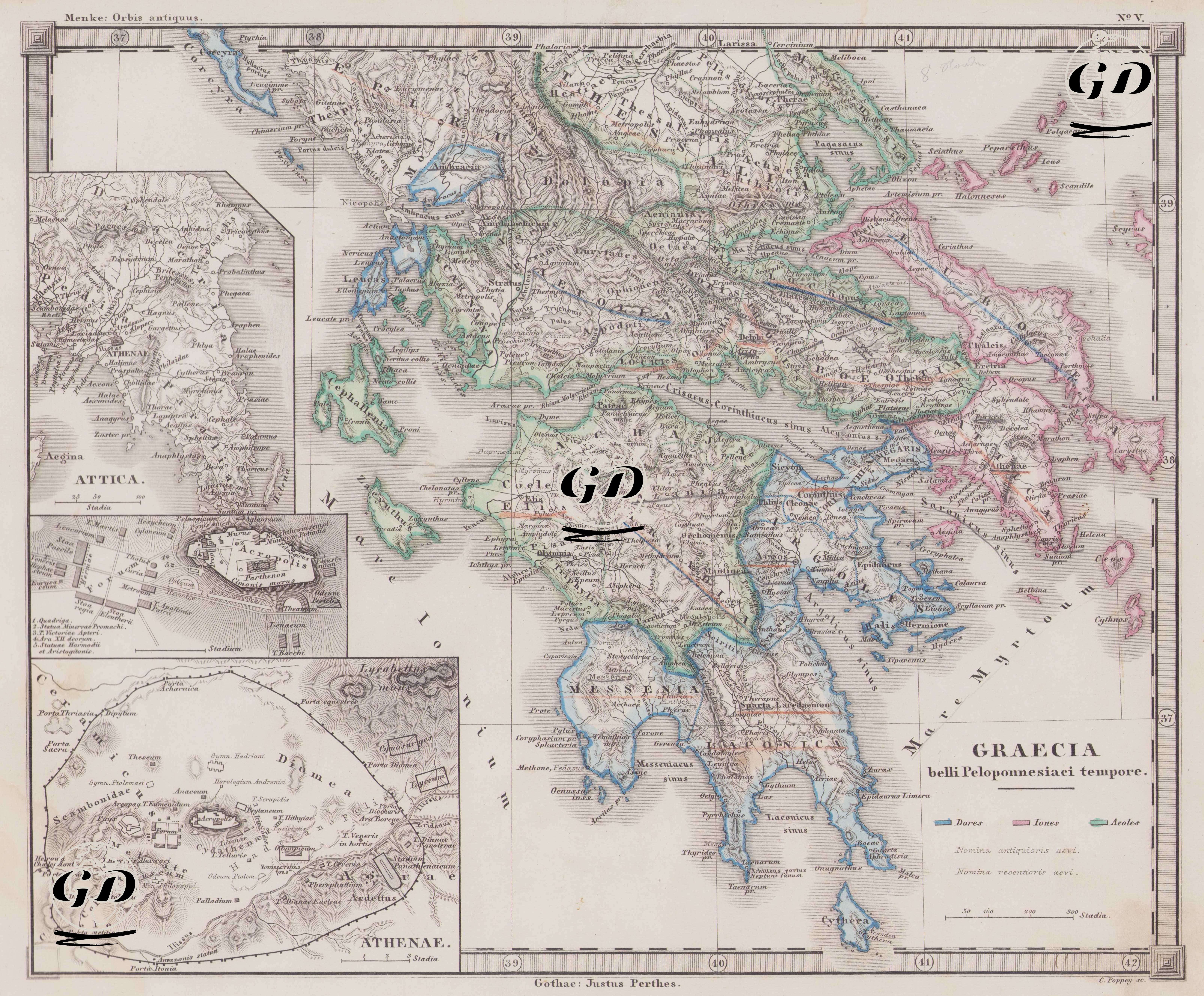
This map, number V of the Orbis Antiquus (Ancient World) atlas series included in Justus Perthes's classic geography series, is titled "Graecia belli Peloponnesiaci tempore" and depicts Greece during the Peloponnesian War. The map examines the military, political, and ethnic structure of the ancient Greek world against the backdrop of the major conflicts of the 5th century BC. The Peloponnesian War (431-404 BC) was particularly evident in this region, where the struggles between the Delian League, led by Athens, and the Peloponnesian League, led by Sparta, took place. The legend in the lower right corner of the map shows the three major Hellenic peoples (Hellenische Volksstämme): Dorians (Doroi – blue), Ionians (Ionai – reddish pink), and Aeolians (Aioleis – green). This ethnic color coding reflects not only linguistic or ethnic distinctions but also political, cultural, and regional affiliations. For example, the Dorians were concentrated in regions such as Sparta, Argos, and Crete; the Ionians in Athens, the Aegean islands, and coastal Anatolia; and the Aeolians, especially in Thessaly, Boeotia, and some Aegean islands. This distinction is crucial for understanding the blocs of the Peloponnesian War, as Sparta formed coalitions around a core of Dorians and Athens around Ionians. In the lower left corner of the map, there are two important detailed plans: one of Attica (Athens and its surrounding area), and the other a close-up of the Athenae, the city center of ancient Athens. The Athenaean plan shows structures such as the Acropolis, Areopagus, Pnyx, and the Theater of Dionysus in detail. Thanks to these submaps, the map reveals not only the macro-geography but also the internal structure of a city-state (polis). From a cartographic perspective, the map is extremely detailed; natural and settlement elements such as coastlines, river systems, ancient city names, and mountain ranges are meticulously depicted. Furthermore, the military strategy routes and borders of the period are also shown, providing a clear overview of how regional relations and borders were shaped in ancient times. This map is not merely a geographical representation, but a multilayered historical document that allows us to understand how ethnic, cultural, and political divisions were shaped in the Hellenistic world. It is an important resource for examining both the complex geopolitics of the Peloponnesian War and the spatial representation of ethnic affiliations on the map.