GRAVÜR DÜNYASI
Digital Engraving Library
| Artist | Heinrich Theodor Menke (1819-1892) |
| Date | 1866 |
| Technique | Copper Engraving-Original Hand Colored |
| Category | Maps |
| Source | Orbis antiqui descriptio [cartographic material] : an atlas illustrating ancient history and geography by eighteen maps by Heinrich Theodor Menke - Published by Justus Perthes, Gotha |
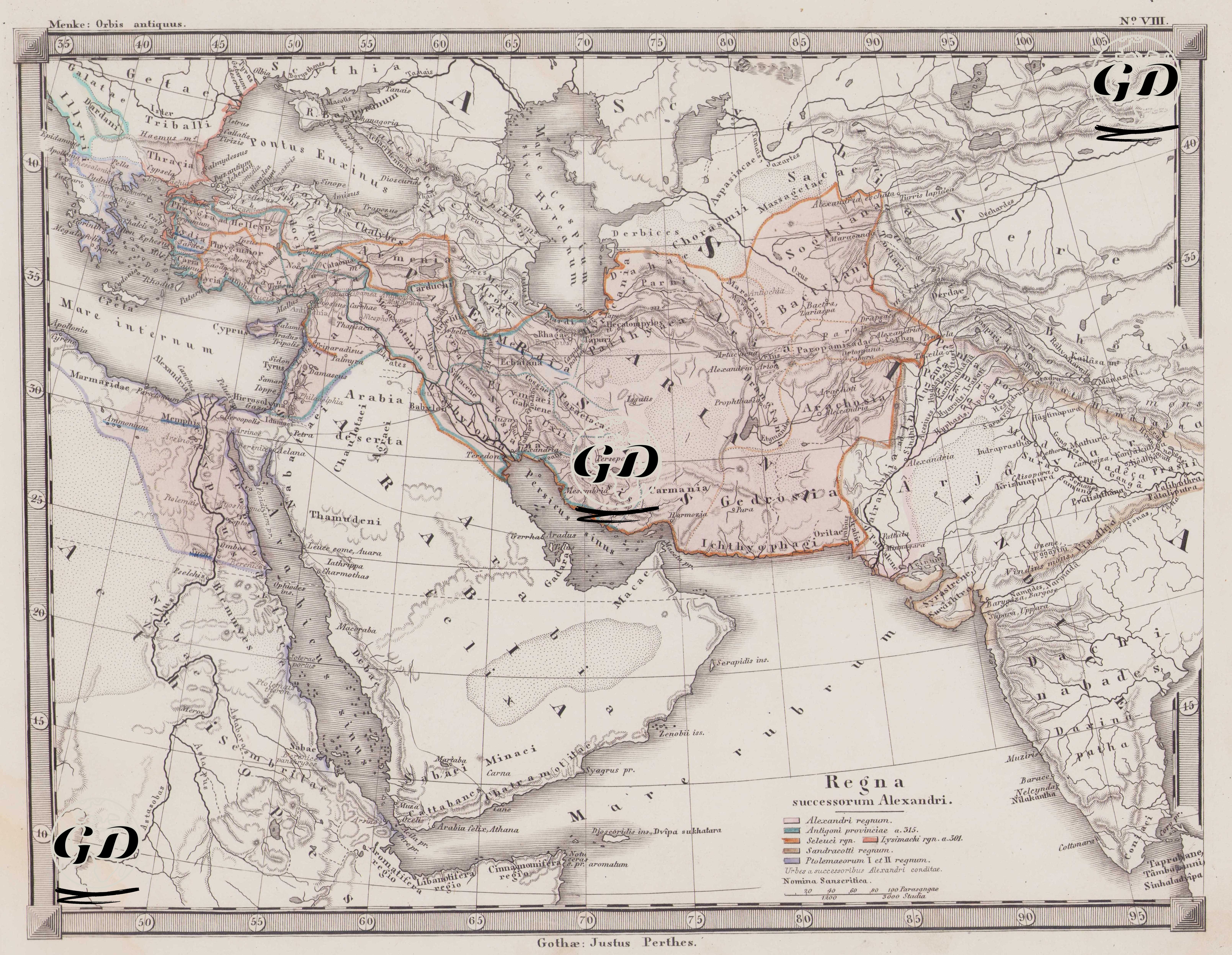
This map is number VIII of the Orbis Antiquus (Ancient World) atlas series in Justus Perthes's Classical Ancient Geography series. It bears the title "Regna Successorum Alexandri"; that is, "The Kingdoms of Alexander the Great's Successors." The map shows in detail the new political order that emerged with the disintegration of Alexander the Great's vast empire following his death in 323 BC. The legend (description box) at the bottom of the map indicates in color how this political structure was distributed among different kingdoms and provides significant historical details. The color coding in the legend is deciphered as follows: 1. Alexandri regnum: This clearly indicates the lands conquered during Alexander's lifetime. These areas extend from western Anatolia to Egypt, Mesopotamia, Iran, Central Asia, and northwest India. 2. Antigoni provinciae a. 315: This shows the provinces controlled by Antigonus Monophthalmus in 315 BC. Antigonos was one of Alexander's most powerful successors and ruled over much of Syria and Anatolia. 3. Seleucid dynasty: The Seleucid Kingdom founded by Seleucus Nicator. He ruled a vast area extending from Mesopotamia to Iran, Syria, and Central Asia. These regions are marked on the map with distinct colors. 4. Lysimachi regnum. 301 BC: This refers to Lysimachus's domains in 301 BC. This kingdom was generally located around Thrace and Western Anatolia. 5. Ptolemaeorum I et II regnum: This represents the kingdom centered in Egypt founded and ruled by the Ptolemaic dynasty in the 4th century BC. Egypt and its surroundings are shown in this color on the map. 6. Sandracotti regnum: This represents the region ruled by Chandragupta (Sandrakottos), founder of the Indian Maurya Empire. Founded after Alexander's expedition to India, this kingdom is important for defining its eastern borders. Additionally, two important sub-descriptions below the map offer valuable insights into the urbanization and cultural influences of the period: Urbes a successoribus Alexandri conditae: This phrase describes the cities founded by Alexander's successors. Many of these cities were built to spread Hellenistic culture and ensure perpetual political dominance. Important centers such as Seleucia, Antioch, and Alexandria are examples of these. Nomina Sanscritica: Sanskrit names found in the geography of India. This demonstrates the map's sensitivity to the cultural structure of the Indian subcontinent. Cartographically, the map details mountain ranges, river systems, seas, deserts, and trade routes. The Alexandri iter, or route of Alexander the Great's eastern campaign, is also carefully depicted. This route visually demonstrates the geographical projection of Alexander's military genius and the boundaries he reached. This map reveals not only political borders but also the expansion dynamics of the Hellenistic Period, Alexander's legacy, and the diverse cultural and military structures of the kingdoms that emerged after him.